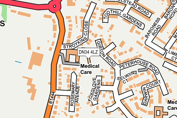
DN34 4LZ lies on St Margarets Mews in Grimsby. DN34 4LZ is located in the Yarborough electoral ward, within the unitary authority of North East Lincolnshire and the English Parliamentary constituency of Great Grimsby. The Sub Integrated Care Board (ICB) Location is NHS Humber and North Yorkshire ICB - 03H and the police force is Humberside. This postcode has been in use since July 1986.


GetTheData
Source: OS OpenMap – Local (Ordnance Survey)
Source: OS VectorMap District (Ordnance Survey)
Licence: Open Government Licence (requires attribution)
| Easting | 524747 |
| Northing | 408695 |
| Latitude | 53.560055 |
| Longitude | -0.118134 |
GetTheData
Source: Open Postcode Geo
Licence: Open Government Licence
| Street | St Margarets Mews |
| Town/City | Grimsby |
| Country | England |
| Postcode District | DN34 |
➜ See where DN34 is on a map ➜ Where is Grimsby? | |
GetTheData
Source: Land Registry Price Paid Data
Licence: Open Government Licence
Elevation or altitude of DN34 4LZ as distance above sea level:
| Metres | Feet | |
|---|---|---|
| Elevation | 10m | 33ft |
Elevation is measured from the approximate centre of the postcode, to the nearest point on an OS contour line from OS Terrain 50, which has contour spacing of ten vertical metres.
➜ How high above sea level am I? Find the elevation of your current position using your device's GPS.
GetTheData
Source: Open Postcode Elevation
Licence: Open Government Licence
| Ward | Yarborough |
| Constituency | Great Grimsby |
GetTheData
Source: ONS Postcode Database
Licence: Open Government Licence
| Rosemary Avenue (Little Coates Road) | Little Coates | 186m |
| Great Coates Road | Little Coates | 243m |
| Curry Road (Yarborough Road) | Little Coates | 243m |
| Curry Road (Yarborough Road) | Little Coates | 245m |
| Cambridge Road (Little Coates Road) | Little Coates | 267m |
| Great Coates Station | 1.9km |
| Grimsby Town Station | 2.1km |
| Grimsby Docks Station | 3.2km |
GetTheData
Source: NaPTAN
Licence: Open Government Licence
| Percentage of properties with Next Generation Access | 100.0% |
| Percentage of properties with Superfast Broadband | 100.0% |
| Percentage of properties with Ultrafast Broadband | 100.0% |
| Percentage of properties with Full Fibre Broadband | 0.0% |
Superfast Broadband is between 30Mbps and 300Mbps
Ultrafast Broadband is > 300Mbps
| Percentage of properties unable to receive 2Mbps | 0.0% |
| Percentage of properties unable to receive 5Mbps | 0.0% |
| Percentage of properties unable to receive 10Mbps | 0.0% |
| Percentage of properties unable to receive 30Mbps | 0.0% |
GetTheData
Source: Ofcom
Licence: Ofcom Terms of Use (requires attribution)
GetTheData
Source: ONS Postcode Database
Licence: Open Government Licence


➜ Get more ratings from the Food Standards Agency
GetTheData
Source: Food Standards Agency
Licence: FSA terms & conditions
| Last Collection | |||
|---|---|---|---|
| Location | Mon-Fri | Sat | Distance |
| Littlecotes Road | 17:30 | 11:30 | 96m |
| Kings Court | 17:45 | 11:30 | 295m |
| Yarrow Road | 17:00 | 10:45 | 446m |
GetTheData
Source: Dracos
Licence: Creative Commons Attribution-ShareAlike
The below table lists the International Territorial Level (ITL) codes (formerly Nomenclature of Territorial Units for Statistics (NUTS) codes) and Local Administrative Units (LAU) codes for DN34 4LZ:
| ITL 1 Code | Name |
|---|---|
| TLE | Yorkshire and The Humber |
| ITL 2 Code | Name |
| TLE1 | East Yorkshire and Northern Lincolnshire |
| ITL 3 Code | Name |
| TLE13 | North and North East Lincolnshire |
| LAU 1 Code | Name |
| E06000012 | North East Lincolnshire |
GetTheData
Source: ONS Postcode Directory
Licence: Open Government Licence
The below table lists the Census Output Area (OA), Lower Layer Super Output Area (LSOA), and Middle Layer Super Output Area (MSOA) for DN34 4LZ:
| Code | Name | |
|---|---|---|
| OA | E00066761 | |
| LSOA | E01033414 | North East Lincolnshire 009E |
| MSOA | E02002734 | North East Lincolnshire 009 |
GetTheData
Source: ONS Postcode Directory
Licence: Open Government Licence
| DN34 4JN | Rosemary Avenue | 64m |
| DN34 5XU | Girton Road | 70m |
| DN34 4NJ | Rosemary Avenue | 93m |
| DN34 5XT | St Edmunds Court | 94m |
| DN34 4NH | Rosemary Avenue | 104m |
| DN34 4NQ | Little Coates Road | 113m |
| DN34 5XN | Foxglove Gardens | 118m |
| DN34 4NG | Little Coates Road | 119m |
| DN34 4NF | Stroykins Close | 129m |
| DN34 4LY | Little Coates Road | 140m |
GetTheData
Source: Open Postcode Geo; Land Registry Price Paid Data
Licence: Open Government Licence