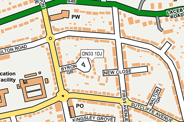
DN33 1DJ lies on Byron Grove in Grimsby. DN33 1DJ is located in the South electoral ward, within the unitary authority of North East Lincolnshire and the English Parliamentary constituency of Great Grimsby. The Sub Integrated Care Board (ICB) Location is NHS Humber and North Yorkshire ICB - 03H and the police force is Humberside. This postcode has been in use since January 1980.


GetTheData
Source: OS OpenMap – Local (Ordnance Survey)
Source: OS VectorMap District (Ordnance Survey)
Licence: Open Government Licence (requires attribution)
| Easting | 526105 |
| Northing | 407707 |
| Latitude | 53.550856 |
| Longitude | -0.098042 |
GetTheData
Source: Open Postcode Geo
Licence: Open Government Licence
| Street | Byron Grove |
| Town/City | Grimsby |
| Country | England |
| Postcode District | DN33 |
➜ See where DN33 is on a map ➜ Where is Grimsby? | |
GetTheData
Source: Land Registry Price Paid Data
Licence: Open Government Licence
Elevation or altitude of DN33 1DJ as distance above sea level:
| Metres | Feet | |
|---|---|---|
| Elevation | 10m | 33ft |
Elevation is measured from the approximate centre of the postcode, to the nearest point on an OS contour line from OS Terrain 50, which has contour spacing of ten vertical metres.
➜ How high above sea level am I? Find the elevation of your current position using your device's GPS.
GetTheData
Source: Open Postcode Elevation
Licence: Open Government Licence
| Ward | South |
| Constituency | Great Grimsby |
GetTheData
Source: ONS Postcode Database
Licence: Open Government Licence
| Sutcliffe Avenue | Nunsthorpe | 120m |
| First Avenue (Laceby Road) | Grange | 180m |
| Sutcliffe Avenue | Nunsthorpe | 199m |
| Walton Grove (Sutcliffe Avenue) | Nunsthorpe | 207m |
| Walton Grove (Sutcliffe Avenue) | Nunsthorpe | 216m |
| Grimsby Town Station | 1.6km |
| Grimsby Docks Station | 3km |
| Great Coates Station | 3.5km |
GetTheData
Source: NaPTAN
Licence: Open Government Licence
| Percentage of properties with Next Generation Access | 100.0% |
| Percentage of properties with Superfast Broadband | 100.0% |
| Percentage of properties with Ultrafast Broadband | 100.0% |
| Percentage of properties with Full Fibre Broadband | 0.0% |
Superfast Broadband is between 30Mbps and 300Mbps
Ultrafast Broadband is > 300Mbps
| Median download speed | 39.0Mbps |
| Average download speed | 89.6Mbps |
| Maximum download speed | 350.00Mbps |
| Median upload speed | 1.3Mbps |
| Average upload speed | 3.7Mbps |
| Maximum upload speed | 9.76Mbps |
| Percentage of properties unable to receive 2Mbps | 0.0% |
| Percentage of properties unable to receive 5Mbps | 0.0% |
| Percentage of properties unable to receive 10Mbps | 0.0% |
| Percentage of properties unable to receive 30Mbps | 0.0% |
GetTheData
Source: Ofcom
Licence: Ofcom Terms of Use (requires attribution)
Estimated total energy consumption in DN33 1DJ by fuel type, 2015.
| Consumption (kWh) | 368,730 |
|---|---|
| Meter count | 35 |
| Mean (kWh/meter) | 10,535 |
| Median (kWh/meter) | 11,100 |
| Consumption (kWh) | 140,394 |
|---|---|
| Meter count | 33 |
| Mean (kWh/meter) | 4,254 |
| Median (kWh/meter) | 4,111 |
GetTheData
Source: Postcode level gas estimates: 2015 (experimental)
Source: Postcode level electricity estimates: 2015 (experimental)
Licence: Open Government Licence
GetTheData
Source: ONS Postcode Database
Licence: Open Government Licence


➜ Get more ratings from the Food Standards Agency
GetTheData
Source: Food Standards Agency
Licence: FSA terms & conditions
| Last Collection | |||
|---|---|---|---|
| Location | Mon-Fri | Sat | Distance |
| Nunsthorpe P.o. | 17:30 | 12:00 | 157m |
| Laceby Road | 17:30 | 11:45 | 310m |
| Laceby Road | 17:30 | 11:45 | 566m |
GetTheData
Source: Dracos
Licence: Creative Commons Attribution-ShareAlike
The below table lists the International Territorial Level (ITL) codes (formerly Nomenclature of Territorial Units for Statistics (NUTS) codes) and Local Administrative Units (LAU) codes for DN33 1DJ:
| ITL 1 Code | Name |
|---|---|
| TLE | Yorkshire and The Humber |
| ITL 2 Code | Name |
| TLE1 | East Yorkshire and Northern Lincolnshire |
| ITL 3 Code | Name |
| TLE13 | North and North East Lincolnshire |
| LAU 1 Code | Name |
| E06000012 | North East Lincolnshire |
GetTheData
Source: ONS Postcode Directory
Licence: Open Government Licence
The below table lists the Census Output Area (OA), Lower Layer Super Output Area (LSOA), and Middle Layer Super Output Area (MSOA) for DN33 1DJ:
| Code | Name | |
|---|---|---|
| OA | E00066653 | |
| LSOA | E01013205 | North East Lincolnshire 019B |
| MSOA | E02002744 | North East Lincolnshire 019 |
GetTheData
Source: ONS Postcode Directory
Licence: Open Government Licence
| DN33 1BP | New Close | 53m |
| DN33 1DE | Milton Road | 78m |
| DN33 1BW | First Avenue | 79m |
| DN33 1DH | Second Avenue | 99m |
| DN33 1AQ | Sutcliffe Avenue | 101m |
| DN33 1DD | Milton Road | 109m |
| DN33 1DA | First Avenue | 112m |
| DN33 1BN | First Avenue | 132m |
| DN33 1DQ | Second Avenue | 135m |
| DN33 1DR | Sutcliffe Avenue | 140m |
GetTheData
Source: Open Postcode Geo; Land Registry Price Paid Data
Licence: Open Government Licence