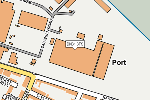
DN31 3FS is located in the Sidney Sussex electoral ward, within the unitary authority of North East Lincolnshire and the English Parliamentary constituency of Cleethorpes. The Sub Integrated Care Board (ICB) Location is NHS Humber and North Yorkshire ICB - 03H and the police force is Humberside. This postcode has been in use since June 1997.


GetTheData
Source: OS OpenMap – Local (Ordnance Survey)
Source: OS VectorMap District (Ordnance Survey)
Licence: Open Government Licence (requires attribution)
| Easting | 529033 |
| Northing | 410367 |
| Latitude | 53.574040 |
| Longitude | -0.052778 |
GetTheData
Source: Open Postcode Geo
Licence: Open Government Licence
| Country | England |
| Postcode District | DN31 |
➜ See where DN31 is on a map ➜ Where is Grimsby? | |
GetTheData
Source: Land Registry Price Paid Data
Licence: Open Government Licence
Elevation or altitude of DN31 3FS as distance above sea level:
| Metres | Feet | |
|---|---|---|
| Elevation | 10m | 33ft |
Elevation is measured from the approximate centre of the postcode, to the nearest point on an OS contour line from OS Terrain 50, which has contour spacing of ten vertical metres.
➜ How high above sea level am I? Find the elevation of your current position using your device's GPS.
GetTheData
Source: Open Postcode Elevation
Licence: Open Government Licence
| Ward | Sidney Sussex |
| Constituency | Cleethorpes |
GetTheData
Source: ONS Postcode Database
Licence: Open Government Licence
| Park Street (Grimsby Road) | Cleethorpes | 351m |
| Barcroft Street (Grimsby Road) | Cleethorpes | 412m |
| Ramsdens (Cleethorpe Road) | East Marsh | 416m |
| Ramsdens (Cleethorpe Road) | East Marsh | 433m |
| Barcroft Street (Grimsby Road) | Cleethorpes | 448m |
| New Clee Station | 0.5km |
| Grimsby Docks Station | 1.5km |
| Cleethorpes Station | 2.1km |
GetTheData
Source: NaPTAN
Licence: Open Government Licence
GetTheData
Source: ONS Postcode Database
Licence: Open Government Licence

➜ Get more ratings from the Food Standards Agency
GetTheData
Source: Food Standards Agency
Licence: FSA terms & conditions
| Last Collection | |||
|---|---|---|---|
| Location | Mon-Fri | Sat | Distance |
| Grimsby Road Cleethorpes P.o. | 17:30 | 12:30 | 429m |
| Grimsby Road | 17:30 | 11:30 | 581m |
| Brereton Avenue | 17:30 | 10:00 | 627m |
GetTheData
Source: Dracos
Licence: Creative Commons Attribution-ShareAlike
The below table lists the International Territorial Level (ITL) codes (formerly Nomenclature of Territorial Units for Statistics (NUTS) codes) and Local Administrative Units (LAU) codes for DN31 3FS:
| ITL 1 Code | Name |
|---|---|
| TLE | Yorkshire and The Humber |
| ITL 2 Code | Name |
| TLE1 | East Yorkshire and Northern Lincolnshire |
| ITL 3 Code | Name |
| TLE13 | North and North East Lincolnshire |
| LAU 1 Code | Name |
| E06000012 | North East Lincolnshire |
GetTheData
Source: ONS Postcode Directory
Licence: Open Government Licence
The below table lists the Census Output Area (OA), Lower Layer Super Output Area (LSOA), and Middle Layer Super Output Area (MSOA) for DN31 3FS:
| Code | Name | |
|---|---|---|
| OA | E00066615 | |
| LSOA | E01013201 | North East Lincolnshire 005C |
| MSOA | E02002730 | North East Lincolnshire 005 |
GetTheData
Source: ONS Postcode Directory
Licence: Open Government Licence
| DN35 7AY | Harrington Street | 170m |
| DN35 7AZ | Harrington Street | 198m |
| DN35 7AU | Phelps Street | 214m |
| DN35 7AX | Taylor Street | 216m |
| DN35 7BD | Harrington Street | 243m |
| DN35 7AS | Phelps Street | 263m |
| DN35 7AT | Phelps Street | 271m |
| DN35 7BA | Daubney Street | 287m |
| DN35 7BB | Daubney Street | 298m |
| DN35 7AP | Montague Street | 304m |
GetTheData
Source: Open Postcode Geo; Land Registry Price Paid Data
Licence: Open Government Licence