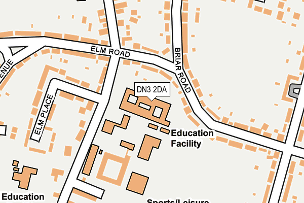
DN3 2DA is located in the Armthorpe electoral ward, within the metropolitan district of Doncaster and the English Parliamentary constituency of Doncaster Central. The Sub Integrated Care Board (ICB) Location is NHS South Yorkshire ICB - 02X and the police force is South Yorkshire. This postcode has been in use since January 1980.


GetTheData
Source: OS OpenMap – Local (Ordnance Survey)
Source: OS VectorMap District (Ordnance Survey)
Licence: Open Government Licence (requires attribution)
| Easting | 462410 |
| Northing | 405237 |
| Latitude | 53.540080 |
| Longitude | -1.059732 |
GetTheData
Source: Open Postcode Geo
Licence: Open Government Licence
| Country | England |
| Postcode District | DN3 |
➜ See where DN3 is on a map ➜ Where is Armthorpe? | |
GetTheData
Source: Land Registry Price Paid Data
Licence: Open Government Licence
Elevation or altitude of DN3 2DA as distance above sea level:
| Metres | Feet | |
|---|---|---|
| Elevation | 10m | 33ft |
Elevation is measured from the approximate centre of the postcode, to the nearest point on an OS contour line from OS Terrain 50, which has contour spacing of ten vertical metres.
➜ How high above sea level am I? Find the elevation of your current position using your device's GPS.
GetTheData
Source: Open Postcode Elevation
Licence: Open Government Licence
| Ward | Armthorpe |
| Constituency | Doncaster Central |
GetTheData
Source: ONS Postcode Database
Licence: Open Government Licence
| Elm Road (Briar Road) | Armthorpe | 65m |
| Elm Road (Briar Road) | Armthorpe | 76m |
| Elm Place (Mere Lane) | Armthorpe | 82m |
| Mere Lane (Elm Road) | Armthorpe | 111m |
| The Practice (Mere Lane) | Armthorpe | 143m |
| Kirk Sandall Station | 2.8km |
GetTheData
Source: NaPTAN
Licence: Open Government Licence
GetTheData
Source: ONS Postcode Database
Licence: Open Government Licence


➜ Get more ratings from the Food Standards Agency
GetTheData
Source: Food Standards Agency
Licence: FSA terms & conditions
| Last Collection | |||
|---|---|---|---|
| Location | Mon-Fri | Sat | Distance |
| Briar Road | 17:00 | 10:00 | 124m |
| Armthorpe Post Office | 17:00 | 12:15 | 409m |
| Doncaster Road | 17:00 | 09:00 | 692m |
GetTheData
Source: Dracos
Licence: Creative Commons Attribution-ShareAlike
The below table lists the International Territorial Level (ITL) codes (formerly Nomenclature of Territorial Units for Statistics (NUTS) codes) and Local Administrative Units (LAU) codes for DN3 2DA:
| ITL 1 Code | Name |
|---|---|
| TLE | Yorkshire and The Humber |
| ITL 2 Code | Name |
| TLE3 | South Yorkshire |
| ITL 3 Code | Name |
| TLE31 | Barnsley, Doncaster and Rotherham |
| LAU 1 Code | Name |
| E08000017 | Doncaster |
GetTheData
Source: ONS Postcode Directory
Licence: Open Government Licence
The below table lists the Census Output Area (OA), Lower Layer Super Output Area (LSOA), and Middle Layer Super Output Area (MSOA) for DN3 2DA:
| Code | Name | |
|---|---|---|
| OA | E00037899 | |
| LSOA | E01007480 | Doncaster 014B |
| MSOA | E02001552 | Doncaster 014 |
GetTheData
Source: ONS Postcode Directory
Licence: Open Government Licence
| DN3 2DF | Mere Lane | 109m |
| DN3 2EE | Briar Road | 127m |
| DN3 2BB | Elm Road | 135m |
| DN3 2DB | Mere Lane | 145m |
| DN3 2BZ | Mere Lane | 155m |
| DN3 2BA | Elm Road | 164m |
| DN3 2DE | Elm Place | 193m |
| DN3 2DN | Briar Road | 215m |
| DN3 2DL | Briar Road | 216m |
| DN3 2BG | Mere Lane | 228m |
GetTheData
Source: Open Postcode Geo; Land Registry Price Paid Data
Licence: Open Government Licence