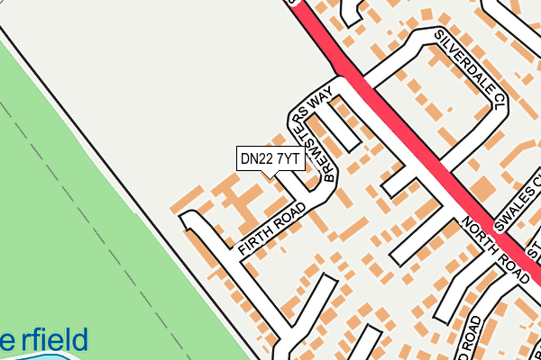
DN22 7YT lies on North Walk in Retford. DN22 7YT is located in the East Retford North electoral ward, within the local authority district of Bassetlaw and the English Parliamentary constituency of Bassetlaw. The Sub Integrated Care Board (ICB) Location is NHS Nottingham and Nottinghamshire ICB - 02Q and the police force is Nottinghamshire. This postcode has been in use since January 1980.


GetTheData
Source: OS OpenMap – Local (Ordnance Survey)
Source: OS VectorMap District (Ordnance Survey)
Licence: Open Government Licence (requires attribution)
| Easting | 469034 |
| Northing | 381990 |
| Latitude | 53.330331 |
| Longitude | -0.964884 |
GetTheData
Source: Open Postcode Geo
Licence: Open Government Licence
| Street | North Walk |
| Town/City | Retford |
| Country | England |
| Postcode District | DN22 |
➜ See where DN22 is on a map ➜ Where is Retford? | |
GetTheData
Source: Land Registry Price Paid Data
Licence: Open Government Licence
Elevation or altitude of DN22 7YT as distance above sea level:
| Metres | Feet | |
|---|---|---|
| Elevation | 20m | 66ft |
Elevation is measured from the approximate centre of the postcode, to the nearest point on an OS contour line from OS Terrain 50, which has contour spacing of ten vertical metres.
➜ How high above sea level am I? Find the elevation of your current position using your device's GPS.
GetTheData
Source: Open Postcode Elevation
Licence: Open Government Licence
| Ward | East Retford North |
| Constituency | Bassetlaw |
GetTheData
Source: ONS Postcode Database
Licence: Open Government Licence
| Silverdale Close (North Road) | Retford | 173m |
| Silverdale Close (North Road) | Retford | 175m |
| North Road | Hallcroft | 264m |
| Randall Way | Hallcroft | 320m |
| Randall Way | Hallcroft | 332m |
| Retford Station | 2km |
| Retford Low Level Station | 2.3km |
GetTheData
Source: NaPTAN
Licence: Open Government Licence
| Percentage of properties with Next Generation Access | 100.0% |
| Percentage of properties with Superfast Broadband | 100.0% |
| Percentage of properties with Ultrafast Broadband | 0.0% |
| Percentage of properties with Full Fibre Broadband | 0.0% |
Superfast Broadband is between 30Mbps and 300Mbps
Ultrafast Broadband is > 300Mbps
| Percentage of properties unable to receive 2Mbps | 0.0% |
| Percentage of properties unable to receive 5Mbps | 0.0% |
| Percentage of properties unable to receive 10Mbps | 0.0% |
| Percentage of properties unable to receive 30Mbps | 0.0% |
GetTheData
Source: Ofcom
Licence: Ofcom Terms of Use (requires attribution)
GetTheData
Source: ONS Postcode Database
Licence: Open Government Licence


➜ Get more ratings from the Food Standards Agency
GetTheData
Source: Food Standards Agency
Licence: FSA terms & conditions
| Last Collection | |||
|---|---|---|---|
| Location | Mon-Fri | Sat | Distance |
| North Road | 17:30 | 11:45 | 135m |
| Fulford Avenue | 17:30 | 11:45 | 429m |
| West Hill Road | 17:15 | 12:00 | 430m |
GetTheData
Source: Dracos
Licence: Creative Commons Attribution-ShareAlike
The below table lists the International Territorial Level (ITL) codes (formerly Nomenclature of Territorial Units for Statistics (NUTS) codes) and Local Administrative Units (LAU) codes for DN22 7YT:
| ITL 1 Code | Name |
|---|---|
| TLF | East Midlands (England) |
| ITL 2 Code | Name |
| TLF1 | Derbyshire and Nottinghamshire |
| ITL 3 Code | Name |
| TLF15 | North Nottinghamshire |
| LAU 1 Code | Name |
| E07000171 | Bassetlaw |
GetTheData
Source: ONS Postcode Directory
Licence: Open Government Licence
The below table lists the Census Output Area (OA), Lower Layer Super Output Area (LSOA), and Middle Layer Super Output Area (MSOA) for DN22 7YT:
| Code | Name | |
|---|---|---|
| OA | E00142731 | |
| LSOA | E01028016 | Bassetlaw 005D |
| MSOA | E02005839 | Bassetlaw 005 |
GetTheData
Source: ONS Postcode Directory
Licence: Open Government Licence
| DN22 7YU | Boundary Walk | 34m |
| DN22 7YS | Firth Road | 61m |
| DN22 7YX | Long Walk | 67m |
| DN22 7YJ | Galway Crescent | 79m |
| DN22 7YG | Brewsters Way | 81m |
| DN22 7YW | North Road | 110m |
| DN22 7YQ | Millers Way | 110m |
| DN22 7YL | West Walk | 118m |
| DN22 7YR | Galway Crescent | 124m |
| DN22 7YF | East Walk | 149m |
GetTheData
Source: Open Postcode Geo; Land Registry Price Paid Data
Licence: Open Government Licence