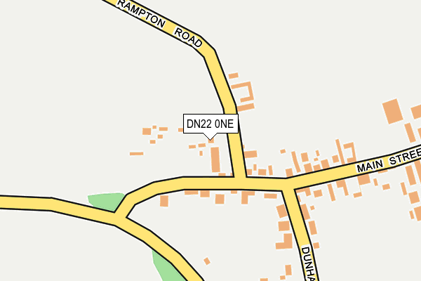
DN22 0NE lies on Rampton Road in Laneham, Retford. DN22 0NE is located in the Tuxford and Trent electoral ward, within the local authority district of Bassetlaw and the English Parliamentary constituency of Newark. The Sub Integrated Care Board (ICB) Location is NHS Nottingham and Nottinghamshire ICB - 02Q and the police force is Nottinghamshire. This postcode has been in use since January 1980.


GetTheData
Source: OS OpenMap – Local (Ordnance Survey)
Source: OS VectorMap District (Ordnance Survey)
Licence: Open Government Licence (requires attribution)
| Easting | 480229 |
| Northing | 376272 |
| Latitude | 53.277369 |
| Longitude | -0.798267 |
GetTheData
Source: Open Postcode Geo
Licence: Open Government Licence
| Street | Rampton Road |
| Locality | Laneham |
| Town/City | Retford |
| Country | England |
| Postcode District | DN22 |
➜ See where DN22 is on a map ➜ Where is Laneham? | |
GetTheData
Source: Land Registry Price Paid Data
Licence: Open Government Licence
Elevation or altitude of DN22 0NE as distance above sea level:
| Metres | Feet | |
|---|---|---|
| Elevation | 10m | 33ft |
Elevation is measured from the approximate centre of the postcode, to the nearest point on an OS contour line from OS Terrain 50, which has contour spacing of ten vertical metres.
➜ How high above sea level am I? Find the elevation of your current position using your device's GPS.
GetTheData
Source: Open Postcode Elevation
Licence: Open Government Licence
| Ward | Tuxford And Trent |
| Constituency | Newark |
GetTheData
Source: ONS Postcode Database
Licence: Open Government Licence
APPLE TREE HOUSE, RAMPTON ROAD, LANEHAM, RETFORD, DN22 0NE 2014 3 JAN £303,000 |
2, RAMPTON ROAD, LANEHAM, RETFORD, DN22 0NE 2013 3 MAY £185,000 |
THE BUNGALOW, RAMPTON ROAD, LANEHAM, RETFORD, DN22 0NE 2006 27 OCT £160,000 |
THE BUNGALOW, RAMPTON ROAD, LANEHAM, RETFORD, DN22 0NE 2002 6 FEB £59,950 |
THE WHITEHOUSE, RAMPTON ROAD, LANEHAM, RETFORD, DN22 0NE 1998 17 DEC £112,000 |
GetTheData
Source: HM Land Registry Price Paid Data
Licence: Contains HM Land Registry data © Crown copyright and database right 2025. This data is licensed under the Open Government Licence v3.0.
| Dunham Road | Laneham | 143m |
| Dunham Road | Laneham | 144m |
| Demand Responsive Area (Phoneabus) | Laneham | 368m |
| Main Street | Laneham | 374m |
| Main Street | Laneham | 375m |
GetTheData
Source: NaPTAN
Licence: Open Government Licence
| Percentage of properties with Next Generation Access | 100.0% |
| Percentage of properties with Superfast Broadband | 100.0% |
| Percentage of properties with Ultrafast Broadband | 0.0% |
| Percentage of properties with Full Fibre Broadband | 0.0% |
Superfast Broadband is between 30Mbps and 300Mbps
Ultrafast Broadband is > 300Mbps
| Median download speed | 80.0Mbps |
| Average download speed | 65.7Mbps |
| Maximum download speed | 80.00Mbps |
| Median upload speed | 20.0Mbps |
| Average upload speed | 16.6Mbps |
| Maximum upload speed | 20.00Mbps |
| Percentage of properties unable to receive 2Mbps | 0.0% |
| Percentage of properties unable to receive 5Mbps | 0.0% |
| Percentage of properties unable to receive 10Mbps | 0.0% |
| Percentage of properties unable to receive 30Mbps | 0.0% |
GetTheData
Source: Ofcom
Licence: Ofcom Terms of Use (requires attribution)
GetTheData
Source: ONS Postcode Database
Licence: Open Government Licence


➜ Get more ratings from the Food Standards Agency
GetTheData
Source: Food Standards Agency
Licence: FSA terms & conditions
| Last Collection | |||
|---|---|---|---|
| Location | Mon-Fri | Sat | Distance |
| Laneham P.o. | 16:30 | 11:00 | 175m |
| Church Laneham | 16:30 | 11:00 | 1,287m |
| Stockham | 16:15 | 11:15 | 1,898m |
GetTheData
Source: Dracos
Licence: Creative Commons Attribution-ShareAlike
The below table lists the International Territorial Level (ITL) codes (formerly Nomenclature of Territorial Units for Statistics (NUTS) codes) and Local Administrative Units (LAU) codes for DN22 0NE:
| ITL 1 Code | Name |
|---|---|
| TLF | East Midlands (England) |
| ITL 2 Code | Name |
| TLF1 | Derbyshire and Nottinghamshire |
| ITL 3 Code | Name |
| TLF15 | North Nottinghamshire |
| LAU 1 Code | Name |
| E07000171 | Bassetlaw |
GetTheData
Source: ONS Postcode Directory
Licence: Open Government Licence
The below table lists the Census Output Area (OA), Lower Layer Super Output Area (LSOA), and Middle Layer Super Output Area (MSOA) for DN22 0NE:
| Code | Name | |
|---|---|---|
| OA | E00142860 | |
| LSOA | E01028039 | Bassetlaw 015F |
| MSOA | E02005849 | Bassetlaw 015 |
GetTheData
Source: ONS Postcode Directory
Licence: Open Government Licence
| DN22 0ND | Main Street | 52m |
| DN22 0NA | Main Street | 123m |
| DN22 0NB | Dunham Road | 213m |
| DN22 0NF | Broadings Lane | 378m |
| DN22 0NG | Main Street | 478m |
| DN22 0NL | Broadings Lane | 740m |
| DN22 0NN | Broadings Lane | 1202m |
| DN22 0NQ | 1228m | |
| DN22 0NJ | 1497m | |
| NG22 0UD | Chequers Lane | 1599m |
GetTheData
Source: Open Postcode Geo; Land Registry Price Paid Data
Licence: Open Government Licence