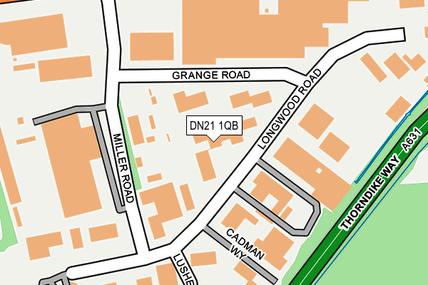
DN21 1QB lies on Corringham Road Industrial Estate in Gainsborough. DN21 1QB is located in the Hemswell electoral ward, within the local authority district of West Lindsey and the English Parliamentary constituency of Gainsborough. The Sub Integrated Care Board (ICB) Location is NHS Lincolnshire ICB - 71E and the police force is Lincolnshire. This postcode has been in use since January 1980.


GetTheData
Source: OS OpenMap – Local (Ordnance Survey)
Source: OS VectorMap District (Ordnance Survey)
Licence: Open Government Licence (requires attribution)
| Easting | 483654 |
| Northing | 390438 |
| Latitude | 53.404164 |
| Longitude | -0.743181 |
GetTheData
Source: Open Postcode Geo
Licence: Open Government Licence
| Street | Corringham Road Industrial Estate |
| Town/City | Gainsborough |
| Country | England |
| Postcode District | DN21 |
➜ See where DN21 is on a map ➜ Where is Gainsborough? | |
GetTheData
Source: Land Registry Price Paid Data
Licence: Open Government Licence
Elevation or altitude of DN21 1QB as distance above sea level:
| Metres | Feet | |
|---|---|---|
| Elevation | 30m | 98ft |
Elevation is measured from the approximate centre of the postcode, to the nearest point on an OS contour line from OS Terrain 50, which has contour spacing of ten vertical metres.
➜ How high above sea level am I? Find the elevation of your current position using your device's GPS.
GetTheData
Source: Open Postcode Elevation
Licence: Open Government Licence
| Ward | Hemswell |
| Constituency | Gainsborough |
GetTheData
Source: ONS Postcode Database
Licence: Open Government Licence
| Grange Road (Miller Road) | Gainsborough | 444m |
| Miller Road (Corringham Road) | Gainsborough | 467m |
| Grange Road (Miller Road) | Gainsborough | 488m |
| Miller Road (Corringham Road) | Gainsborough | 492m |
| Long Wood Road (Lusher Road) | Gainsborough | 499m |
| Gainsborough Central Station | 1.8km |
| Gainsborough Lea Road Station | 2.6km |
GetTheData
Source: NaPTAN
Licence: Open Government Licence
| Median download speed | 30.6Mbps |
| Average download speed | 26.7Mbps |
| Maximum download speed | 53.22Mbps |
| Median upload speed | 6.3Mbps |
| Average upload speed | 5.6Mbps |
| Maximum upload speed | 13.52Mbps |
GetTheData
Source: Ofcom
Licence: Ofcom Terms of Use (requires attribution)
Estimated total energy consumption in DN21 1QB by fuel type, 2015.
| Consumption (kWh) | 266,308 |
|---|---|
| Meter count | 22 |
| Mean (kWh/meter) | 12,105 |
| Median (kWh/meter) | 2,970 |
GetTheData
Source: Postcode level gas estimates: 2015 (experimental)
Source: Postcode level electricity estimates: 2015 (experimental)
Licence: Open Government Licence
GetTheData
Source: ONS Postcode Database
Licence: Open Government Licence


➜ Get more ratings from the Food Standards Agency
GetTheData
Source: Food Standards Agency
Licence: FSA terms & conditions
| Last Collection | |||
|---|---|---|---|
| Location | Mon-Fri | Sat | Distance |
| Corringham Road | 18:45 | 11:00 | 640m |
| Corringham Road | 18:45 | 660m | |
| Eastern Avenue | 17:00 | 12:00 | 945m |
GetTheData
Source: Dracos
Licence: Creative Commons Attribution-ShareAlike
The below table lists the International Territorial Level (ITL) codes (formerly Nomenclature of Territorial Units for Statistics (NUTS) codes) and Local Administrative Units (LAU) codes for DN21 1QB:
| ITL 1 Code | Name |
|---|---|
| TLF | East Midlands (England) |
| ITL 2 Code | Name |
| TLF3 | Lincolnshire |
| ITL 3 Code | Name |
| TLF30 | Lincolnshire CC |
| LAU 1 Code | Name |
| E07000142 | West Lindsey |
GetTheData
Source: ONS Postcode Directory
Licence: Open Government Licence
The below table lists the Census Output Area (OA), Lower Layer Super Output Area (LSOA), and Middle Layer Super Output Area (MSOA) for DN21 1QB:
| Code | Name | |
|---|---|---|
| OA | E00134043 | |
| LSOA | E01026385 | West Lindsey 005A |
| MSOA | E02005496 | West Lindsey 005 |
GetTheData
Source: ONS Postcode Directory
Licence: Open Government Licence
| DN21 1QA | The Belt Road | 594m |
| DN21 1GU | Swan Court | 743m |
| DN21 1GH | Peacock Place | 753m |
| DN21 1GF | Dove Close | 762m |
| DN21 1RL | Holme Walk | 775m |
| DN21 1RJ | Theaker Avenue | 789m |
| DN21 1GJ | Heron Drive | 796m |
| DN21 1RH | Theaker Avenue | 820m |
| DN21 1SX | Newton Close | 850m |
| DN21 1TQ | Whites Wood Lane | 867m |
GetTheData
Source: Open Postcode Geo; Land Registry Price Paid Data
Licence: Open Government Licence