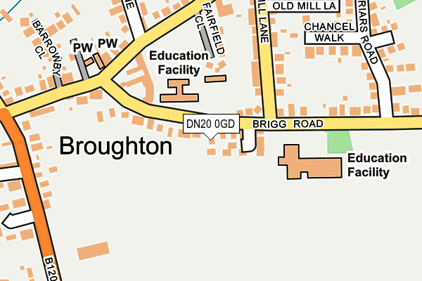
DN20 0GD lies on Old School Gardens in Broughton, Brigg. DN20 0GD is located in the Broughton & Scawby electoral ward, within the unitary authority of North Lincolnshire and the English Parliamentary constituency of Brigg and Goole. The Sub Integrated Care Board (ICB) Location is NHS Humber and North Yorkshire ICB - 03K and the police force is Humberside. This postcode has been in use since January 2014.


GetTheData
Source: OS OpenMap – Local (Ordnance Survey)
Source: OS VectorMap District (Ordnance Survey)
Licence: Open Government Licence (requires attribution)
| Easting | 496454 |
| Northing | 408641 |
| Latitude | 53.565526 |
| Longitude | -0.545124 |
GetTheData
Source: Open Postcode Geo
Licence: Open Government Licence
| Street | Old School Gardens |
| Locality | Broughton |
| Town/City | Brigg |
| Country | England |
| Postcode District | DN20 |
➜ See where DN20 is on a map ➜ Where is Broughton? | |
GetTheData
Source: Land Registry Price Paid Data
Licence: Open Government Licence
Elevation or altitude of DN20 0GD as distance above sea level:
| Metres | Feet | |
|---|---|---|
| Elevation | 30m | 98ft |
Elevation is measured from the approximate centre of the postcode, to the nearest point on an OS contour line from OS Terrain 50, which has contour spacing of ten vertical metres.
➜ How high above sea level am I? Find the elevation of your current position using your device's GPS.
GetTheData
Source: Open Postcode Elevation
Licence: Open Government Licence
| Ward | Broughton & Scawby |
| Constituency | Brigg And Goole |
GetTheData
Source: ONS Postcode Database
Licence: Open Government Licence
3, OLD SCHOOL GARDENS, BROUGHTON, BRIGG, DN20 0GD 2022 12 MAY £225,000 |
6, OLD SCHOOL GARDENS, BROUGHTON, BRIGG, DN20 0GD 2022 4 MAY £225,000 |
2021 15 DEC £175,000 |
2015 18 MAY £150,000 |
6, OLD SCHOOL GARDENS, BROUGHTON, BRIGG, DN20 0GD 2015 20 FEB £44,500 |
6, OLD SCHOOL GARDENS, BROUGHTON, BRIGG, DN20 0GD 2015 20 FEB £50,000 |
1, OLD SCHOOL GARDENS, BROUGHTON, BRIGG, DN20 0GD 2014 5 SEP £50,000 |
GetTheData
Source: HM Land Registry Price Paid Data
Licence: Contains HM Land Registry data © Crown copyright and database right 2025. This data is licensed under the Open Government Licence v3.0.
| Red Lion (High Street) | Broughton | 322m |
| Red Lion (High Street) | Broughton | 325m |
| Demand Responsive Area | Broughton | 335m |
| Catherine Grove (Wressle Road) | Broughton | 346m |
| Catherine Grove (Wressle Road) | Broughton | 362m |
| Brigg Station | 4.3km |
GetTheData
Source: NaPTAN
Licence: Open Government Licence
| Percentage of properties with Next Generation Access | 100.0% |
| Percentage of properties with Superfast Broadband | 100.0% |
| Percentage of properties with Ultrafast Broadband | 0.0% |
| Percentage of properties with Full Fibre Broadband | 0.0% |
Superfast Broadband is between 30Mbps and 300Mbps
Ultrafast Broadband is > 300Mbps
| Median download speed | 39.5Mbps |
| Average download speed | 36.6Mbps |
| Maximum download speed | 68.17Mbps |
| Median upload speed | 9.9Mbps |
| Average upload speed | 10.1Mbps |
| Maximum upload speed | 20.00Mbps |
| Percentage of properties unable to receive 2Mbps | 0.0% |
| Percentage of properties unable to receive 5Mbps | 0.0% |
| Percentage of properties unable to receive 10Mbps | 0.0% |
| Percentage of properties unable to receive 30Mbps | 0.0% |
GetTheData
Source: Ofcom
Licence: Ofcom Terms of Use (requires attribution)
GetTheData
Source: ONS Postcode Database
Licence: Open Government Licence


➜ Get more ratings from the Food Standards Agency
GetTheData
Source: Food Standards Agency
Licence: FSA terms & conditions
| Last Collection | |||
|---|---|---|---|
| Location | Mon-Fri | Sat | Distance |
| Mill Lane | 16:30 | 11:30 | 241m |
| Broughton Post Office | 16:45 | 11:45 | 492m |
| Brooklands Broughton | 16:30 | 11:30 | 789m |
GetTheData
Source: Dracos
Licence: Creative Commons Attribution-ShareAlike
The below table lists the International Territorial Level (ITL) codes (formerly Nomenclature of Territorial Units for Statistics (NUTS) codes) and Local Administrative Units (LAU) codes for DN20 0GD:
| ITL 1 Code | Name |
|---|---|
| TLE | Yorkshire and The Humber |
| ITL 2 Code | Name |
| TLE1 | East Yorkshire and Northern Lincolnshire |
| ITL 3 Code | Name |
| TLE13 | North and North East Lincolnshire |
| LAU 1 Code | Name |
| E06000013 | North Lincolnshire |
GetTheData
Source: ONS Postcode Directory
Licence: Open Government Licence
The below table lists the Census Output Area (OA), Lower Layer Super Output Area (LSOA), and Middle Layer Super Output Area (MSOA) for DN20 0GD:
| Code | Name | |
|---|---|---|
| OA | E00067001 | |
| LSOA | E01013276 | North Lincolnshire 013C |
| MSOA | E02002761 | North Lincolnshire 013 |
GetTheData
Source: ONS Postcode Directory
Licence: Open Government Licence
| DN20 0JW | Brigg Road | 24m |
| DN20 0GE | College Lawns | 69m |
| DN20 0TT | Fairfield Close | 125m |
| DN20 0JE | Mill Lane | 149m |
| DN20 0JG | Brigg Road | 175m |
| DN20 0JB | Mill Lane | 188m |
| DN20 0JA | High Street | 201m |
| DN20 0JD | Chancel Walk | 201m |
| DN20 0JQ | Greyfriars Road | 240m |
| DN20 0HZ | High Street | 245m |
GetTheData
Source: Open Postcode Geo; Land Registry Price Paid Data
Licence: Open Government Licence