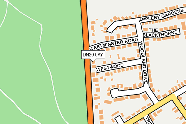
DN20 0AY lies on Appleby Lane in Broughton, Brigg. DN20 0AY is located in the Broughton & Scawby electoral ward, within the unitary authority of North Lincolnshire and the English Parliamentary constituency of Brigg and Goole. The Sub Integrated Care Board (ICB) Location is NHS Humber and North Yorkshire ICB - 03K and the police force is Humberside. This postcode has been in use since January 1980.


GetTheData
Source: OS OpenMap – Local (Ordnance Survey)
Source: OS VectorMap District (Ordnance Survey)
Licence: Open Government Licence (requires attribution)
| Easting | 495588 |
| Northing | 409253 |
| Latitude | 53.571183 |
| Longitude | -0.558008 |
GetTheData
Source: Open Postcode Geo
Licence: Open Government Licence
| Street | Appleby Lane |
| Locality | Broughton |
| Town/City | Brigg |
| Country | England |
| Postcode District | DN20 |
➜ See where DN20 is on a map ➜ Where is Broughton? | |
GetTheData
Source: Land Registry Price Paid Data
Licence: Open Government Licence
Elevation or altitude of DN20 0AY as distance above sea level:
| Metres | Feet | |
|---|---|---|
| Elevation | 50m | 164ft |
Elevation is measured from the approximate centre of the postcode, to the nearest point on an OS contour line from OS Terrain 50, which has contour spacing of ten vertical metres.
➜ How high above sea level am I? Find the elevation of your current position using your device's GPS.
GetTheData
Source: Open Postcode Elevation
Licence: Open Government Licence
| Ward | Broughton & Scawby |
| Constituency | Brigg And Goole |
GetTheData
Source: ONS Postcode Database
Licence: Open Government Licence
2021 15 JAN £255,000 |
2017 3 NOV £238,000 |
2017 12 JUN £195,000 |
96, APPLEBY LANE, BROUGHTON, BRIGG, DN20 0AY 2014 15 AUG £204,000 |
2005 10 AUG £169,950 |
98, APPLEBY LANE, BROUGHTON, BRIGG, DN20 0AY 2002 28 MAR £69,950 |
2002 8 MAR £79,950 |
2000 11 DEC £72,500 |
1996 10 SEP £63,500 |
GetTheData
Source: HM Land Registry Price Paid Data
Licence: Contains HM Land Registry data © Crown copyright and database right 2025. This data is licensed under the Open Government Licence v3.0.
| Appleby Lane | Broughton | 287m |
| Appleby Lane | Broughton | 288m |
| South View | Broughton | 314m |
| South View | Broughton | 321m |
| Dog And Rat (Appleby Lane) | Broughton | 563m |
| Brigg Station | 5.4km |
GetTheData
Source: NaPTAN
Licence: Open Government Licence
| Percentage of properties with Next Generation Access | 100.0% |
| Percentage of properties with Superfast Broadband | 100.0% |
| Percentage of properties with Ultrafast Broadband | 0.0% |
| Percentage of properties with Full Fibre Broadband | 0.0% |
Superfast Broadband is between 30Mbps and 300Mbps
Ultrafast Broadband is > 300Mbps
| Percentage of properties unable to receive 2Mbps | 0.0% |
| Percentage of properties unable to receive 5Mbps | 0.0% |
| Percentage of properties unable to receive 10Mbps | 0.0% |
| Percentage of properties unable to receive 30Mbps | 0.0% |
GetTheData
Source: Ofcom
Licence: Ofcom Terms of Use (requires attribution)
GetTheData
Source: ONS Postcode Database
Licence: Open Government Licence


➜ Get more ratings from the Food Standards Agency
GetTheData
Source: Food Standards Agency
Licence: FSA terms & conditions
| Last Collection | |||
|---|---|---|---|
| Location | Mon-Fri | Sat | Distance |
| Brooklands Broughton | 16:30 | 11:30 | 277m |
| Broughton Post Office | 16:45 | 11:45 | 722m |
| Mill Lane | 16:30 | 11:30 | 997m |
GetTheData
Source: Dracos
Licence: Creative Commons Attribution-ShareAlike
The below table lists the International Territorial Level (ITL) codes (formerly Nomenclature of Territorial Units for Statistics (NUTS) codes) and Local Administrative Units (LAU) codes for DN20 0AY:
| ITL 1 Code | Name |
|---|---|
| TLE | Yorkshire and The Humber |
| ITL 2 Code | Name |
| TLE1 | East Yorkshire and Northern Lincolnshire |
| ITL 3 Code | Name |
| TLE13 | North and North East Lincolnshire |
| LAU 1 Code | Name |
| E06000013 | North Lincolnshire |
GetTheData
Source: ONS Postcode Directory
Licence: Open Government Licence
The below table lists the Census Output Area (OA), Lower Layer Super Output Area (LSOA), and Middle Layer Super Output Area (MSOA) for DN20 0AY:
| Code | Name | |
|---|---|---|
| OA | E00066992 | |
| LSOA | E01013275 | North Lincolnshire 013B |
| MSOA | E02002761 | North Lincolnshire 013 |
GetTheData
Source: ONS Postcode Directory
Licence: Open Government Licence
| DN20 0AU | Westwood | 88m |
| DN20 0AZ | Westminster Road | 97m |
| DN20 0EQ | Woodland Drive | 135m |
| DN20 0AS | Appleby Lane | 144m |
| DN20 0AX | Woodland Drive | 177m |
| DN20 0AT | Appleby Lane | 195m |
| DN20 0EG | South View | 212m |
| DN20 0EE | South View | 244m |
| DN20 0EF | South View | 258m |
| DN20 0BB | The Blackthorns | 258m |
GetTheData
Source: Open Postcode Geo; Land Registry Price Paid Data
Licence: Open Government Licence