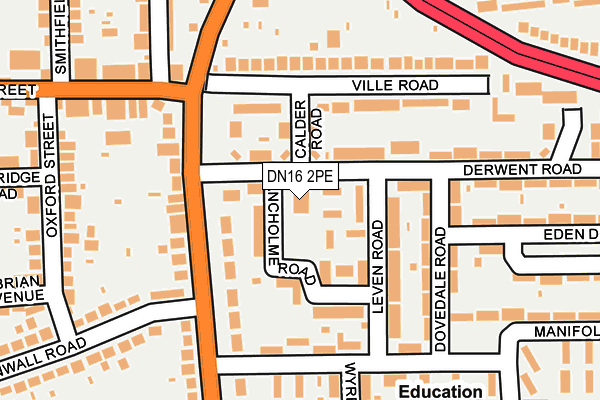
DN16 2PE is located in the Ashby Lakeside electoral ward, within the unitary authority of North Lincolnshire and the English Parliamentary constituency of Scunthorpe. The Sub Integrated Care Board (ICB) Location is NHS Humber and North Yorkshire ICB - 03K and the police force is Humberside. This postcode has been in use since January 1980.


GetTheData
Source: OS OpenMap – Local (Ordnance Survey)
Source: OS VectorMap District (Ordnance Survey)
Licence: Open Government Licence (requires attribution)
| Easting | 490769 |
| Northing | 408530 |
| Latitude | 53.565541 |
| Longitude | -0.630966 |
GetTheData
Source: Open Postcode Geo
Licence: Open Government Licence
| Country | England |
| Postcode District | DN16 |
➜ See where DN16 is on a map ➜ Where is Scunthorpe? | |
GetTheData
Source: Land Registry Price Paid Data
Licence: Open Government Licence
Elevation or altitude of DN16 2PE as distance above sea level:
| Metres | Feet | |
|---|---|---|
| Elevation | 20m | 66ft |
Elevation is measured from the approximate centre of the postcode, to the nearest point on an OS contour line from OS Terrain 50, which has contour spacing of ten vertical metres.
➜ How high above sea level am I? Find the elevation of your current position using your device's GPS.
GetTheData
Source: Open Postcode Elevation
Licence: Open Government Licence
| Ward | Ashby Lakeside |
| Constituency | Scunthorpe |
GetTheData
Source: ONS Postcode Database
Licence: Open Government Licence
| Queen Bess (Derwent Road) | Ashby | 71m |
| Leven Close (Derwent Road) | Ashby | 112m |
| Wryedale Road (Manifold Road) | Ashby | 170m |
| Ville Road (Grange Lane South) | Ashby | 191m |
| Dovedale Road (Manifold Road) | Scunthorpe | 211m |
| Scunthorpe Station | 2.7km |
GetTheData
Source: NaPTAN
Licence: Open Government Licence
GetTheData
Source: ONS Postcode Database
Licence: Open Government Licence


➜ Get more ratings from the Food Standards Agency
GetTheData
Source: Food Standards Agency
Licence: FSA terms & conditions
| Last Collection | |||
|---|---|---|---|
| Location | Mon-Fri | Sat | Distance |
| Manifold Road | 17:30 | 11:45 | 256m |
| Baysdale Road | 17:30 | 11:15 | 327m |
| Bellingham Road | 17:45 | 11:45 | 432m |
GetTheData
Source: Dracos
Licence: Creative Commons Attribution-ShareAlike
The below table lists the International Territorial Level (ITL) codes (formerly Nomenclature of Territorial Units for Statistics (NUTS) codes) and Local Administrative Units (LAU) codes for DN16 2PE:
| ITL 1 Code | Name |
|---|---|
| TLE | Yorkshire and The Humber |
| ITL 2 Code | Name |
| TLE1 | East Yorkshire and Northern Lincolnshire |
| ITL 3 Code | Name |
| TLE13 | North and North East Lincolnshire |
| LAU 1 Code | Name |
| E06000013 | North Lincolnshire |
GetTheData
Source: ONS Postcode Directory
Licence: Open Government Licence
The below table lists the Census Output Area (OA), Lower Layer Super Output Area (LSOA), and Middle Layer Super Output Area (MSOA) for DN16 2PE:
| Code | Name | |
|---|---|---|
| OA | E00066810 | |
| LSOA | E01013238 | North Lincolnshire 015A |
| MSOA | E02002763 | North Lincolnshire 015 |
GetTheData
Source: ONS Postcode Directory
Licence: Open Government Licence
| DN16 2PF | Derwent Road | 50m |
| DN16 2NR | Calder Road | 67m |
| DN16 2NS | Ancholme Road | 84m |
| DN16 3AT | Grange Lane South | 103m |
| DN16 2NT | Leven Road | 118m |
| DN16 3AR | Grange Lane South | 128m |
| DN16 2NW | Ville Road | 150m |
| DN16 2NP | Ville Road | 154m |
| DN16 2PY | Manifold Road | 156m |
| DN16 2PT | Dovedale Road | 161m |
GetTheData
Source: Open Postcode Geo; Land Registry Price Paid Data
Licence: Open Government Licence