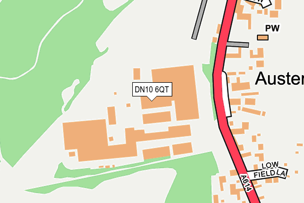
DN10 6QT is located in the Rossington & Bawtry electoral ward, within the metropolitan district of Doncaster and the English Parliamentary constituency of Don Valley. The Sub Integrated Care Board (ICB) Location is NHS South Yorkshire ICB - 02X and the police force is South Yorkshire. This postcode has been in use since January 1980.


GetTheData
Source: OS OpenMap – Local (Ordnance Survey)
Source: OS VectorMap District (Ordnance Survey)
Licence: Open Government Licence (requires attribution)
| Easting | 465952 |
| Northing | 394564 |
| Latitude | 53.443729 |
| Longitude | -1.008532 |
GetTheData
Source: Open Postcode Geo
Licence: Open Government Licence
| Country | England |
| Postcode District | DN10 |
➜ See where DN10 is on a map ➜ Where is Austerfield? | |
GetTheData
Source: Land Registry Price Paid Data
Licence: Open Government Licence
Elevation or altitude of DN10 6QT as distance above sea level:
| Metres | Feet | |
|---|---|---|
| Elevation | 10m | 33ft |
Elevation is measured from the approximate centre of the postcode, to the nearest point on an OS contour line from OS Terrain 50, which has contour spacing of ten vertical metres.
➜ How high above sea level am I? Find the elevation of your current position using your device's GPS.
GetTheData
Source: Open Postcode Elevation
Licence: Open Government Licence
| Ward | Rossington & Bawtry |
| Constituency | Don Valley |
GetTheData
Source: ONS Postcode Database
Licence: Open Government Licence
| St Helenas Church (High Street) | Austerfield | 146m |
| Butten Meadow (High Street) | Austerfield | 157m |
| Pilgrim Rise (High Street) | Austerfield | 353m |
| Pilgrim Rise (High Street) | Austerfield | 361m |
| Low Common Lane (High Street) | Austerfield | 488m |
GetTheData
Source: NaPTAN
Licence: Open Government Licence
GetTheData
Source: ONS Postcode Database
Licence: Open Government Licence


➜ Get more ratings from the Food Standards Agency
GetTheData
Source: Food Standards Agency
Licence: FSA terms & conditions
| Last Collection | |||
|---|---|---|---|
| Location | Mon-Fri | Sat | Distance |
| Austerfield P.o. | 16:45 | 11:15 | 347m |
| Thorne Road | 16:45 | 10:15 | 693m |
| Newington | 16:45 | 10:00 | 945m |
GetTheData
Source: Dracos
Licence: Creative Commons Attribution-ShareAlike
The below table lists the International Territorial Level (ITL) codes (formerly Nomenclature of Territorial Units for Statistics (NUTS) codes) and Local Administrative Units (LAU) codes for DN10 6QT:
| ITL 1 Code | Name |
|---|---|
| TLE | Yorkshire and The Humber |
| ITL 2 Code | Name |
| TLE3 | South Yorkshire |
| ITL 3 Code | Name |
| TLE31 | Barnsley, Doncaster and Rotherham |
| LAU 1 Code | Name |
| E08000017 | Doncaster |
GetTheData
Source: ONS Postcode Directory
Licence: Open Government Licence
The below table lists the Census Output Area (OA), Lower Layer Super Output Area (LSOA), and Middle Layer Super Output Area (MSOA) for DN10 6QT:
| Code | Name | |
|---|---|---|
| OA | E00038528 | |
| LSOA | E01007609 | Doncaster 038B |
| MSOA | E02001576 | Doncaster 038 |
GetTheData
Source: ONS Postcode Directory
Licence: Open Government Licence
| DN10 6QU | High Street | 170m |
| DN10 6QY | Church Lane | 229m |
| DN10 6RH | Low Field Lane | 282m |
| DN10 6RL | Pilgrim Rise | 297m |
| DN10 6SQ | Butten Meadow | 310m |
| DN10 6QS | High Street | 337m |
| DN10 6RZ | Mayflower Court | 418m |
| DN10 6QR | South View | 427m |
| DN10 6RA | Coronation Terrace | 518m |
| DN10 6RF | Low Common Lane | 541m |
GetTheData
Source: Open Postcode Geo; Land Registry Price Paid Data
Licence: Open Government Licence