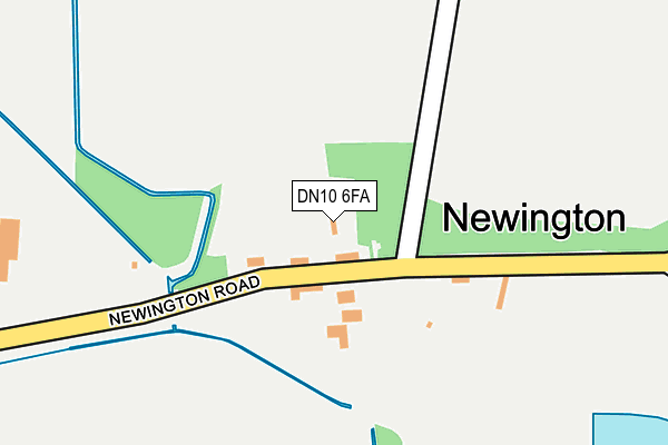
DN10 6FA is located in the Everton electoral ward, within the local authority district of Bassetlaw and the English Parliamentary constituency of Bassetlaw. The Sub Integrated Care Board (ICB) Location is NHS Nottingham and Nottinghamshire ICB - 02Q and the police force is Nottinghamshire. This postcode has been in use since July 2017.


GetTheData
Source: OS OpenMap – Local (Ordnance Survey)
Source: OS VectorMap District (Ordnance Survey)
Licence: Open Government Licence (requires attribution)
| Easting | 468538 |
| Northing | 395669 |
| Latitude | 53.453350 |
| Longitude | -0.969368 |
GetTheData
Source: Open Postcode Geo
Licence: Open Government Licence
| Country | England |
| Postcode District | DN10 |
| ➜ DN10 open data dashboard ➜ See where DN10 is on a map | |
GetTheData
Source: Land Registry Price Paid Data
Licence: Open Government Licence
| Ward | Everton |
| Constituency | Bassetlaw |
GetTheData
Source: ONS Postcode Database
Licence: Open Government Licence
| Bawtry Road | Misson | 630m |
| Bawtry Road | Misson | 632m |
| The Green (Back Lane) | Misson | 712m |
| Demand Responsive Area (Phoneabus) | Misson | 890m |
| High Street | Misson | 899m |
GetTheData
Source: NaPTAN
Licence: Open Government Licence
GetTheData
Source: ONS Postcode Database
Licence: Open Government Licence


➜ Get more ratings from the Food Standards Agency
GetTheData
Source: Food Standards Agency
Licence: FSA terms & conditions
| Last Collection | |||
|---|---|---|---|
| Location | Mon-Fri | Sat | Distance |
| West Street | 16:45 | 09:30 | 714m |
| Newington | 16:45 | 10:00 | 2,412m |
| Austerfield P.o. | 16:45 | 11:15 | 2,529m |
GetTheData
Source: Dracos
Licence: Creative Commons Attribution-ShareAlike
| Facility | Distance |
|---|---|
| Misson Primary School Dame Lane, Misson, Doncaster Grass Pitches | 778m |
| Bawtry Polo Club Bracken Hill Lane, Misson Grass Pitches | 1.4km |
| Bawtry Golf Club Cross Lane, Austerfield, Doncaster Golf | 2km |
GetTheData
Source: Active Places
Licence: Open Government Licence
| School | Phase of Education | Distance |
|---|---|---|
| Misson Primary School Dame Lane, Misson, Doncaster, DN10 6EB | Primary | 784m |
| St Oswald's CofE Academy Silver Birch Grove, Finningley, Doncaster, DN9 3EQ | Primary | 3.8km |
| Bawtry Mayflower Primary School Station Road, Bawtry, Doncaster, DN10 6PU | Primary | 3.8km |
GetTheData
Source: Edubase
Licence: Open Government Licence
| Risk of DN10 6FA flooding from rivers and sea | Low |
| ➜ DN10 6FA flood map | |
GetTheData
Source: Open Flood Risk by Postcode
Licence: Open Government Licence
The below table lists the International Territorial Level (ITL) codes (formerly Nomenclature of Territorial Units for Statistics (NUTS) codes) and Local Administrative Units (LAU) codes for DN10 6FA:
| ITL 1 Code | Name |
|---|---|
| TLF | East Midlands (England) |
| ITL 2 Code | Name |
| TLF1 | Derbyshire and Nottinghamshire |
| ITL 3 Code | Name |
| TLF15 | North Nottinghamshire |
| LAU 1 Code | Name |
| E07000171 | Bassetlaw |
GetTheData
Source: ONS Postcode Directory
Licence: Open Government Licence
The below table lists the Census Output Area (OA), Lower Layer Super Output Area (LSOA), and Middle Layer Super Output Area (MSOA) for DN10 6FA:
| Code | Name | |
|---|---|---|
| OA | E00142783 | |
| LSOA | E01028023 | Bassetlaw 003A |
| MSOA | E02005837 | Bassetlaw 003 |
GetTheData
Source: ONS Postcode Directory
Licence: Open Government Licence
| DN10 6DL | Bawtry Road | 514m |
| DN10 6DN | Coronation Avenue | 569m |
| DN10 6EW | Station Road | 636m |
| DN10 6DW | Bawtry Road | 653m |
| DN10 6DR | The Green | 657m |
| DN10 6BH | Mulberry Court | 676m |
| DN10 6EN | Top Street | 687m |
| DN10 6DS | The Green | 732m |
| DN10 6DP | Bawtry Road | 741m |
| DN10 6DU | The Green | 762m |
GetTheData
Source: Open Postcode Geo; Land Registry Price Paid Data
Licence: Open Government Licence