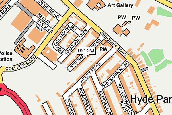
DN1 2AJ lies on Beechfield Road in Doncaster. DN1 2AJ is located in the Town electoral ward, within the metropolitan district of Doncaster and the English Parliamentary constituency of Doncaster Central. The Sub Integrated Care Board (ICB) Location is NHS South Yorkshire ICB - 02X and the police force is South Yorkshire. This postcode has been in use since January 1980.


GetTheData
Source: OS OpenMap – Local (Ordnance Survey)
Source: OS VectorMap District (Ordnance Survey)
Licence: Open Government Licence (requires attribution)
| Easting | 457937 |
| Northing | 402820 |
| Latitude | 53.518869 |
| Longitude | -1.127665 |
GetTheData
Source: Open Postcode Geo
Licence: Open Government Licence
| Street | Beechfield Road |
| Town/City | Doncaster |
| Country | England |
| Postcode District | DN1 |
➜ See where DN1 is on a map ➜ Where is Doncaster? | |
GetTheData
Source: Land Registry Price Paid Data
Licence: Open Government Licence
Elevation or altitude of DN1 2AJ as distance above sea level:
| Metres | Feet | |
|---|---|---|
| Elevation | 20m | 66ft |
Elevation is measured from the approximate centre of the postcode, to the nearest point on an OS contour line from OS Terrain 50, which has contour spacing of ten vertical metres.
➜ How high above sea level am I? Find the elevation of your current position using your device's GPS.
GetTheData
Source: Open Postcode Elevation
Licence: Open Government Licence
| Ward | Town |
| Constituency | Doncaster Central |
GetTheData
Source: ONS Postcode Database
Licence: Open Government Licence
| Apley Road (Chequer Road) | Doncaster Town Centre | 113m |
| Regent Square (South Parade) | Doncaster Town Centre | 284m |
| Regent Square (South Parade) | Doncaster Town Centre | 305m |
| Jarratt Street (Trafford Way) | Hyde Park | 307m |
| Regent Square (South Parade) | Doncaster Town Centre | 310m |
| Doncaster Station | 0.9km |
| Bentley (S Yorks) Station | 3.2km |
GetTheData
Source: NaPTAN
Licence: Open Government Licence
| Percentage of properties with Next Generation Access | 100.0% |
| Percentage of properties with Superfast Broadband | 100.0% |
| Percentage of properties with Ultrafast Broadband | 100.0% |
| Percentage of properties with Full Fibre Broadband | 0.0% |
Superfast Broadband is between 30Mbps and 300Mbps
Ultrafast Broadband is > 300Mbps
| Median download speed | 100.0Mbps |
| Average download speed | 128.3Mbps |
| Maximum download speed | 350.00Mbps |
| Median upload speed | 1.3Mbps |
| Average upload speed | 7.8Mbps |
| Maximum upload speed | 20.00Mbps |
| Percentage of properties unable to receive 2Mbps | 0.0% |
| Percentage of properties unable to receive 5Mbps | 0.0% |
| Percentage of properties unable to receive 10Mbps | 0.0% |
| Percentage of properties unable to receive 30Mbps | 0.0% |
GetTheData
Source: Ofcom
Licence: Ofcom Terms of Use (requires attribution)
Estimated total energy consumption in DN1 2AJ by fuel type, 2015.
| Consumption (kWh) | 337,635 |
|---|---|
| Meter count | 32 |
| Mean (kWh/meter) | 10,551 |
| Median (kWh/meter) | 9,934 |
| Consumption (kWh) | 67,660 |
|---|---|
| Meter count | 29 |
| Mean (kWh/meter) | 2,333 |
| Median (kWh/meter) | 2,084 |
GetTheData
Source: Postcode level gas estimates: 2015 (experimental)
Source: Postcode level electricity estimates: 2015 (experimental)
Licence: Open Government Licence
GetTheData
Source: ONS Postcode Database
Licence: Open Government Licence


➜ Get more ratings from the Food Standards Agency
GetTheData
Source: Food Standards Agency
Licence: FSA terms & conditions
| Last Collection | |||
|---|---|---|---|
| Location | Mon-Fri | Sat | Distance |
| Chequer Road | 18:30 | 11:30 | 117m |
| Hallcross | 18:15 | 11:30 | 297m |
| Waterdale | 18:30 | 11:30 | 318m |
GetTheData
Source: Dracos
Licence: Creative Commons Attribution-ShareAlike
The below table lists the International Territorial Level (ITL) codes (formerly Nomenclature of Territorial Units for Statistics (NUTS) codes) and Local Administrative Units (LAU) codes for DN1 2AJ:
| ITL 1 Code | Name |
|---|---|
| TLE | Yorkshire and The Humber |
| ITL 2 Code | Name |
| TLE3 | South Yorkshire |
| ITL 3 Code | Name |
| TLE31 | Barnsley, Doncaster and Rotherham |
| LAU 1 Code | Name |
| E08000017 | Doncaster |
GetTheData
Source: ONS Postcode Directory
Licence: Open Government Licence
The below table lists the Census Output Area (OA), Lower Layer Super Output Area (LSOA), and Middle Layer Super Output Area (MSOA) for DN1 2AJ:
| Code | Name | |
|---|---|---|
| OA | E00038732 | |
| LSOA | E01007645 | Doncaster 022E |
| MSOA | E02001560 | Doncaster 022 |
GetTheData
Source: ONS Postcode Directory
Licence: Open Government Licence
| DN1 2AH | Beechfield Road | 26m |
| DN1 2DA | Paddock View | 50m |
| DN1 2AX | Apley Road | 64m |
| DN1 2DF | Farrier Close | 84m |
| DN1 2AY | Apley Road | 87m |
| DN1 2AF | Chequer Road | 89m |
| DN1 2AT | Whitburn Road | 107m |
| DN1 2BZ | School House Mews | 111m |
| DN1 2AL | Chequer Road | 114m |
| DN1 3BF | College Road | 131m |
GetTheData
Source: Open Postcode Geo; Land Registry Price Paid Data
Licence: Open Government Licence