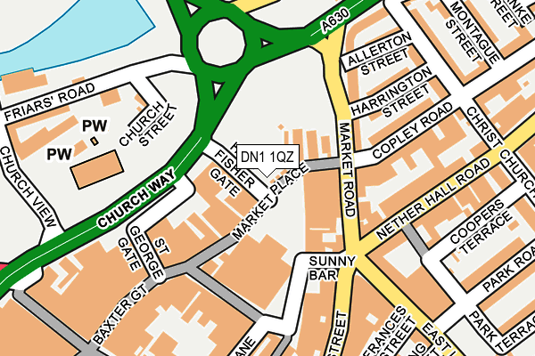
DN1 1QZ lies on High Fisher Gate in Doncaster. DN1 1QZ is located in the Town electoral ward, within the metropolitan district of Doncaster and the English Parliamentary constituency of Doncaster Central. The Sub Integrated Care Board (ICB) Location is NHS South Yorkshire ICB - 02X and the police force is South Yorkshire. This postcode has been in use since January 1980.


GetTheData
Source: OS OpenMap – Local (Ordnance Survey)
Source: OS VectorMap District (Ordnance Survey)
Licence: Open Government Licence (requires attribution)
| Easting | 457564 |
| Northing | 403551 |
| Latitude | 53.525499 |
| Longitude | -1.133158 |
GetTheData
Source: Open Postcode Geo
Licence: Open Government Licence
| Street | High Fisher Gate |
| Town/City | Doncaster |
| Country | England |
| Postcode District | DN1 |
➜ See where DN1 is on a map ➜ Where is Doncaster? | |
GetTheData
Source: Land Registry Price Paid Data
Licence: Open Government Licence
Elevation or altitude of DN1 1QZ as distance above sea level:
| Metres | Feet | |
|---|---|---|
| Elevation | 10m | 33ft |
Elevation is measured from the approximate centre of the postcode, to the nearest point on an OS contour line from OS Terrain 50, which has contour spacing of ten vertical metres.
➜ How high above sea level am I? Find the elevation of your current position using your device's GPS.
GetTheData
Source: Open Postcode Elevation
Licence: Open Government Licence
| Ward | Town |
| Constituency | Doncaster Central |
GetTheData
Source: ONS Postcode Database
Licence: Open Government Licence
| Harrington Street (Market Road) | Doncaster Town Centre | 134m |
| Market Road | Doncaster Town Centre | 144m |
| Church Street (Greyfriars Road) | Doncaster Town Centre | 174m |
| Market Road (Nether Hall Road) | Doncaster Town Centre | 201m |
| Bowers Fold (Silver Street) | Doncaster Town Centre | 239m |
| Doncaster Station | 0.6km |
| Bentley (S Yorks) Station | 2.4km |
| Kirk Sandall Station | 5.8km |
GetTheData
Source: NaPTAN
Licence: Open Government Licence
GetTheData
Source: ONS Postcode Database
Licence: Open Government Licence


➜ Get more ratings from the Food Standards Agency
GetTheData
Source: Food Standards Agency
Licence: FSA terms & conditions
| Last Collection | |||
|---|---|---|---|
| Location | Mon-Fri | Sat | Distance |
| Market Place | 18:30 | 11:45 | 144m |
| Priory Place | 18:30 | 13:30 | 277m |
| Tesco North Bridge | 18:30 | 12:15 | 302m |
GetTheData
Source: Dracos
Licence: Creative Commons Attribution-ShareAlike
The below table lists the International Territorial Level (ITL) codes (formerly Nomenclature of Territorial Units for Statistics (NUTS) codes) and Local Administrative Units (LAU) codes for DN1 1QZ:
| ITL 1 Code | Name |
|---|---|
| TLE | Yorkshire and The Humber |
| ITL 2 Code | Name |
| TLE3 | South Yorkshire |
| ITL 3 Code | Name |
| TLE31 | Barnsley, Doncaster and Rotherham |
| LAU 1 Code | Name |
| E08000017 | Doncaster |
GetTheData
Source: ONS Postcode Directory
Licence: Open Government Licence
The below table lists the Census Output Area (OA), Lower Layer Super Output Area (LSOA), and Middle Layer Super Output Area (MSOA) for DN1 1QZ:
| Code | Name | |
|---|---|---|
| OA | E00038754 | |
| LSOA | E01007655 | Doncaster 022F |
| MSOA | E02001560 | Doncaster 022 |
GetTheData
Source: ONS Postcode Directory
Licence: Open Government Licence
| DN1 1LQ | Market Place | 56m |
| DN1 1LG | Baxter Gate | 113m |
| DN1 1LP | Market Road | 148m |
| DN1 1NJ | Market Place | 151m |
| DN1 1LD | Baxter Gate | 177m |
| DN1 1LW | Market Road | 182m |
| DN1 2PH | Nether Hall Road | 186m |
| DN1 1NE | Market Place | 188m |
| DN1 2PF | Copley Road | 192m |
| DN1 1JL | Silver Street | 196m |
GetTheData
Source: Open Postcode Geo; Land Registry Price Paid Data
Licence: Open Government Licence