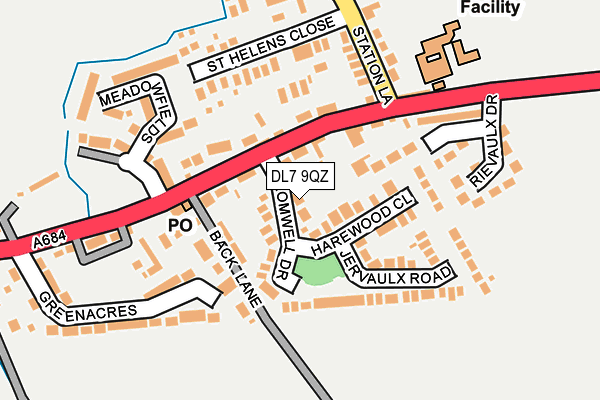
DL7 9QZ lies on Cromwell Drive in Morton On Swale, Northallerton. DL7 9QZ is located in the Morton-on-Swale & Appleton Wiske electoral ward, within the unitary authority of North Yorkshire and the English Parliamentary constituency of Richmond (Yorks). The Sub Integrated Care Board (ICB) Location is NHS Humber and North Yorkshire ICB - 42D and the police force is North Yorkshire. This postcode has been in use since January 1980.


GetTheData
Source: OS OpenMap – Local (Ordnance Survey)
Source: OS VectorMap District (Ordnance Survey)
Licence: Open Government Licence (requires attribution)
| Easting | 432698 |
| Northing | 491963 |
| Latitude | 54.322206 |
| Longitude | -1.498797 |
GetTheData
Source: Open Postcode Geo
Licence: Open Government Licence
| Street | Cromwell Drive |
| Locality | Morton On Swale |
| Town/City | Northallerton |
| Country | England |
| Postcode District | DL7 |
➜ See where DL7 is on a map ➜ Where is Morton-on-Swale? | |
GetTheData
Source: Land Registry Price Paid Data
Licence: Open Government Licence
Elevation or altitude of DL7 9QZ as distance above sea level:
| Metres | Feet | |
|---|---|---|
| Elevation | 40m | 131ft |
Elevation is measured from the approximate centre of the postcode, to the nearest point on an OS contour line from OS Terrain 50, which has contour spacing of ten vertical metres.
➜ How high above sea level am I? Find the elevation of your current position using your device's GPS.
GetTheData
Source: Open Postcode Elevation
Licence: Open Government Licence
| Ward | Morton-on-swale & Appleton Wiske |
| Constituency | Richmond (Yorks) |
GetTheData
Source: ONS Postcode Database
Licence: Open Government Licence
| Cromwell Drive (A684) | Morton-on-swale | 55m |
| Cromwell Drive (A684) | Morton-on-swale | 66m |
| The Dales School (A684) | Morton-on-swale | 249m |
| Morton Grange (A684) | Morton-on-swale | 319m |
| Swaledale Arms (A684) | Morton-on-swale | 471m |
| Northallerton Station | 3.9km |
GetTheData
Source: NaPTAN
Licence: Open Government Licence
| Percentage of properties with Next Generation Access | 100.0% |
| Percentage of properties with Superfast Broadband | 100.0% |
| Percentage of properties with Ultrafast Broadband | 0.0% |
| Percentage of properties with Full Fibre Broadband | 0.0% |
Superfast Broadband is between 30Mbps and 300Mbps
Ultrafast Broadband is > 300Mbps
| Median download speed | 40.0Mbps |
| Average download speed | 32.6Mbps |
| Maximum download speed | 70.85Mbps |
| Median upload speed | 10.0Mbps |
| Average upload speed | 8.5Mbps |
| Maximum upload speed | 19.53Mbps |
| Percentage of properties unable to receive 2Mbps | 0.0% |
| Percentage of properties unable to receive 5Mbps | 0.0% |
| Percentage of properties unable to receive 10Mbps | 0.0% |
| Percentage of properties unable to receive 30Mbps | 0.0% |
GetTheData
Source: Ofcom
Licence: Ofcom Terms of Use (requires attribution)
GetTheData
Source: ONS Postcode Database
Licence: Open Government Licence


➜ Get more ratings from the Food Standards Agency
GetTheData
Source: Food Standards Agency
Licence: FSA terms & conditions
| Last Collection | |||
|---|---|---|---|
| Location | Mon-Fri | Sat | Distance |
| Morton On Swale | 17:15 | 11:15 | 118m |
| Ainderby Steeple | 17:15 | 11:15 | 678m |
| Warlaby | 16:15 | 10:45 | 2,285m |
GetTheData
Source: Dracos
Licence: Creative Commons Attribution-ShareAlike
The below table lists the International Territorial Level (ITL) codes (formerly Nomenclature of Territorial Units for Statistics (NUTS) codes) and Local Administrative Units (LAU) codes for DL7 9QZ:
| ITL 1 Code | Name |
|---|---|
| TLE | Yorkshire and The Humber |
| ITL 2 Code | Name |
| TLE2 | North Yorkshire |
| ITL 3 Code | Name |
| TLE22 | North Yorkshire CC |
| LAU 1 Code | Name |
| E07000164 | Hambleton |
GetTheData
Source: ONS Postcode Directory
Licence: Open Government Licence
The below table lists the Census Output Area (OA), Lower Layer Super Output Area (LSOA), and Middle Layer Super Output Area (MSOA) for DL7 9QZ:
| Code | Name | |
|---|---|---|
| OA | E00140553 | |
| LSOA | E01027604 | Hambleton 005B |
| MSOA | E02005754 | Hambleton 005 |
GetTheData
Source: ONS Postcode Directory
Licence: Open Government Licence
| DL7 9QY | Cromwell Drive | 62m |
| DL7 9RB | 77m | |
| DL7 9QX | 80m | |
| DL7 9QS | 81m | |
| DL7 9RD | Swale View | 82m |
| DL7 9QU | Orchard Place | 92m |
| DL7 9QT | Harewood Close | 92m |
| DL7 9TE | St Helens Drive | 109m |
| DL7 9RA | Jervaulx Road | 127m |
| DL7 9QP | South View | 147m |
GetTheData
Source: Open Postcode Geo; Land Registry Price Paid Data
Licence: Open Government Licence