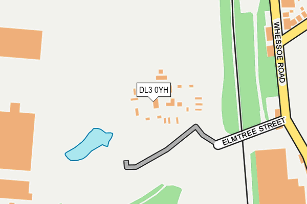
DL3 0YH is located in the Brinkburn & Faverdale electoral ward, within the unitary authority of Darlington and the English Parliamentary constituency of Darlington. The Sub Integrated Care Board (ICB) Location is NHS North East and North Cumbria ICB - 16C and the police force is Durham. This postcode has been in use since July 1983.


GetTheData
Source: OS OpenMap – Local (Ordnance Survey)
Source: OS VectorMap District (Ordnance Survey)
Licence: Open Government Licence (requires attribution)
| Easting | 428341 |
| Northing | 516630 |
| Latitude | 54.544152 |
| Longitude | -1.563440 |
GetTheData
Source: Open Postcode Geo
Licence: Open Government Licence
| Country | England |
| Postcode District | DL3 |
➜ See where DL3 is on a map | |
GetTheData
Source: Land Registry Price Paid Data
Licence: Open Government Licence
Elevation or altitude of DL3 0YH as distance above sea level:
| Metres | Feet | |
|---|---|---|
| Elevation | 60m | 197ft |
Elevation is measured from the approximate centre of the postcode, to the nearest point on an OS contour line from OS Terrain 50, which has contour spacing of ten vertical metres.
➜ How high above sea level am I? Find the elevation of your current position using your device's GPS.
GetTheData
Source: Open Postcode Elevation
Licence: Open Government Licence
| Ward | Brinkburn & Faverdale |
| Constituency | Darlington |
GetTheData
Source: ONS Postcode Database
Licence: Open Government Licence
| Elmtree Street (Whessoe Road) | Rise Carr | 234m |
| North Park (Whessoe Road) | Rise Carr | 236m |
| Elmtree Street (Whessoe Road) | Rise Carr | 278m |
| North Park (Longfield Road) | Harrowgate Hill | 309m |
| Prospect Place (Whessoe Road) | Rise Carr | 400m |
| North Road Station | 1.1km |
| Darlington Station | 2.8km |
GetTheData
Source: NaPTAN
Licence: Open Government Licence
| Percentage of properties with Next Generation Access | 100.0% |
| Percentage of properties with Superfast Broadband | 100.0% |
| Percentage of properties with Ultrafast Broadband | 0.0% |
| Percentage of properties with Full Fibre Broadband | 0.0% |
Superfast Broadband is between 30Mbps and 300Mbps
Ultrafast Broadband is > 300Mbps
| Median download speed | 21.9Mbps |
| Average download speed | 23.9Mbps |
| Maximum download speed | 39.81Mbps |
| Median upload speed | 4.0Mbps |
| Average upload speed | 4.5Mbps |
| Maximum upload speed | 9.75Mbps |
| Percentage of properties unable to receive 2Mbps | 0.0% |
| Percentage of properties unable to receive 5Mbps | 0.0% |
| Percentage of properties unable to receive 10Mbps | 0.0% |
| Percentage of properties unable to receive 30Mbps | 0.0% |
GetTheData
Source: Ofcom
Licence: Ofcom Terms of Use (requires attribution)
GetTheData
Source: ONS Postcode Database
Licence: Open Government Licence


➜ Get more ratings from the Food Standards Agency
GetTheData
Source: Food Standards Agency
Licence: FSA terms & conditions
| Last Collection | |||
|---|---|---|---|
| Location | Mon-Fri | Sat | Distance |
| Westmoreland Street | 17:30 | 11:15 | 457m |
| Longfield Road | 17:30 | 11:00 | 611m |
| Wayland Terrace | 17:30 | 11:00 | 771m |
GetTheData
Source: Dracos
Licence: Creative Commons Attribution-ShareAlike
The below table lists the International Territorial Level (ITL) codes (formerly Nomenclature of Territorial Units for Statistics (NUTS) codes) and Local Administrative Units (LAU) codes for DL3 0YH:
| ITL 1 Code | Name |
|---|---|
| TLC | North East (England) |
| ITL 2 Code | Name |
| TLC1 | Tees Valley and Durham |
| ITL 3 Code | Name |
| TLC13 | Darlington |
| LAU 1 Code | Name |
| E06000005 | Darlington |
GetTheData
Source: ONS Postcode Directory
Licence: Open Government Licence
The below table lists the Census Output Area (OA), Lower Layer Super Output Area (LSOA), and Middle Layer Super Output Area (MSOA) for DL3 0YH:
| Code | Name | |
|---|---|---|
| OA | E00062133 | |
| LSOA | E01033482 | Darlington 001F |
| MSOA | E02002559 | Darlington 001 |
GetTheData
Source: ONS Postcode Directory
Licence: Open Government Licence
| DL3 0RP | Whessoe Road | 317m |
| DL3 0RL | Ianson Street | 338m |
| DL3 0RR | Longfield Road | 348m |
| DL3 0QY | Carr Side | 363m |
| DL3 0RB | Spring Hill | 365m |
| DL3 0RZ | Hartington Way | 380m |
| DL3 0RU | Longfield Road | 384m |
| DL3 0RS | Farnham Drive | 387m |
| DL3 0RD | Whessoe Road | 391m |
| DL3 0RQ | Spring Hill | 395m |
GetTheData
Source: Open Postcode Geo; Land Registry Price Paid Data
Licence: Open Government Licence