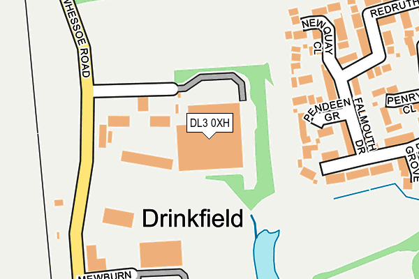
DL3 0XH is located in the Harrowgate Hill electoral ward, within the unitary authority of Darlington and the English Parliamentary constituency of Darlington. The Sub Integrated Care Board (ICB) Location is NHS North East and North Cumbria ICB - 16C and the police force is Durham. This postcode has been in use since January 1980.


GetTheData
Source: OS OpenMap – Local (Ordnance Survey)
Source: OS VectorMap District (Ordnance Survey)
Licence: Open Government Licence (requires attribution)
| Easting | 428652 |
| Northing | 517634 |
| Latitude | 54.553146 |
| Longitude | -1.558527 |
GetTheData
Source: Open Postcode Geo
Licence: Open Government Licence
| Country | England |
| Postcode District | DL3 |
➜ See where DL3 is on a map ➜ Where is Darlington? | |
GetTheData
Source: Land Registry Price Paid Data
Licence: Open Government Licence
Elevation or altitude of DL3 0XH as distance above sea level:
| Metres | Feet | |
|---|---|---|
| Elevation | 70m | 230ft |
Elevation is measured from the approximate centre of the postcode, to the nearest point on an OS contour line from OS Terrain 50, which has contour spacing of ten vertical metres.
➜ How high above sea level am I? Find the elevation of your current position using your device's GPS.
GetTheData
Source: Open Postcode Elevation
Licence: Open Government Licence
| Ward | Harrowgate Hill |
| Constituency | Darlington |
GetTheData
Source: ONS Postcode Database
Licence: Open Government Licence
| Hayle Court (Camborne Drive) | Harrowgate Farm | 464m |
| Princess Road | Harrowgate Hill | 560m |
| Alwyn Road | Harrowgate Hill | 625m |
| Longfield Academy (Longfield Road) | Harrowgate Hill | 686m |
| Vaughan Street (Longfield Road) | Harrowgate Hill | 687m |
| North Road Station | 1.9km |
| Darlington Station | 3.7km |
| Heighington Station | 5.1km |
GetTheData
Source: NaPTAN
Licence: Open Government Licence
GetTheData
Source: ONS Postcode Database
Licence: Open Government Licence


➜ Get more ratings from the Food Standards Agency
GetTheData
Source: Food Standards Agency
Licence: FSA terms & conditions
| Last Collection | |||
|---|---|---|---|
| Location | Mon-Fri | Sat | Distance |
| Burtree Lane | 17:30 | 11:00 | 557m |
| Longfield Road | 17:30 | 11:00 | 728m |
| North End P.o. Mayfair Road | 17:30 | 11:30 | 792m |
GetTheData
Source: Dracos
Licence: Creative Commons Attribution-ShareAlike
The below table lists the International Territorial Level (ITL) codes (formerly Nomenclature of Territorial Units for Statistics (NUTS) codes) and Local Administrative Units (LAU) codes for DL3 0XH:
| ITL 1 Code | Name |
|---|---|
| TLC | North East (England) |
| ITL 2 Code | Name |
| TLC1 | Tees Valley and Durham |
| ITL 3 Code | Name |
| TLC13 | Darlington |
| LAU 1 Code | Name |
| E06000005 | Darlington |
GetTheData
Source: ONS Postcode Directory
Licence: Open Government Licence
The below table lists the Census Output Area (OA), Lower Layer Super Output Area (LSOA), and Middle Layer Super Output Area (MSOA) for DL3 0XH:
| Code | Name | |
|---|---|---|
| OA | E00062156 | |
| LSOA | E01032546 | Darlington 002F |
| MSOA | E02002560 | Darlington 002 |
GetTheData
Source: ONS Postcode Directory
Licence: Open Government Licence
| DL3 0XE | Whessoe Road | 136m |
| DL3 0ZZ | Pendeen Grove | 139m |
| DL3 0ZS | Falmouth Drive | 187m |
| DL3 0ZR | Marazion Drive | 218m |
| DL3 0ZT | Newquay Close | 221m |
| DL3 0ZW | Penryn Close | 279m |
| DL3 0ZP | Bodmin Grove | 311m |
| DL3 0ZU | Redruth Drive | 313m |
| DL3 0ZN | Newlyn Drive | 357m |
| DL3 0ZL | Helston Close | 372m |
GetTheData
Source: Open Postcode Geo; Land Registry Price Paid Data
Licence: Open Government Licence