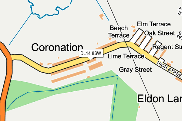
DL14 8SW lies on Margaret Terrace in Coronation, Bishop Auckland. DL14 8SW is located in the Shildon and Dene Valley electoral ward, within the unitary authority of County Durham and the English Parliamentary constituency of Bishop Auckland. The Sub Integrated Care Board (ICB) Location is NHS North East and North Cumbria ICB - 84H and the police force is Durham. This postcode has been in use since January 1980.


GetTheData
Source: OS OpenMap – Local (Ordnance Survey)
Source: OS VectorMap District (Ordnance Survey)
Licence: Open Government Licence (requires attribution)
| Easting | 422399 |
| Northing | 527840 |
| Latitude | 54.645177 |
| Longitude | -1.654427 |
GetTheData
Source: Open Postcode Geo
Licence: Open Government Licence
| Street | Margaret Terrace |
| Locality | Coronation |
| Town/City | Bishop Auckland |
| Country | England |
| Postcode District | DL14 |
➜ See where DL14 is on a map ➜ Where is Coronation? | |
GetTheData
Source: Land Registry Price Paid Data
Licence: Open Government Licence
Elevation or altitude of DL14 8SW as distance above sea level:
| Metres | Feet | |
|---|---|---|
| Elevation | 100m | 328ft |
Elevation is measured from the approximate centre of the postcode, to the nearest point on an OS contour line from OS Terrain 50, which has contour spacing of ten vertical metres.
➜ How high above sea level am I? Find the elevation of your current position using your device's GPS.
GetTheData
Source: Open Postcode Elevation
Licence: Open Government Licence
| Ward | Shildon And Dene Valley |
| Constituency | Bishop Auckland |
GetTheData
Source: ONS Postcode Database
Licence: Open Government Licence
| Margaret Terrace | Eldon Lane | 19m |
| Margaret Terrace | Eldon Lane | 34m |
| Oxford Street (High Street) | Eldon Lane | 183m |
| Oxford Street (High Street) | Eldon Lane | 210m |
| Rosemount Garage (Rosemount Road) | South Church | 292m |
| Bishop Auckland Station | 2km |
| Shildon Station | 2.4km |
| Newton Aycliffe Station | 5.5km |
GetTheData
Source: NaPTAN
Licence: Open Government Licence
| Percentage of properties with Next Generation Access | 0.0% |
| Percentage of properties with Superfast Broadband | 0.0% |
| Percentage of properties with Ultrafast Broadband | 0.0% |
| Percentage of properties with Full Fibre Broadband | 0.0% |
Superfast Broadband is between 30Mbps and 300Mbps
Ultrafast Broadband is > 300Mbps
| Percentage of properties unable to receive 2Mbps | 0.0% |
| Percentage of properties unable to receive 5Mbps | 0.0% |
| Percentage of properties unable to receive 10Mbps | 0.0% |
| Percentage of properties unable to receive 30Mbps | 100.0% |
GetTheData
Source: Ofcom
Licence: Ofcom Terms of Use (requires attribution)
Estimated total energy consumption in DL14 8SW by fuel type, 2015.
| Consumption (kWh) | 50,729 |
|---|---|
| Meter count | 7 |
| Mean (kWh/meter) | 7,247 |
| Median (kWh/meter) | 5,436 |
| Consumption (kWh) | 13,166 |
|---|---|
| Meter count | 8 |
| Mean (kWh/meter) | 1,646 |
| Median (kWh/meter) | 1,810 |
GetTheData
Source: Postcode level gas estimates: 2015 (experimental)
Source: Postcode level electricity estimates: 2015 (experimental)
Licence: Open Government Licence
GetTheData
Source: ONS Postcode Database
Licence: Open Government Licence


➜ Get more ratings from the Food Standards Agency
GetTheData
Source: Food Standards Agency
Licence: FSA terms & conditions
| Last Collection | |||
|---|---|---|---|
| Location | Mon-Fri | Sat | Distance |
| Rosemount | 17:30 | 11:15 | 488m |
| South Church | 17:30 | 11:15 | 672m |
| South Church Post Office | 17:30 | 11:15 | 929m |
GetTheData
Source: Dracos
Licence: Creative Commons Attribution-ShareAlike
The below table lists the International Territorial Level (ITL) codes (formerly Nomenclature of Territorial Units for Statistics (NUTS) codes) and Local Administrative Units (LAU) codes for DL14 8SW:
| ITL 1 Code | Name |
|---|---|
| TLC | North East (England) |
| ITL 2 Code | Name |
| TLC1 | Tees Valley and Durham |
| ITL 3 Code | Name |
| TLC14 | Durham |
| LAU 1 Code | Name |
| E06000047 | County Durham |
GetTheData
Source: ONS Postcode Directory
Licence: Open Government Licence
The below table lists the Census Output Area (OA), Lower Layer Super Output Area (LSOA), and Middle Layer Super Output Area (MSOA) for DL14 8SW:
| Code | Name | |
|---|---|---|
| OA | E00105985 | |
| LSOA | E01020880 | County Durham 055D |
| MSOA | E02004352 | County Durham 055 |
GetTheData
Source: ONS Postcode Directory
Licence: Open Government Licence
| DL14 8SN | John Terrace | 25m |
| DL14 8SP | Mary Terrace | 53m |
| DL14 8SH | James Terrace | 83m |
| DL14 8SJ | David Terrace | 85m |
| DL14 8SL | Richard Terrace | 87m |
| DL14 8SS | Beech Terrace | 158m |
| DL14 8SR | Elm Terrace | 177m |
| DL14 8SX | Lime Terrace | 185m |
| DL14 8ST | Oak Street | 190m |
| DL14 8SU | Regent Street | 200m |
GetTheData
Source: Open Postcode Geo; Land Registry Price Paid Data
Licence: Open Government Licence