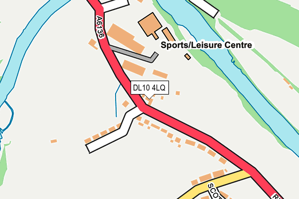
DL10 4LQ is located in the Hipswell & Colburn electoral ward, within the unitary authority of North Yorkshire and the English Parliamentary constituency of Richmond (Yorks). The Sub Integrated Care Board (ICB) Location is NHS Humber and North Yorkshire ICB - 42D and the police force is North Yorkshire. This postcode has been in use since January 1980.


GetTheData
Source: OS OpenMap – Local (Ordnance Survey)
Source: OS VectorMap District (Ordnance Survey)
Licence: Open Government Licence (requires attribution)
| Easting | 417710 |
| Northing | 500731 |
| Latitude | 54.401751 |
| Longitude | -1.728710 |
GetTheData
Source: Open Postcode Geo
Licence: Open Government Licence
| Country | England |
| Postcode District | DL10 |
➜ See where DL10 is on a map ➜ Where is Richmond? | |
GetTheData
Source: Land Registry Price Paid Data
Licence: Open Government Licence
Elevation or altitude of DL10 4LQ as distance above sea level:
| Metres | Feet | |
|---|---|---|
| Elevation | 100m | 328ft |
Elevation is measured from the approximate centre of the postcode, to the nearest point on an OS contour line from OS Terrain 50, which has contour spacing of ten vertical metres.
➜ How high above sea level am I? Find the elevation of your current position using your device's GPS.
GetTheData
Source: Open Postcode Elevation
Licence: Open Government Licence
| Ward | Hipswell & Colburn |
| Constituency | Richmond (Yorks) |
GetTheData
Source: ONS Postcode Database
Licence: Open Government Licence
| Old Station (A6136) | Sleegill | 178m |
| Old Station (A6136) | Sleegill | 188m |
| Rimington Avenue (Theakston Lane) | Holly Hill | 200m |
| Rimington Avenue (Theakston Lane) | Holly Hill | 249m |
| The Avenue (Easby Low Road) | Sleegill | 391m |
GetTheData
Source: NaPTAN
Licence: Open Government Licence
| Percentage of properties with Next Generation Access | 100.0% |
| Percentage of properties with Superfast Broadband | 100.0% |
| Percentage of properties with Ultrafast Broadband | 0.0% |
| Percentage of properties with Full Fibre Broadband | 0.0% |
Superfast Broadband is between 30Mbps and 300Mbps
Ultrafast Broadband is > 300Mbps
| Percentage of properties unable to receive 2Mbps | 0.0% |
| Percentage of properties unable to receive 5Mbps | 0.0% |
| Percentage of properties unable to receive 10Mbps | 0.0% |
| Percentage of properties unable to receive 30Mbps | 0.0% |
GetTheData
Source: Ofcom
Licence: Ofcom Terms of Use (requires attribution)
GetTheData
Source: ONS Postcode Database
Licence: Open Government Licence


➜ Get more ratings from the Food Standards Agency
GetTheData
Source: Food Standards Agency
Licence: FSA terms & conditions
| Last Collection | |||
|---|---|---|---|
| Location | Mon-Fri | Sat | Distance |
| Remington Avenue | 17:30 | 08:30 | 236m |
| Woolworths, Market Place | 17:30 | 11:30 | 496m |
| Maison Dieu | 17:15 | 11:45 | 568m |
GetTheData
Source: Dracos
Licence: Creative Commons Attribution-ShareAlike
The below table lists the International Territorial Level (ITL) codes (formerly Nomenclature of Territorial Units for Statistics (NUTS) codes) and Local Administrative Units (LAU) codes for DL10 4LQ:
| ITL 1 Code | Name |
|---|---|
| TLE | Yorkshire and The Humber |
| ITL 2 Code | Name |
| TLE2 | North Yorkshire |
| ITL 3 Code | Name |
| TLE22 | North Yorkshire CC |
| LAU 1 Code | Name |
| E07000166 | Richmondshire |
GetTheData
Source: ONS Postcode Directory
Licence: Open Government Licence
The below table lists the Census Output Area (OA), Lower Layer Super Output Area (LSOA), and Middle Layer Super Output Area (MSOA) for DL10 4LQ:
| Code | Name | |
|---|---|---|
| OA | E00141349 | |
| LSOA | E01027754 | Richmondshire 004C |
| MSOA | E02005785 | Richmondshire 004 |
GetTheData
Source: ONS Postcode Directory
Licence: Open Government Licence
| DL10 4LW | River View | 59m |
| DL10 4LF | Station Cottages | 65m |
| DL10 4LE | 85m | |
| DL10 4LH | Priory Villas | 104m |
| DL10 4LJ | Rimington Avenue | 139m |
| DL10 4LL | Theakston Lane | 181m |
| DL10 4LB | Station Cottages | 229m |
| DL10 4LN | Scots Dyke Terrace | 285m |
| DL10 7AY | Maison Dieu | 410m |
| DL10 4JR | Riverside Road | 429m |
GetTheData
Source: Open Postcode Geo; Land Registry Price Paid Data
Licence: Open Government Licence