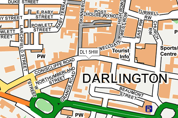
DL1 5HW lies on Blackwellgate in Darlington. DL1 5HW is located in the Park East electoral ward, within the unitary authority of Darlington and the English Parliamentary constituency of Darlington. The Sub Integrated Care Board (ICB) Location is NHS North East and North Cumbria ICB - 16C and the police force is Durham. This postcode has been in use since January 1980.


GetTheData
Source: OS OpenMap – Local (Ordnance Survey)
Source: OS VectorMap District (Ordnance Survey)
Licence: Open Government Licence (requires attribution)
| Easting | 428761 |
| Northing | 514349 |
| Latitude | 54.523630 |
| Longitude | -1.557170 |
GetTheData
Source: Open Postcode Geo
Licence: Open Government Licence
| Street | Blackwellgate |
| Town/City | Darlington |
| Country | England |
| Postcode District | DL1 |
➜ See where DL1 is on a map ➜ Where is Darlington? | |
GetTheData
Source: Land Registry Price Paid Data
Licence: Open Government Licence
Elevation or altitude of DL1 5HW as distance above sea level:
| Metres | Feet | |
|---|---|---|
| Elevation | 50m | 164ft |
Elevation is measured from the approximate centre of the postcode, to the nearest point on an OS contour line from OS Terrain 50, which has contour spacing of ten vertical metres.
➜ How high above sea level am I? Find the elevation of your current position using your device's GPS.
GetTheData
Source: Open Postcode Elevation
Licence: Open Government Licence
| Ward | Park East |
| Constituency | Darlington |
GetTheData
Source: ONS Postcode Database
Licence: Open Government Licence
| Houndgate | Darlington | 15m |
| Prebend Row | Darlington | 218m |
| Tubwell Row | Darlington | 220m |
| Dolphin Centre (Feethams) | Darlington | 228m |
| Town Hall (Feethams) | Darlington | 231m |
| Darlington Station | 0.7km |
| North Road Station | 1.4km |
GetTheData
Source: NaPTAN
Licence: Open Government Licence
GetTheData
Source: ONS Postcode Database
Licence: Open Government Licence


➜ Get more ratings from the Food Standards Agency
GetTheData
Source: Food Standards Agency
Licence: FSA terms & conditions
| Last Collection | |||
|---|---|---|---|
| Location | Mon-Fri | Sat | Distance |
| Blackwellgate | 17:45 | 11:45 | 6m |
| Victoria Road | 17:30 | 11:00 | 146m |
| High Row A | 18:30 | 11:45 | 150m |
GetTheData
Source: Dracos
Licence: Creative Commons Attribution-ShareAlike
The below table lists the International Territorial Level (ITL) codes (formerly Nomenclature of Territorial Units for Statistics (NUTS) codes) and Local Administrative Units (LAU) codes for DL1 5HW:
| ITL 1 Code | Name |
|---|---|
| TLC | North East (England) |
| ITL 2 Code | Name |
| TLC1 | Tees Valley and Durham |
| ITL 3 Code | Name |
| TLC13 | Darlington |
| LAU 1 Code | Name |
| E06000005 | Darlington |
GetTheData
Source: ONS Postcode Directory
Licence: Open Government Licence
The below table lists the Census Output Area (OA), Lower Layer Super Output Area (LSOA), and Middle Layer Super Output Area (MSOA) for DL1 5HW:
| Code | Name | |
|---|---|---|
| OA | E00062058 | |
| LSOA | E01033484 | Darlington 008F |
| MSOA | E02002566 | Darlington 008 |
GetTheData
Source: ONS Postcode Directory
Licence: Open Government Licence
| DL1 5HL | Blackwellgate | 33m |
| DL1 5HG | Blackwellgate | 39m |
| DL1 5RL | Houndgate | 49m |
| DL1 5NA | Grange Road | 60m |
| DL3 7NJ | Skinnergate | 93m |
| DL3 7LX | Skinnergate | 97m |
| DL1 5QP | Chancery Lane | 102m |
| DL3 7QG | Clarks Yard | 113m |
| DL1 5PD | Wellington Court Mews | 116m |
| DL1 5RH | Houndgate | 117m |
GetTheData
Source: Open Postcode Geo; Land Registry Price Paid Data
Licence: Open Government Licence