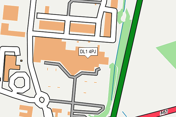
DL1 4PJ is located in the Sadberge & Middleton St George electoral ward, within the unitary authority of Darlington and the English Parliamentary constituency of Sedgefield. The Sub Integrated Care Board (ICB) Location is NHS North East and North Cumbria ICB - 16C and the police force is Durham. This postcode has been in use since January 1995.


GetTheData
Source: OS OpenMap – Local (Ordnance Survey)
Source: OS VectorMap District (Ordnance Survey)
Licence: Open Government Licence (requires attribution)
| Easting | 432373 |
| Northing | 514039 |
| Latitude | 54.520628 |
| Longitude | -1.501402 |
GetTheData
Source: Open Postcode Geo
Licence: Open Government Licence
| Country | England |
| Postcode District | DL1 |
➜ See where DL1 is on a map ➜ Where is Darlington? | |
GetTheData
Source: Land Registry Price Paid Data
Licence: Open Government Licence
Elevation or altitude of DL1 4PJ as distance above sea level:
| Metres | Feet | |
|---|---|---|
| Elevation | 50m | 164ft |
Elevation is measured from the approximate centre of the postcode, to the nearest point on an OS contour line from OS Terrain 50, which has contour spacing of ten vertical metres.
➜ How high above sea level am I? Find the elevation of your current position using your device's GPS.
GetTheData
Source: Open Postcode Elevation
Licence: Open Government Licence
| Ward | Sadberge & Middleton St George |
| Constituency | Sedgefield |
GetTheData
Source: ONS Postcode Database
Licence: Open Government Licence
| Morrisons (Morton Park Way) | Morton Park - Darlington | 102m |
| Morton Palms (Yarm Road) | Morton Park - Darlington | 313m |
| Morton Palms (Yarm Road) | Morton Park - Darlington | 361m |
| Pioneer House (Alderman Best Way) | Morton Palms | 362m |
| Wild Road (Lingfield Way) | Lingfield | 387m |
| Dinsdale Station | 2.3km |
| Darlington Station | 3km |
| North Road Station | 3.8km |
GetTheData
Source: NaPTAN
Licence: Open Government Licence
| Median download speed | 1.4Mbps |
| Average download speed | 2.1Mbps |
| Maximum download speed | 5.02Mbps |
| Median upload speed | 0.6Mbps |
| Average upload speed | 0.6Mbps |
| Maximum upload speed | 1.02Mbps |
GetTheData
Source: Ofcom
Licence: Ofcom Terms of Use (requires attribution)
GetTheData
Source: ONS Postcode Database
Licence: Open Government Licence

➜ Get more ratings from the Food Standards Agency
GetTheData
Source: Food Standards Agency
Licence: FSA terms & conditions
| Last Collection | |||
|---|---|---|---|
| Location | Mon-Fri | Sat | Distance |
| Morrisons, Morton Park | 17:00 | 11:30 | 52m |
| Lingfield Way | 18:00 | 11:00 | 412m |
| Lingfield Lane | 17:30 | 11:15 | 1,087m |
GetTheData
Source: Dracos
Licence: Creative Commons Attribution-ShareAlike
The below table lists the International Territorial Level (ITL) codes (formerly Nomenclature of Territorial Units for Statistics (NUTS) codes) and Local Administrative Units (LAU) codes for DL1 4PJ:
| ITL 1 Code | Name |
|---|---|
| TLC | North East (England) |
| ITL 2 Code | Name |
| TLC1 | Tees Valley and Durham |
| ITL 3 Code | Name |
| TLC13 | Darlington |
| LAU 1 Code | Name |
| E06000005 | Darlington |
GetTheData
Source: ONS Postcode Directory
Licence: Open Government Licence
The below table lists the Census Output Area (OA), Lower Layer Super Output Area (LSOA), and Middle Layer Super Output Area (MSOA) for DL1 4PJ:
| Code | Name | |
|---|---|---|
| OA | E00062382 | |
| LSOA | E01012366 | Darlington 001D |
| MSOA | E02002559 | Darlington 001 |
GetTheData
Source: ONS Postcode Directory
Licence: Open Government Licence
| DL1 4WE | Morton Park Way | 230m |
| DL1 4WD | Pioneer Court | 449m |
| DL1 4GG | Dudley Road | 559m |
| DL1 4GD | Lingfield Way | 724m |
| DL1 4QB | Allington Way | 781m |
| DL2 1JY | Darlington Road | 837m |
| DL1 4YA | Kellaw Road | 904m |
| DL1 1BE | Yarm Road | 1171m |
| DL1 1BW | Mcmullen Road | 1172m |
| DL1 1BN | Mallard Road | 1176m |
GetTheData
Source: Open Postcode Geo; Land Registry Price Paid Data
Licence: Open Government Licence