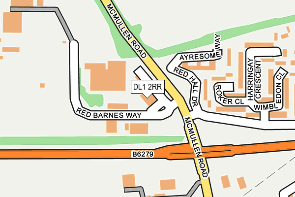
DL1 2RR lies on Red Barnes Way in Darlington. DL1 2RR is located in the Stephenson electoral ward, within the unitary authority of Darlington and the English Parliamentary constituency of Darlington. The Sub Integrated Care Board (ICB) Location is NHS North East and North Cumbria ICB - 16C and the police force is Durham. This postcode has been in use since January 1991.


GetTheData
Source: OS OpenMap – Local (Ordnance Survey)
Source: OS VectorMap District (Ordnance Survey)
Licence: Open Government Licence (requires attribution)
| Easting | 430867 |
| Northing | 515383 |
| Latitude | 54.532799 |
| Longitude | -1.524526 |
GetTheData
Source: Open Postcode Geo
Licence: Open Government Licence
| Street | Red Barnes Way |
| Town/City | Darlington |
| Country | England |
| Postcode District | DL1 |
➜ See where DL1 is on a map ➜ Where is Darlington? | |
GetTheData
Source: Land Registry Price Paid Data
Licence: Open Government Licence
Elevation or altitude of DL1 2RR as distance above sea level:
| Metres | Feet | |
|---|---|---|
| Elevation | 50m | 164ft |
Elevation is measured from the approximate centre of the postcode, to the nearest point on an OS contour line from OS Terrain 50, which has contour spacing of ten vertical metres.
➜ How high above sea level am I? Find the elevation of your current position using your device's GPS.
GetTheData
Source: Open Postcode Elevation
Licence: Open Government Licence
| Ward | Stephenson |
| Constituency | Darlington |
GetTheData
Source: ONS Postcode Database
Licence: Open Government Licence
| Red Hall Drive (Coombe Drive) | Red Hall | 137m |
| Red Hall Drive (Coombe Drive) | Red Hall | 139m |
| Kwik Fit (Mcmullen Road) | Lingfield | 335m |
| Kwik Fit (Mcmullen Road) | Lingfield | 362m |
| Mcmullen Road (Haughton Road) | Haughton Road | 369m |
| North Road Station | 1.9km |
| Darlington Station | 2km |
| Dinsdale Station | 4.2km |
GetTheData
Source: NaPTAN
Licence: Open Government Licence
GetTheData
Source: ONS Postcode Database
Licence: Open Government Licence


➜ Get more ratings from the Food Standards Agency
GetTheData
Source: Food Standards Agency
Licence: FSA terms & conditions
| Last Collection | |||
|---|---|---|---|
| Location | Mon-Fri | Sat | Distance |
| Coombe Drive | 17:00 | 11:15 | 346m |
| Royal Mail House | 638m | ||
| Haughton Le Skerne Post Office | 17:30 | 11:00 | 638m |
GetTheData
Source: Dracos
Licence: Creative Commons Attribution-ShareAlike
The below table lists the International Territorial Level (ITL) codes (formerly Nomenclature of Territorial Units for Statistics (NUTS) codes) and Local Administrative Units (LAU) codes for DL1 2RR:
| ITL 1 Code | Name |
|---|---|
| TLC | North East (England) |
| ITL 2 Code | Name |
| TLC1 | Tees Valley and Durham |
| ITL 3 Code | Name |
| TLC13 | Darlington |
| LAU 1 Code | Name |
| E06000005 | Darlington |
GetTheData
Source: ONS Postcode Directory
Licence: Open Government Licence
The below table lists the Census Output Area (OA), Lower Layer Super Output Area (LSOA), and Middle Layer Super Output Area (MSOA) for DL1 2RR:
| Code | Name | |
|---|---|---|
| OA | E00062165 | |
| LSOA | E01012327 | Darlington 009B |
| MSOA | E02002567 | Darlington 009 |
GetTheData
Source: ONS Postcode Directory
Licence: Open Government Licence
| DL1 2SL | Roker Close | 162m |
| DL1 2SP | Wimbledon Close | 255m |
| DL1 2SW | Harringay Crescent | 259m |
| DL1 2SR | Headingley Crescent | 307m |
| DL1 2TB | Mcmullen Road | 312m |
| DL1 2GA | Mcmullen Road | 326m |
| DL1 2SS | Trafford Close | 334m |
| DL1 2EA | Haughton Road | 338m |
| DL1 2DA | Haughton Road | 388m |
| DL1 1NQ | Gibb Avenue | 391m |
GetTheData
Source: Open Postcode Geo; Land Registry Price Paid Data
Licence: Open Government Licence