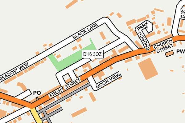
DH6 3QZ is located in the Trimdon and Thornley electoral ward, within the unitary authority of County Durham and the English Parliamentary constituency of Sedgefield. The Sub Integrated Care Board (ICB) Location is NHS North East and North Cumbria ICB - 84H and the police force is Durham. This postcode has been in use since April 1985.


GetTheData
Source: OS OpenMap – Local (Ordnance Survey)
Source: OS VectorMap District (Ordnance Survey)
Licence: Open Government Licence (requires attribution)
| Easting | 437787 |
| Northing | 539216 |
| Latitude | 54.746499 |
| Longitude | -1.414532 |
GetTheData
Source: Open Postcode Geo
Licence: Open Government Licence
| Country | England |
| Postcode District | DH6 |
➜ See where DH6 is on a map ➜ Where is Wheatley Hill? | |
GetTheData
Source: Land Registry Price Paid Data
Licence: Open Government Licence
Elevation or altitude of DH6 3QZ as distance above sea level:
| Metres | Feet | |
|---|---|---|
| Elevation | 150m | 492ft |
Elevation is measured from the approximate centre of the postcode, to the nearest point on an OS contour line from OS Terrain 50, which has contour spacing of ten vertical metres.
➜ How high above sea level am I? Find the elevation of your current position using your device's GPS.
GetTheData
Source: Open Postcode Elevation
Licence: Open Government Licence
| Ward | Trimdon And Thornley |
| Constituency | Sedgefield |
GetTheData
Source: ONS Postcode Database
Licence: Open Government Licence
| Royalty (B1279 Front Street) | Wheatley Hill | 134m |
| Royalty (B1279 Front Street) | Wheatley Hill | 136m |
| Vincents Corner - Front St (Front Street) | Wheatley Hill | 147m |
| Vincents Corner - Front St (Front Street) | Wheatley Hill | 167m |
| Vincents Corner - Cemetery Rd (Woodlands Avenue) | Wheatley Hill | 231m |
GetTheData
Source: NaPTAN
Licence: Open Government Licence
GetTheData
Source: ONS Postcode Database
Licence: Open Government Licence


➜ Get more ratings from the Food Standards Agency
GetTheData
Source: Food Standards Agency
Licence: FSA terms & conditions
| Last Collection | |||
|---|---|---|---|
| Location | Mon-Fri | Sat | Distance |
| Thornlaw, Stanley Tce | 17:15 | 11:45 | 1,816m |
| Newlands Road | 16:30 | 09:30 | 1,891m |
| Ludworth Post Office | 17:15 | 11:45 | 2,745m |
GetTheData
Source: Dracos
Licence: Creative Commons Attribution-ShareAlike
The below table lists the International Territorial Level (ITL) codes (formerly Nomenclature of Territorial Units for Statistics (NUTS) codes) and Local Administrative Units (LAU) codes for DH6 3QZ:
| ITL 1 Code | Name |
|---|---|
| TLC | North East (England) |
| ITL 2 Code | Name |
| TLC1 | Tees Valley and Durham |
| ITL 3 Code | Name |
| TLC14 | Durham |
| LAU 1 Code | Name |
| E06000047 | County Durham |
GetTheData
Source: ONS Postcode Directory
Licence: Open Government Licence
The below table lists the Census Output Area (OA), Lower Layer Super Output Area (LSOA), and Middle Layer Super Output Area (MSOA) for DH6 3QZ:
| Code | Name | |
|---|---|---|
| OA | E00105502 | |
| LSOA | E01020788 | County Durham 040A |
| MSOA | E02004331 | County Durham 040 |
GetTheData
Source: ONS Postcode Directory
Licence: Open Government Licence
| DH6 3JG | Back Granville Terrace | 51m |
| DH6 3NJ | Front Street | 53m |
| DH6 3NN | Dennis Street | 66m |
| DH6 3JL | Front Street | 68m |
| DH6 3NQ | Moor View | 85m |
| DH6 3NW | Percy Street | 89m |
| DH6 3JJ | Front Street | 94m |
| DH6 3JQ | Granville Terrace | 116m |
| DH6 3PJ | Black Lane | 138m |
| DH6 3JW | Alexandra Terrace | 139m |
GetTheData
Source: Open Postcode Geo; Land Registry Price Paid Data
Licence: Open Government Licence