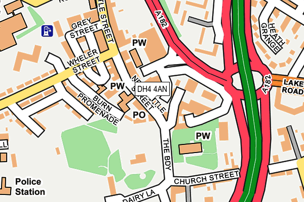
DH4 4AN lies on Newbottle Street in Houghton Le Spring. DH4 4AN is located in the Houghton electoral ward, within the metropolitan district of Sunderland and the English Parliamentary constituency of Houghton and Sunderland South. The Sub Integrated Care Board (ICB) Location is NHS North East and North Cumbria ICB - 00P and the police force is Northumbria. This postcode has been in use since January 1980.


GetTheData
Source: OS OpenMap – Local (Ordnance Survey)
Source: OS VectorMap District (Ordnance Survey)
Licence: Open Government Licence (requires attribution)
| Easting | 434108 |
| Northing | 549937 |
| Latitude | 54.843100 |
| Longitude | -1.470423 |
GetTheData
Source: Open Postcode Geo
Licence: Open Government Licence
| Street | Newbottle Street |
| Town/City | Houghton Le Spring |
| Country | England |
| Postcode District | DH4 |
➜ See where DH4 is on a map ➜ Where is Houghton-le-Spring? | |
GetTheData
Source: Land Registry Price Paid Data
Licence: Open Government Licence
Elevation or altitude of DH4 4AN as distance above sea level:
| Metres | Feet | |
|---|---|---|
| Elevation | 60m | 197ft |
Elevation is measured from the approximate centre of the postcode, to the nearest point on an OS contour line from OS Terrain 50, which has contour spacing of ten vertical metres.
➜ How high above sea level am I? Find the elevation of your current position using your device's GPS.
GetTheData
Source: Open Postcode Elevation
Licence: Open Government Licence
| Ward | Houghton |
| Constituency | Houghton And Sunderland South |
GetTheData
Source: ONS Postcode Database
Licence: Open Government Licence
WHITE LION HOTEL, NEWBOTTLE STREET, HOUGHTON LE SPRING, DH4 4AN 2004 31 MAR £410,000 |
WHITE LION HOTEL, NEWBOTTLE STREET, HOUGHTON LE SPRING, DH4 4AN 2004 31 MAR £410,000 |
➜ Houghton-le-Spring house prices
GetTheData
Source: HM Land Registry Price Paid Data
Licence: Contains HM Land Registry data © Crown copyright and database right 2025. This data is licensed under the Open Government Licence v3.0.
| Houghton-le-spring (Newbottle Street) | Houghton-le-spring | 19m |
| Houghton-le-spring (Newbottle Street) | Houghton-le-spring | 70m |
| Houghton-le-spring (Newbottle Street) | Houghton-le-spring | 71m |
| Houghton-le-spring (The Broadway) | Houghton-le-spring | 101m |
| Houghton Le Spring (The Broadway) | Houghton-le-spring | 105m |
GetTheData
Source: NaPTAN
Licence: Open Government Licence
GetTheData
Source: ONS Postcode Database
Licence: Open Government Licence


➜ Get more ratings from the Food Standards Agency
GetTheData
Source: Food Standards Agency
Licence: FSA terms & conditions
| Last Collection | |||
|---|---|---|---|
| Location | Mon-Fri | Sat | Distance |
| Dunelm Drive | 17:30 | 12:15 | 843m |
| Hetton Road Hetton Le Hole | 17:15 | 12:15 | 1,505m |
| Humbledon Park | 17:00 | 11:30 | 1,966m |
GetTheData
Source: Dracos
Licence: Creative Commons Attribution-ShareAlike
The below table lists the International Territorial Level (ITL) codes (formerly Nomenclature of Territorial Units for Statistics (NUTS) codes) and Local Administrative Units (LAU) codes for DH4 4AN:
| ITL 1 Code | Name |
|---|---|
| TLC | North East (England) |
| ITL 2 Code | Name |
| TLC2 | Northumberland, and Tyne and Wear |
| ITL 3 Code | Name |
| TLC23 | Sunderland |
| LAU 1 Code | Name |
| E08000024 | Sunderland |
GetTheData
Source: ONS Postcode Directory
Licence: Open Government Licence
The below table lists the Census Output Area (OA), Lower Layer Super Output Area (LSOA), and Middle Layer Super Output Area (MSOA) for DH4 4AN:
| Code | Name | |
|---|---|---|
| OA | E00044437 | |
| LSOA | E01008754 | Sunderland 034F |
| MSOA | E02001824 | Sunderland 034 |
GetTheData
Source: ONS Postcode Directory
Licence: Open Government Licence
| DH4 4AL | Newbottle Street | 23m |
| DH4 5AS | Vine Place | 36m |
| DH4 4BD | Sunderland Street | 44m |
| DH4 4DN | Church Street | 117m |
| DH4 4BH | Mautland Street | 134m |
| DH4 5AR | Scott Street | 144m |
| DH4 5AT | Stevenson Street | 157m |
| DH4 5AD | Wheler Street | 162m |
| DH4 4AF | Newbottle Street | 171m |
| DH4 5AU | Chaucer Street | 203m |
GetTheData
Source: Open Postcode Geo; Land Registry Price Paid Data
Licence: Open Government Licence