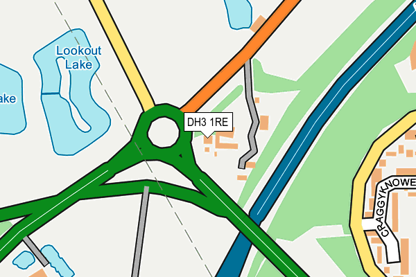
DH3 1RE is located in the Washington West electoral ward, within the metropolitan district of Sunderland and the English Parliamentary constituency of Washington and Sunderland West. The Sub Integrated Care Board (ICB) Location is NHS North East and North Cumbria ICB - 00P and the police force is Northumbria. This postcode has been in use since January 1980.


GetTheData
Source: OS OpenMap – Local (Ordnance Survey)
Source: OS VectorMap District (Ordnance Survey)
Licence: Open Government Licence (requires attribution)
| Easting | 428435 |
| Northing | 556985 |
| Latitude | 54.906786 |
| Longitude | -1.558064 |
GetTheData
Source: Open Postcode Geo
Licence: Open Government Licence
| Country | England |
| Postcode District | DH3 |
➜ See where DH3 is on a map | |
GetTheData
Source: Land Registry Price Paid Data
Licence: Open Government Licence
Elevation or altitude of DH3 1RE as distance above sea level:
| Metres | Feet | |
|---|---|---|
| Elevation | 120m | 394ft |
Elevation is measured from the approximate centre of the postcode, to the nearest point on an OS contour line from OS Terrain 50, which has contour spacing of ten vertical metres.
➜ How high above sea level am I? Find the elevation of your current position using your device's GPS.
GetTheData
Source: Open Postcode Elevation
Licence: Open Government Licence
| Ward | Washington West |
| Constituency | Washington And Sunderland West |
GetTheData
Source: ONS Postcode Database
Licence: Open Government Licence
| Foxpond Roundabout (Eighton Road) | Springwell | 134m |
| Foxpond Roundabout (Eighton Road) | Springwell | 137m |
| Mill House Inn (B1288) | Springwell | 178m |
| Mill House Inn (B1288) | Springwell | 223m |
| Portobello Road-lazy Bar Ranch (Portobello Road) | Birtley | 533m |
| Heworth Station | 5km |
GetTheData
Source: NaPTAN
Licence: Open Government Licence
GetTheData
Source: ONS Postcode Database
Licence: Open Government Licence


➜ Get more ratings from the Food Standards Agency
GetTheData
Source: Food Standards Agency
Licence: FSA terms & conditions
| Last Collection | |||
|---|---|---|---|
| Location | Mon-Fri | Sat | Distance |
| Craggyknowe | 16:45 | 12:30 | 289m |
| Cragside Road | 16:30 | 10:30 | 626m |
| Armstrong Road | 626m | ||
GetTheData
Source: Dracos
Licence: Creative Commons Attribution-ShareAlike
The below table lists the International Territorial Level (ITL) codes (formerly Nomenclature of Territorial Units for Statistics (NUTS) codes) and Local Administrative Units (LAU) codes for DH3 1RE:
| ITL 1 Code | Name |
|---|---|
| TLC | North East (England) |
| ITL 2 Code | Name |
| TLC2 | Northumberland, and Tyne and Wear |
| ITL 3 Code | Name |
| TLC23 | Sunderland |
| LAU 1 Code | Name |
| E08000024 | Sunderland |
GetTheData
Source: ONS Postcode Directory
Licence: Open Government Licence
The below table lists the Census Output Area (OA), Lower Layer Super Output Area (LSOA), and Middle Layer Super Output Area (MSOA) for DH3 1RE:
| Code | Name | |
|---|---|---|
| OA | E00045048 | |
| LSOA | E01008873 | Sunderland 010A |
| MSOA | E02001800 | Sunderland 010 |
GetTheData
Source: ONS Postcode Directory
Licence: Open Government Licence
| NE37 1JY | Craggyknowe | 298m |
| NE37 1JZ | Craggyknowe | 300m |
| NE37 1LA | Herdinghill | 345m |
| NE37 1PP | Whitworth Road | 389m |
| NE37 1JX | Heatherlaw | 404m |
| NE37 1LD | Westernmoor | 424m |
| NE38 0AD | Phoenix Road | 434m |
| NE37 1LP | Westernmoor | 445m |
| NE37 1LR | Westernmoor | 501m |
| NE37 1LT | Westernmoor | 502m |
GetTheData
Source: Open Postcode Geo; Land Registry Price Paid Data
Licence: Open Government Licence