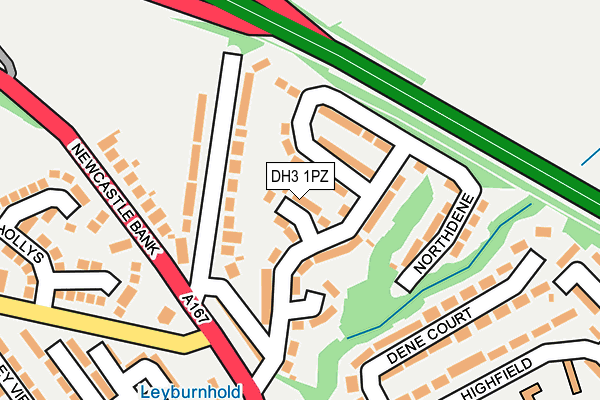
DH3 1PZ lies on North Dene in Birtley, Chester Le Street. DH3 1PZ is located in the Lamesley electoral ward, within the metropolitan district of Gateshead and the English Parliamentary constituency of Blaydon. The Sub Integrated Care Board (ICB) Location is NHS North East and North Cumbria ICB - 13T and the police force is Northumbria. This postcode has been in use since January 1980.


GetTheData
Source: OS OpenMap – Local (Ordnance Survey)
Source: OS VectorMap District (Ordnance Survey)
Licence: Open Government Licence (requires attribution)
| Easting | 427150 |
| Northing | 557145 |
| Latitude | 54.908287 |
| Longitude | -1.578078 |
GetTheData
Source: Open Postcode Geo
Licence: Open Government Licence
| Street | North Dene |
| Locality | Birtley |
| Town/City | Chester Le Street |
| Country | England |
| Postcode District | DH3 |
➜ See where DH3 is on a map ➜ Where is Birtley? | |
GetTheData
Source: Land Registry Price Paid Data
Licence: Open Government Licence
Elevation or altitude of DH3 1PZ as distance above sea level:
| Metres | Feet | |
|---|---|---|
| Elevation | 70m | 230ft |
Elevation is measured from the approximate centre of the postcode, to the nearest point on an OS contour line from OS Terrain 50, which has contour spacing of ten vertical metres.
➜ How high above sea level am I? Find the elevation of your current position using your device's GPS.
GetTheData
Source: Open Postcode Elevation
Licence: Open Government Licence
| Ward | Lamesley |
| Constituency | Blaydon |
GetTheData
Source: ONS Postcode Database
Licence: Open Government Licence
| Newcastle Bank-long Bank (Newcastle Bank) | Birtley | 153m |
| Durham Road-northdene (Durham Road) | Birtley | 180m |
| The Hollys (Lamesley Road) | Birtley | 297m |
| Birtley East Primary School (Malone Gardens) | Birtley | 323m |
| The Hollys (Lamesley Road) | Birtley | 325m |
| Heworth Station | 5km |
| Dunston Station | 6.2km |
GetTheData
Source: NaPTAN
Licence: Open Government Licence
| Percentage of properties with Next Generation Access | 100.0% |
| Percentage of properties with Superfast Broadband | 100.0% |
| Percentage of properties with Ultrafast Broadband | 100.0% |
| Percentage of properties with Full Fibre Broadband | 100.0% |
Superfast Broadband is between 30Mbps and 300Mbps
Ultrafast Broadband is > 300Mbps
| Median download speed | 39.1Mbps |
| Average download speed | 52.7Mbps |
| Maximum download speed | 350.00Mbps |
| Median upload speed | 9.8Mbps |
| Average upload speed | 10.4Mbps |
| Maximum upload speed | 20.00Mbps |
| Percentage of properties unable to receive 2Mbps | 0.0% |
| Percentage of properties unable to receive 5Mbps | 0.0% |
| Percentage of properties unable to receive 10Mbps | 0.0% |
| Percentage of properties unable to receive 30Mbps | 0.0% |
GetTheData
Source: Ofcom
Licence: Ofcom Terms of Use (requires attribution)
Estimated total energy consumption in DH3 1PZ by fuel type, 2015.
| Consumption (kWh) | 449,388 |
|---|---|
| Meter count | 34 |
| Mean (kWh/meter) | 13,217 |
| Median (kWh/meter) | 12,677 |
| Consumption (kWh) | 123,482 |
|---|---|
| Meter count | 34 |
| Mean (kWh/meter) | 3,632 |
| Median (kWh/meter) | 3,341 |
GetTheData
Source: Postcode level gas estimates: 2015 (experimental)
Source: Postcode level electricity estimates: 2015 (experimental)
Licence: Open Government Licence
GetTheData
Source: ONS Postcode Database
Licence: Open Government Licence


➜ Get more ratings from the Food Standards Agency
GetTheData
Source: Food Standards Agency
Licence: FSA terms & conditions
| Last Collection | |||
|---|---|---|---|
| Location | Mon-Fri | Sat | Distance |
| Windsor Road | 17:15 | 11:45 | 429m |
| Selkirk Crescent | 17:15 | 11:45 | 530m |
| The Mount | 16:00 | 10:30 | 1,204m |
GetTheData
Source: Dracos
Licence: Creative Commons Attribution-ShareAlike
The below table lists the International Territorial Level (ITL) codes (formerly Nomenclature of Territorial Units for Statistics (NUTS) codes) and Local Administrative Units (LAU) codes for DH3 1PZ:
| ITL 1 Code | Name |
|---|---|
| TLC | North East (England) |
| ITL 2 Code | Name |
| TLC2 | Northumberland, and Tyne and Wear |
| ITL 3 Code | Name |
| TLC22 | Tyneside |
| LAU 1 Code | Name |
| E08000037 | Gateshead |
GetTheData
Source: ONS Postcode Directory
Licence: Open Government Licence
The below table lists the Census Output Area (OA), Lower Layer Super Output Area (LSOA), and Middle Layer Super Output Area (MSOA) for DH3 1PZ:
| Code | Name | |
|---|---|---|
| OA | E00041709 | |
| LSOA | E01008224 | Gateshead 025C |
| MSOA | E02001706 | Gateshead 025 |
GetTheData
Source: ONS Postcode Directory
Licence: Open Government Licence
| DH3 1PX | Long Bank | 77m |
| DH3 1QA | North Dene | 88m |
| DH3 1QB | North Dene | 90m |
| DH3 1PU | Long Bank | 111m |
| DH3 1QD | North Dene | 139m |
| DH3 1PT | Newcastle Bank | 160m |
| DH3 1QH | Dene Court | 175m |
| DH3 1QG | Highfield | 241m |
| DH3 1QQ | Highfield | 242m |
| DH3 1QF | Leybourne Hold | 257m |
GetTheData
Source: Open Postcode Geo; Land Registry Price Paid Data
Licence: Open Government Licence