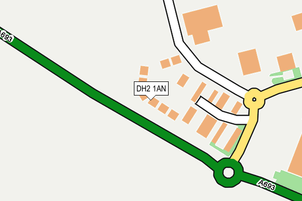
DH2 1AN lies on Lumley Court in Drum Industrial Estate, Chester Le Street. DH2 1AN is located in the North Lodge electoral ward, within the unitary authority of County Durham and the English Parliamentary constituency of North Durham. The Sub Integrated Care Board (ICB) Location is NHS North East and North Cumbria ICB - 84H and the police force is Durham. This postcode has been in use since February 2008.


GetTheData
Source: OS OpenMap – Local (Ordnance Survey)
Source: OS VectorMap District (Ordnance Survey)
Licence: Open Government Licence (requires attribution)
| Easting | 426336 |
| Northing | 553022 |
| Latitude | 54.871281 |
| Longitude | -1.591149 |
GetTheData
Source: Open Postcode Geo
Licence: Open Government Licence
| Street | Lumley Court |
| Locality | Drum Industrial Estate |
| Town/City | Chester Le Street |
| Country | England |
| Postcode District | DH2 |
➜ See where DH2 is on a map ➜ Where is Chester-le-Street? | |
GetTheData
Source: Land Registry Price Paid Data
Licence: Open Government Licence
Elevation or altitude of DH2 1AN as distance above sea level:
| Metres | Feet | |
|---|---|---|
| Elevation | 60m | 197ft |
Elevation is measured from the approximate centre of the postcode, to the nearest point on an OS contour line from OS Terrain 50, which has contour spacing of ten vertical metres.
➜ How high above sea level am I? Find the elevation of your current position using your device's GPS.
GetTheData
Source: Open Postcode Elevation
Licence: Open Government Licence
| Ward | North Lodge |
| Constituency | North Durham |
GetTheData
Source: ONS Postcode Database
Licence: Open Government Licence
| Backleys (Drum Road) | Drum Industrial Estate | 197m |
| Backleys (Drum Road) | Drum Industrial Estate | 212m |
| Plough Inn (Pelton Lane) | Pelton | 432m |
| Plough Inn (Pelton Lane) | Pelton | 440m |
| Mysons (Drum Road) | Drum Industrial Estate | 618m |
| Chester-le-Street Station | 2km |
GetTheData
Source: NaPTAN
Licence: Open Government Licence
| Median download speed | 56.3Mbps |
| Average download speed | 42.7Mbps |
| Maximum download speed | 78.03Mbps |
| Median upload speed | 16.0Mbps |
| Average upload speed | 11.5Mbps |
| Maximum upload speed | 20.00Mbps |
GetTheData
Source: Ofcom
Licence: Ofcom Terms of Use (requires attribution)
GetTheData
Source: ONS Postcode Database
Licence: Open Government Licence


➜ Get more ratings from the Food Standards Agency
GetTheData
Source: Food Standards Agency
Licence: FSA terms & conditions
| Last Collection | |||
|---|---|---|---|
| Location | Mon-Fri | Sat | Distance |
| Conyers Road | 17:00 | 11:45 | 850m |
| Drum Road Ind Estate | 18:30 | 11:15 | 862m |
| Pelton Post Office | 17:15 | 11:45 | 973m |
GetTheData
Source: Dracos
Licence: Creative Commons Attribution-ShareAlike
The below table lists the International Territorial Level (ITL) codes (formerly Nomenclature of Territorial Units for Statistics (NUTS) codes) and Local Administrative Units (LAU) codes for DH2 1AN:
| ITL 1 Code | Name |
|---|---|
| TLC | North East (England) |
| ITL 2 Code | Name |
| TLC1 | Tees Valley and Durham |
| ITL 3 Code | Name |
| TLC14 | Durham |
| LAU 1 Code | Name |
| E06000047 | County Durham |
GetTheData
Source: ONS Postcode Directory
Licence: Open Government Licence
The below table lists the Census Output Area (OA), Lower Layer Super Output Area (LSOA), and Middle Layer Super Output Area (MSOA) for DH2 1AN:
| Code | Name | |
|---|---|---|
| OA | E00104570 | |
| LSOA | E01020612 | County Durham 007E |
| MSOA | E02004292 | County Durham 007 |
GetTheData
Source: ONS Postcode Directory
Licence: Open Government Licence
| DH2 1ST | 343m | |
| DH2 1AQ | Angel Park | 442m |
| DH2 1HZ | Pelton Lane | 519m |
| DH2 1AG | 523m | |
| DH2 1JD | Arundel Walk | 571m |
| DH2 1JB | Courtney Drive | 586m |
| DH2 1JA | Gairloch Drive | 660m |
| DH2 1HX | Brecon Place | 662m |
| DH2 2HR | Beechwoods | 725m |
| DH2 2HT | Cedars | 737m |
GetTheData
Source: Open Postcode Geo; Land Registry Price Paid Data
Licence: Open Government Licence