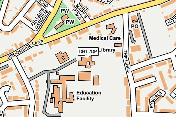
DH1 2QP is located in the Belmont electoral ward, within the unitary authority of County Durham and the English Parliamentary constituency of City of Durham. The Sub Integrated Care Board (ICB) Location is NHS North East and North Cumbria ICB - 84H and the police force is Durham. This postcode has been in use since January 1980.


GetTheData
Source: OS OpenMap – Local (Ordnance Survey)
Source: OS VectorMap District (Ordnance Survey)
Licence: Open Government Licence (requires attribution)
| Easting | 430490 |
| Northing | 543494 |
| Latitude | 54.785426 |
| Longitude | -1.527422 |
GetTheData
Source: Open Postcode Geo
Licence: Open Government Licence
| Country | England |
| Postcode District | DH1 |
➜ See where DH1 is on a map ➜ Where is Durham? | |
GetTheData
Source: Land Registry Price Paid Data
Licence: Open Government Licence
Elevation or altitude of DH1 2QP as distance above sea level:
| Metres | Feet | |
|---|---|---|
| Elevation | 90m | 295ft |
Elevation is measured from the approximate centre of the postcode, to the nearest point on an OS contour line from OS Terrain 50, which has contour spacing of ten vertical metres.
➜ How high above sea level am I? Find the elevation of your current position using your device's GPS.
GetTheData
Source: Open Postcode Elevation
Licence: Open Government Licence
| Ward | Belmont |
| Constituency | City Of Durham |
GetTheData
Source: ONS Postcode Database
Licence: Open Government Licence
| Vicarage (Church View) | Belmont | 145m |
| The Links - Shops (The Links) | Belmont | 145m |
| The Links - Shops (The Links) | Belmont | 165m |
| Vicarage (Church View) | Belmont | 174m |
| Buckinghamshire Road - Schools End (Buckinghamshire Road (Schools End)) | Belmont | 219m |
| Durham Station | 3.6km |
GetTheData
Source: NaPTAN
Licence: Open Government Licence
GetTheData
Source: ONS Postcode Database
Licence: Open Government Licence


➜ Get more ratings from the Food Standards Agency
GetTheData
Source: Food Standards Agency
Licence: FSA terms & conditions
| Last Collection | |||
|---|---|---|---|
| Location | Mon-Fri | Sat | Distance |
| Moor End | 17:15 | 12:00 | 167m |
| Belmont Post Office | 17:30 | 12:00 | 195m |
| Devonshire Road | 17:15 | 12:00 | 432m |
GetTheData
Source: Dracos
Licence: Creative Commons Attribution-ShareAlike
The below table lists the International Territorial Level (ITL) codes (formerly Nomenclature of Territorial Units for Statistics (NUTS) codes) and Local Administrative Units (LAU) codes for DH1 2QP:
| ITL 1 Code | Name |
|---|---|
| TLC | North East (England) |
| ITL 2 Code | Name |
| TLC1 | Tees Valley and Durham |
| ITL 3 Code | Name |
| TLC14 | Durham |
| LAU 1 Code | Name |
| E06000047 | County Durham |
GetTheData
Source: ONS Postcode Directory
Licence: Open Government Licence
The below table lists the Census Output Area (OA), Lower Layer Super Output Area (LSOA), and Middle Layer Super Output Area (MSOA) for DH1 2QP:
| Code | Name | |
|---|---|---|
| OA | E00104950 | |
| LSOA | E01020683 | County Durham 028B |
| MSOA | E02004312 | County Durham 028 |
GetTheData
Source: ONS Postcode Directory
Licence: Open Government Licence
| DH1 2QW | Broomside Lane | 93m |
| DH1 2UW | The Links | 105m |
| DH1 2QD | Angerstein Court | 125m |
| DH1 2QS | Church View | 171m |
| DH1 2BU | Bishops Close | 176m |
| DH1 1NP | St Marys Road | 187m |
| DH1 2AA | Cheveley Park Shopping Centre | 189m |
| DH1 2AF | Grassdale | 196m |
| DH1 2AG | The Links | 214m |
| DH1 1AB | Fellside Gardens | 221m |
GetTheData
Source: Open Postcode Geo; Land Registry Price Paid Data
Licence: Open Government Licence