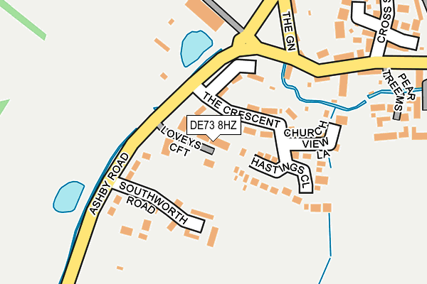
DE73 8HZ lies on Loveys Croft in Breedon On The Hill, Derby. DE73 8HZ is located in the Worthington & Breedon electoral ward, within the local authority district of North West Leicestershire and the English Parliamentary constituency of North West Leicestershire. The Sub Integrated Care Board (ICB) Location is NHS Leicester, Leicestershire and Rutland ICB - 04V and the police force is Leicestershire. This postcode has been in use since September 2004.


GetTheData
Source: OS OpenMap – Local (Ordnance Survey)
Source: OS VectorMap District (Ordnance Survey)
Licence: Open Government Licence (requires attribution)
| Easting | 440285 |
| Northing | 322743 |
| Latitude | 52.800748 |
| Longitude | -1.403923 |
GetTheData
Source: Open Postcode Geo
Licence: Open Government Licence
| Street | Loveys Croft |
| Locality | Breedon On The Hill |
| Town/City | Derby |
| Country | England |
| Postcode District | DE73 |
➜ See where DE73 is on a map ➜ Where is Breedon on the Hill? | |
GetTheData
Source: Land Registry Price Paid Data
Licence: Open Government Licence
Elevation or altitude of DE73 8HZ as distance above sea level:
| Metres | Feet | |
|---|---|---|
| Elevation | 80m | 262ft |
Elevation is measured from the approximate centre of the postcode, to the nearest point on an OS contour line from OS Terrain 50, which has contour spacing of ten vertical metres.
➜ How high above sea level am I? Find the elevation of your current position using your device's GPS.
GetTheData
Source: Open Postcode Elevation
Licence: Open Government Licence
| Ward | Worthington & Breedon |
| Constituency | North West Leicestershire |
GetTheData
Source: ONS Postcode Database
Licence: Open Government Licence
| The Crescent (Ashby Road) | Breedon-on-the-hill | 76m |
| The Green | Breedon-on-the-hill | 151m |
| Cross Street (Main Street) | Breedon-on-the-hill | 239m |
| Cross Street (Main Street) | Breedon-on-the-hill | 311m |
| Tonge Lane (Main Street) | Breedon-on-the-hill | 793m |
GetTheData
Source: NaPTAN
Licence: Open Government Licence
| Percentage of properties with Next Generation Access | 100.0% |
| Percentage of properties with Superfast Broadband | 0.0% |
| Percentage of properties with Ultrafast Broadband | 0.0% |
| Percentage of properties with Full Fibre Broadband | 0.0% |
Superfast Broadband is between 30Mbps and 300Mbps
Ultrafast Broadband is > 300Mbps
| Percentage of properties unable to receive 2Mbps | 0.0% |
| Percentage of properties unable to receive 5Mbps | 0.0% |
| Percentage of properties unable to receive 10Mbps | 0.0% |
| Percentage of properties unable to receive 30Mbps | 100.0% |
GetTheData
Source: Ofcom
Licence: Ofcom Terms of Use (requires attribution)
GetTheData
Source: ONS Postcode Database
Licence: Open Government Licence


➜ Get more ratings from the Food Standards Agency
GetTheData
Source: Food Standards Agency
Licence: FSA terms & conditions
| Last Collection | |||
|---|---|---|---|
| Location | Mon-Fri | Sat | Distance |
| The Green | 16:30 | 10:30 | 203m |
| Breedon On The Hill P O | 16:30 | 10:30 | 561m |
| Berry Avenue | 16:30 | 10:30 | 1,061m |
GetTheData
Source: Dracos
Licence: Creative Commons Attribution-ShareAlike
The below table lists the International Territorial Level (ITL) codes (formerly Nomenclature of Territorial Units for Statistics (NUTS) codes) and Local Administrative Units (LAU) codes for DE73 8HZ:
| ITL 1 Code | Name |
|---|---|
| TLF | East Midlands (England) |
| ITL 2 Code | Name |
| TLF2 | Leicestershire, Rutland and Northamptonshire |
| ITL 3 Code | Name |
| TLF22 | Leicestershire CC and Rutland |
| LAU 1 Code | Name |
| E07000134 | North West Leicestershire |
GetTheData
Source: ONS Postcode Directory
Licence: Open Government Licence
The below table lists the Census Output Area (OA), Lower Layer Super Output Area (LSOA), and Middle Layer Super Output Area (MSOA) for DE73 8HZ:
| Code | Name | |
|---|---|---|
| OA | E00131555 | |
| LSOA | E01025924 | North West Leicestershire 001A |
| MSOA | E02005397 | North West Leicestershire 001 |
GetTheData
Source: ONS Postcode Directory
Licence: Open Government Licence
| DE73 8AY | The Crescent | 69m |
| DE73 8BN | Hastings Close | 119m |
| DE73 8AZ | Ashby Road | 156m |
| DE73 8AS | The Green | 225m |
| DE73 8JX | Pear Tree Mews | 256m |
| DE73 8BP | Stud Farm Close | 260m |
| DE73 8AX | Cross Street | 276m |
| DE73 8BY | Rectory Close | 277m |
| DE73 8ND | The Lime Kilns | 291m |
| DE73 8AU | Hollow Road | 314m |
GetTheData
Source: Open Postcode Geo; Land Registry Price Paid Data
Licence: Open Government Licence