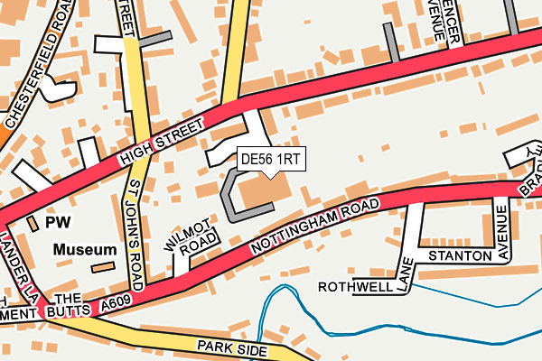
DE56 1RT lies on Springwood Gardens in Belper. DE56 1RT is located in the Belper East electoral ward, within the local authority district of Amber Valley and the English Parliamentary constituency of Mid Derbyshire. The Sub Integrated Care Board (ICB) Location is NHS Derby and Derbyshire ICB - 15M and the police force is Derbyshire. This postcode has been in use since March 2009.


GetTheData
Source: OS OpenMap – Local (Ordnance Survey)
Source: OS VectorMap District (Ordnance Survey)
Licence: Open Government Licence (requires attribution)
| Easting | 435432 |
| Northing | 347628 |
| Latitude | 53.024795 |
| Longitude | -1.473193 |
GetTheData
Source: Open Postcode Geo
Licence: Open Government Licence
| Street | Springwood Gardens |
| Town/City | Belper |
| Country | England |
| Postcode District | DE56 |
➜ See where DE56 is on a map ➜ Where is Belper? | |
GetTheData
Source: Land Registry Price Paid Data
Licence: Open Government Licence
Elevation or altitude of DE56 1RT as distance above sea level:
| Metres | Feet | |
|---|---|---|
| Elevation | 110m | 361ft |
Elevation is measured from the approximate centre of the postcode, to the nearest point on an OS contour line from OS Terrain 50, which has contour spacing of ten vertical metres.
➜ How high above sea level am I? Find the elevation of your current position using your device's GPS.
GetTheData
Source: Open Postcode Elevation
Licence: Open Government Licence
| Ward | Belper East |
| Constituency | Mid Derbyshire |
GetTheData
Source: ONS Postcode Database
Licence: Open Government Licence
| Springwood Gardens (Spencer Road) | Belper | 93m |
| The Grapes (High Street) | Belper | 131m |
| Rothwell Lane (Nottingham Road) | Belper | 148m |
| Coppice Brook (Park Side) | Belper | 187m |
| St Johns Road (Nottingham Road) | Belper | 191m |
| Belper Station | 0.6km |
| Ambergate Station | 4km |
| Duffield Station | 4.1km |
GetTheData
Source: NaPTAN
Licence: Open Government Licence
| Percentage of properties with Next Generation Access | 100.0% |
| Percentage of properties with Superfast Broadband | 100.0% |
| Percentage of properties with Ultrafast Broadband | 0.0% |
| Percentage of properties with Full Fibre Broadband | 0.0% |
Superfast Broadband is between 30Mbps and 300Mbps
Ultrafast Broadband is > 300Mbps
| Percentage of properties unable to receive 2Mbps | 0.0% |
| Percentage of properties unable to receive 5Mbps | 0.0% |
| Percentage of properties unable to receive 10Mbps | 0.0% |
| Percentage of properties unable to receive 30Mbps | 0.0% |
GetTheData
Source: Ofcom
Licence: Ofcom Terms of Use (requires attribution)
GetTheData
Source: ONS Postcode Database
Licence: Open Government Licence


➜ Get more ratings from the Food Standards Agency
GetTheData
Source: Food Standards Agency
Licence: FSA terms & conditions
| Last Collection | |||
|---|---|---|---|
| Location | Mon-Fri | Sat | Distance |
| Windmill Lane | 17:30 | 08:45 | 103m |
| Mill Lane | 17:30 | 07:15 | 187m |
| The Butts | 17:30 | 09:15 | 195m |
GetTheData
Source: Dracos
Licence: Creative Commons Attribution-ShareAlike
The below table lists the International Territorial Level (ITL) codes (formerly Nomenclature of Territorial Units for Statistics (NUTS) codes) and Local Administrative Units (LAU) codes for DE56 1RT:
| ITL 1 Code | Name |
|---|---|
| TLF | East Midlands (England) |
| ITL 2 Code | Name |
| TLF1 | Derbyshire and Nottinghamshire |
| ITL 3 Code | Name |
| TLF13 | South and West Derbyshire |
| LAU 1 Code | Name |
| E07000032 | Amber Valley |
GetTheData
Source: ONS Postcode Directory
Licence: Open Government Licence
The below table lists the Census Output Area (OA), Lower Layer Super Output Area (LSOA), and Middle Layer Super Output Area (MSOA) for DE56 1RT:
| Code | Name | |
|---|---|---|
| OA | E00098162 | |
| LSOA | E01019408 | Amber Valley 009A |
| MSOA | E02004037 | Amber Valley 009 |
GetTheData
Source: ONS Postcode Directory
Licence: Open Government Licence
| DE56 1JN | Nottingham Road | 41m |
| DE56 1JR | Springwood Gardens | 43m |
| DE56 1JA | Stoney Steps | 92m |
| DE56 1JF | Wilmot Road | 93m |
| DE56 1JG | Nottingham Road | 100m |
| DE56 1HZ | Dam Side | 104m |
| DE56 1JD | Rothwell Lane | 148m |
| DE56 1JE | St Johns Road | 149m |
| DE56 1JH | Nottingham Road | 163m |
| DE56 1JY | Spencer Road | 172m |
GetTheData
Source: Open Postcode Geo; Land Registry Price Paid Data
Licence: Open Government Licence