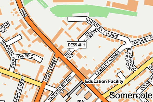
DE55 4HH lies on Mill Street in Somercotes, Alfreton. DE55 4HH is located in the Somercotes electoral ward, within the local authority district of Amber Valley and the English Parliamentary constituency of Amber Valley. The Sub Integrated Care Board (ICB) Location is NHS Derby and Derbyshire ICB - 15M and the police force is Derbyshire. This postcode has been in use since March 2003.


GetTheData
Source: OS OpenMap – Local (Ordnance Survey)
Source: OS VectorMap District (Ordnance Survey)
Licence: Open Government Licence (requires attribution)
| Easting | 442329 |
| Northing | 353977 |
| Latitude | 53.081364 |
| Longitude | -1.369539 |
GetTheData
Source: Open Postcode Geo
Licence: Open Government Licence
| Street | Mill Street |
| Locality | Somercotes |
| Town/City | Alfreton |
| Country | England |
| Postcode District | DE55 |
➜ See where DE55 is on a map ➜ Where is Somercotes? | |
GetTheData
Source: Land Registry Price Paid Data
Licence: Open Government Licence
Elevation or altitude of DE55 4HH as distance above sea level:
| Metres | Feet | |
|---|---|---|
| Elevation | 150m | 492ft |
Elevation is measured from the approximate centre of the postcode, to the nearest point on an OS contour line from OS Terrain 50, which has contour spacing of ten vertical metres.
➜ How high above sea level am I? Find the elevation of your current position using your device's GPS.
GetTheData
Source: Open Postcode Elevation
Licence: Open Government Licence
| Ward | Somercotes |
| Constituency | Amber Valley |
GetTheData
Source: ONS Postcode Database
Licence: Open Government Licence
| High Street (Nottingham Road) | Somercotes | 49m |
| High Street | Somercotes | 93m |
| High Street (Nottingham Road) | Somercotes | 139m |
| John Street (Sleetmoor Lane) | Somercotes | 205m |
| Market Place (Somercotes Hill) | Somercotes | 222m |
| Alfreton Station | 2.1km |
GetTheData
Source: NaPTAN
Licence: Open Government Licence
| Percentage of properties with Next Generation Access | 100.0% |
| Percentage of properties with Superfast Broadband | 100.0% |
| Percentage of properties with Ultrafast Broadband | 0.0% |
| Percentage of properties with Full Fibre Broadband | 0.0% |
Superfast Broadband is between 30Mbps and 300Mbps
Ultrafast Broadband is > 300Mbps
| Percentage of properties unable to receive 2Mbps | 0.0% |
| Percentage of properties unable to receive 5Mbps | 0.0% |
| Percentage of properties unable to receive 10Mbps | 0.0% |
| Percentage of properties unable to receive 30Mbps | 0.0% |
GetTheData
Source: Ofcom
Licence: Ofcom Terms of Use (requires attribution)
GetTheData
Source: ONS Postcode Database
Licence: Open Government Licence


➜ Get more ratings from the Food Standards Agency
GetTheData
Source: Food Standards Agency
Licence: FSA terms & conditions
| Last Collection | |||
|---|---|---|---|
| Location | Mon-Fri | Sat | Distance |
| Somercotes Post Office | 17:30 | 09:30 | 261m |
| Sleetmoor Lane | 17:30 | 09:30 | 345m |
| Alfreton Delivery Office Box | 17:30 | 12:00 | 445m |
GetTheData
Source: Dracos
Licence: Creative Commons Attribution-ShareAlike
The below table lists the International Territorial Level (ITL) codes (formerly Nomenclature of Territorial Units for Statistics (NUTS) codes) and Local Administrative Units (LAU) codes for DE55 4HH:
| ITL 1 Code | Name |
|---|---|
| TLF | East Midlands (England) |
| ITL 2 Code | Name |
| TLF1 | Derbyshire and Nottinghamshire |
| ITL 3 Code | Name |
| TLF13 | South and West Derbyshire |
| LAU 1 Code | Name |
| E07000032 | Amber Valley |
GetTheData
Source: ONS Postcode Directory
Licence: Open Government Licence
The below table lists the Census Output Area (OA), Lower Layer Super Output Area (LSOA), and Middle Layer Super Output Area (MSOA) for DE55 4HH:
| Code | Name | |
|---|---|---|
| OA | E00098466 | |
| LSOA | E01019471 | Amber Valley 003E |
| MSOA | E02004031 | Amber Valley 003 |
GetTheData
Source: ONS Postcode Directory
Licence: Open Government Licence
| DE55 4JF | Mill Street | 49m |
| DE55 4JG | Nottingham Road | 74m |
| DE55 4TB | Pennytown Court | 84m |
| DE55 4LY | Nottingham Road | 86m |
| DE55 4HD | High Street | 132m |
| DE55 4LT | Langley Avenue | 146m |
| DE55 1SB | Tower Close | 169m |
| DE55 4LU | Wheatley Avenue | 173m |
| DE55 4JH | Nottingham Road | 174m |
| DE55 4NA | Bonsall Drive | 176m |
GetTheData
Source: Open Postcode Geo; Land Registry Price Paid Data
Licence: Open Government Licence