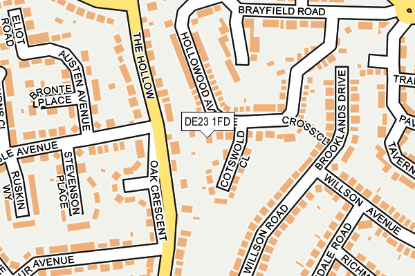
DE23 1FD lies on Cross Close Walk in Littleover, Derby. DE23 1FD is located in the Littleover electoral ward, within the unitary authority of Derby and the English Parliamentary constituency of Derby North. The Sub Integrated Care Board (ICB) Location is NHS Derby and Derbyshire ICB - 15M and the police force is Derbyshire. This postcode has been in use since June 2002.


GetTheData
Source: OS OpenMap – Local (Ordnance Survey)
Source: OS VectorMap District (Ordnance Survey)
Licence: Open Government Licence (requires attribution)
| Easting | 433124 |
| Northing | 333731 |
| Latitude | 52.900005 |
| Longitude | -1.509020 |
GetTheData
Source: Open Postcode Geo
Licence: Open Government Licence
| Street | Cross Close Walk |
| Locality | Littleover |
| Town/City | Derby |
| Country | England |
| Postcode District | DE23 |
➜ See where DE23 is on a map ➜ Where is Derby? | |
GetTheData
Source: Land Registry Price Paid Data
Licence: Open Government Licence
Elevation or altitude of DE23 1FD as distance above sea level:
| Metres | Feet | |
|---|---|---|
| Elevation | 80m | 262ft |
Elevation is measured from the approximate centre of the postcode, to the nearest point on an OS contour line from OS Terrain 50, which has contour spacing of ten vertical metres.
➜ How high above sea level am I? Find the elevation of your current position using your device's GPS.
GetTheData
Source: Open Postcode Elevation
Licence: Open Government Licence
| Ward | Littleover |
| Constituency | Derby North |
GetTheData
Source: ONS Postcode Database
Licence: Open Government Licence
HAWTHORNS, CROSS CLOSE WALK, LITTLEOVER, DERBY, DE23 1FD 2018 15 AUG £210,000 |
2016 3 JUN £275,000 |
CHRYSMAIRN, CROSS CLOSE WALK, LITTLEOVER, DERBY, DE23 1FD 2014 10 DEC £250,000 |
2004 1 JUN £220,000 |
GetTheData
Source: HM Land Registry Price Paid Data
Licence: Contains HM Land Registry data © Crown copyright and database right 2025. This data is licensed under the Open Government Licence v3.0.
| The Hollow | Littleover | 151m |
| Harpur Avenue (Blagreaves Lane) | Littleover | 184m |
| The Hollow | Littleover | 199m |
| Harpur Avenue (Blagreaves Lane) | Littleover | 214m |
| Normanton Lane | Littleover | 350m |
| Peartree Station | 2.4km |
| Derby Station | 3.6km |
GetTheData
Source: NaPTAN
Licence: Open Government Licence
| Percentage of properties with Next Generation Access | 100.0% |
| Percentage of properties with Superfast Broadband | 100.0% |
| Percentage of properties with Ultrafast Broadband | 66.7% |
| Percentage of properties with Full Fibre Broadband | 0.0% |
Superfast Broadband is between 30Mbps and 300Mbps
Ultrafast Broadband is > 300Mbps
| Percentage of properties unable to receive 2Mbps | 0.0% |
| Percentage of properties unable to receive 5Mbps | 0.0% |
| Percentage of properties unable to receive 10Mbps | 0.0% |
| Percentage of properties unable to receive 30Mbps | 0.0% |
GetTheData
Source: Ofcom
Licence: Ofcom Terms of Use (requires attribution)
GetTheData
Source: ONS Postcode Database
Licence: Open Government Licence


➜ Get more ratings from the Food Standards Agency
GetTheData
Source: Food Standards Agency
Licence: FSA terms & conditions
| Last Collection | |||
|---|---|---|---|
| Location | Mon-Fri | Sat | Distance |
| Harpur Avenue | 17:30 | 11:30 | 174m |
| Merridale Road | 17:30 | 11:30 | 295m |
| Hillsway | 17:30 | 12:00 | 384m |
GetTheData
Source: Dracos
Licence: Creative Commons Attribution-ShareAlike
The below table lists the International Territorial Level (ITL) codes (formerly Nomenclature of Territorial Units for Statistics (NUTS) codes) and Local Administrative Units (LAU) codes for DE23 1FD:
| ITL 1 Code | Name |
|---|---|
| TLF | East Midlands (England) |
| ITL 2 Code | Name |
| TLF1 | Derbyshire and Nottinghamshire |
| ITL 3 Code | Name |
| TLF11 | Derby |
| LAU 1 Code | Name |
| E06000015 | Derby |
GetTheData
Source: ONS Postcode Directory
Licence: Open Government Licence
The below table lists the Census Output Area (OA), Lower Layer Super Output Area (LSOA), and Middle Layer Super Output Area (MSOA) for DE23 1FD:
| Code | Name | |
|---|---|---|
| OA | E00068362 | |
| LSOA | E01013546 | Derby 017D |
| MSOA | E02002812 | Derby 017 |
GetTheData
Source: ONS Postcode Directory
Licence: Open Government Licence
| DE23 3BS | The Hollow | 72m |
| DE23 1FE | Cotswold Close | 74m |
| DE23 6GN | The Hollow | 123m |
| DE23 6JE | Lawnswood Close | 136m |
| DE23 1BY | Willson Road | 138m |
| DE23 3BR | Oak Crescent | 139m |
| DE23 6JD | Hollowood Avenue | 139m |
| DE23 6GL | The Hollow | 144m |
| DE23 3ET | Carlisle Avenue | 196m |
| DE23 1BZ | Willson Road | 202m |
GetTheData
Source: Open Postcode Geo; Land Registry Price Paid Data
Licence: Open Government Licence