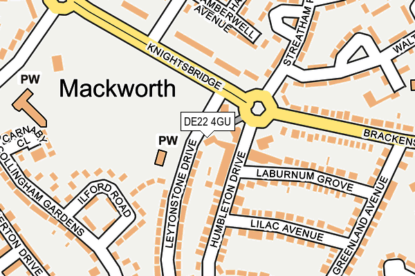
DE22 4GU is located in the Mackworth & New Zealand electoral ward, within the unitary authority of Derby and the English Parliamentary constituency of Derby North. The Sub Integrated Care Board (ICB) Location is NHS Derby and Derbyshire ICB - 15M and the police force is Derbyshire. This postcode has been in use since June 2009.


GetTheData
Source: OS OpenMap – Local (Ordnance Survey)
Source: OS VectorMap District (Ordnance Survey)
Licence: Open Government Licence (requires attribution)
| Easting | 432385 |
| Northing | 336433 |
| Latitude | 52.924356 |
| Longitude | -1.519733 |
GetTheData
Source: Open Postcode Geo
Licence: Open Government Licence
| Country | England |
| Postcode District | DE22 |
➜ See where DE22 is on a map ➜ Where is Derby? | |
GetTheData
Source: Land Registry Price Paid Data
Licence: Open Government Licence
Elevation or altitude of DE22 4GU as distance above sea level:
| Metres | Feet | |
|---|---|---|
| Elevation | 80m | 262ft |
Elevation is measured from the approximate centre of the postcode, to the nearest point on an OS contour line from OS Terrain 50, which has contour spacing of ten vertical metres.
➜ How high above sea level am I? Find the elevation of your current position using your device's GPS.
GetTheData
Source: Open Postcode Elevation
Licence: Open Government Licence
| Ward | Mackworth & New Zealand |
| Constituency | Derby North |
GetTheData
Source: ONS Postcode Database
Licence: Open Government Licence
| Humbleton Drive | Mackworth Estate | 50m |
| Humbleton Drive | Mackworth Estate | 54m |
| Osterley Green (Fulham Road) | Mackworth Estate | 201m |
| Osterley Green (Fulham Road) | Mackworth Estate | 208m |
| Hannover Square (Knightsbridge) | Mackworth Estate | 239m |
| Derby Station | 3.9km |
| Peartree Station | 4.4km |
GetTheData
Source: NaPTAN
Licence: Open Government Licence
| Percentage of properties with Next Generation Access | 100.0% |
| Percentage of properties with Superfast Broadband | 100.0% |
| Percentage of properties with Ultrafast Broadband | 0.0% |
| Percentage of properties with Full Fibre Broadband | 0.0% |
Superfast Broadband is between 30Mbps and 300Mbps
Ultrafast Broadband is > 300Mbps
| Percentage of properties unable to receive 2Mbps | 0.0% |
| Percentage of properties unable to receive 5Mbps | 0.0% |
| Percentage of properties unable to receive 10Mbps | 0.0% |
| Percentage of properties unable to receive 30Mbps | 0.0% |
GetTheData
Source: Ofcom
Licence: Ofcom Terms of Use (requires attribution)
GetTheData
Source: ONS Postcode Database
Licence: Open Government Licence


➜ Get more ratings from the Food Standards Agency
GetTheData
Source: Food Standards Agency
Licence: FSA terms & conditions
| Last Collection | |||
|---|---|---|---|
| Location | Mon-Fri | Sat | Distance |
| Fulham Road | 17:30 | 11:00 | 203m |
| Brackensdale Avenue | 17:30 | 11:00 | 286m |
| Prince Charles Avenue Tso | 17:30 | 11:30 | 443m |
GetTheData
Source: Dracos
Licence: Creative Commons Attribution-ShareAlike
The below table lists the International Territorial Level (ITL) codes (formerly Nomenclature of Territorial Units for Statistics (NUTS) codes) and Local Administrative Units (LAU) codes for DE22 4GU:
| ITL 1 Code | Name |
|---|---|
| TLF | East Midlands (England) |
| ITL 2 Code | Name |
| TLF1 | Derbyshire and Nottinghamshire |
| ITL 3 Code | Name |
| TLF11 | Derby |
| LAU 1 Code | Name |
| E06000015 | Derby |
GetTheData
Source: ONS Postcode Directory
Licence: Open Government Licence
The below table lists the Census Output Area (OA), Lower Layer Super Output Area (LSOA), and Middle Layer Super Output Area (MSOA) for DE22 4GU:
| Code | Name | |
|---|---|---|
| OA | E00068413 | |
| LSOA | E01013552 | Derby 009C |
| MSOA | E02002804 | Derby 009 |
GetTheData
Source: ONS Postcode Directory
Licence: Open Government Licence
| DE22 4AT | Humbleton Drive | 62m |
| DE22 4GF | Leytonstone Drive | 103m |
| DE22 4GT | Ilford Walk | 115m |
| DE22 4AU | Humbleton Drive | 132m |
| DE22 4AX | Laburnum Grove | 144m |
| DE22 4AW | Laburnum Grove | 151m |
| DE22 4GH | Knightsbridge | 153m |
| DE22 4GE | Leytonstone Drive | 154m |
| DE22 4AR | Lilac Avenue | 155m |
| DE22 4GN | Camberwell Avenue | 161m |
GetTheData
Source: Open Postcode Geo; Land Registry Price Paid Data
Licence: Open Government Licence