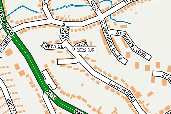
DE22 3JR lies on Louvain Road in Derby. DE22 3JR is located in the Abbey electoral ward, within the unitary authority of Derby and the English Parliamentary constituency of Derby North. The Sub Integrated Care Board (ICB) Location is NHS Derby and Derbyshire ICB - 15M and the police force is Derbyshire. This postcode has been in use since August 1992.


GetTheData
Source: OS OpenMap – Local (Ordnance Survey)
Source: OS VectorMap District (Ordnance Survey)
Licence: Open Government Licence (requires attribution)
| Easting | 433471 |
| Northing | 335020 |
| Latitude | 52.911589 |
| Longitude | -1.503725 |
GetTheData
Source: Open Postcode Geo
Licence: Open Government Licence
| Street | Louvain Road |
| Town/City | Derby |
| Country | England |
| Postcode District | DE22 |
➜ See where DE22 is on a map ➜ Where is Derby? | |
GetTheData
Source: Land Registry Price Paid Data
Licence: Open Government Licence
Elevation or altitude of DE22 3JR as distance above sea level:
| Metres | Feet | |
|---|---|---|
| Elevation | 80m | 262ft |
Elevation is measured from the approximate centre of the postcode, to the nearest point on an OS contour line from OS Terrain 50, which has contour spacing of ten vertical metres.
➜ How high above sea level am I? Find the elevation of your current position using your device's GPS.
GetTheData
Source: Open Postcode Elevation
Licence: Open Government Licence
| Ward | Abbey |
| Constituency | Derby North |
GetTheData
Source: ONS Postcode Database
Licence: Open Government Licence
| Louvain Road (St Albans Road) | California | 118m |
| St Swithins Close (St Albans Road) | California | 171m |
| St Cuthberts Road (St Albans Road) | California | 195m |
| St Swithins Close (St Albans Road) | California | 198m |
| Constable Lane (Bretton Avenue) | Littleover | 302m |
| Peartree Station | 2.6km |
| Derby Station | 2.8km |
GetTheData
Source: NaPTAN
Licence: Open Government Licence
| Percentage of properties with Next Generation Access | 100.0% |
| Percentage of properties with Superfast Broadband | 100.0% |
| Percentage of properties with Ultrafast Broadband | 100.0% |
| Percentage of properties with Full Fibre Broadband | 0.0% |
Superfast Broadband is between 30Mbps and 300Mbps
Ultrafast Broadband is > 300Mbps
| Median download speed | 40.0Mbps |
| Average download speed | 52.4Mbps |
| Maximum download speed | 100.00Mbps |
| Median upload speed | 10.0Mbps |
| Average upload speed | 8.4Mbps |
| Maximum upload speed | 18.93Mbps |
| Percentage of properties unable to receive 2Mbps | 0.0% |
| Percentage of properties unable to receive 5Mbps | 0.0% |
| Percentage of properties unable to receive 10Mbps | 0.0% |
| Percentage of properties unable to receive 30Mbps | 0.0% |
GetTheData
Source: Ofcom
Licence: Ofcom Terms of Use (requires attribution)
Estimated total energy consumption in DE22 3JR by fuel type, 2015.
| Consumption (kWh) | 158,195 |
|---|---|
| Meter count | 17 |
| Mean (kWh/meter) | 9,306 |
| Median (kWh/meter) | 7,962 |
GetTheData
Source: Postcode level gas estimates: 2015 (experimental)
Source: Postcode level electricity estimates: 2015 (experimental)
Licence: Open Government Licence
GetTheData
Source: ONS Postcode Database
Licence: Open Government Licence


➜ Get more ratings from the Food Standards Agency
GetTheData
Source: Food Standards Agency
Licence: FSA terms & conditions
| Last Collection | |||
|---|---|---|---|
| Location | Mon-Fri | Sat | Distance |
| St Albans Road | 17:30 | 12:00 | 141m |
| Bretton Avenue | 17:30 | 12:00 | 306m |
| Manor Cross Roads | 17:30 | 10:30 | 454m |
GetTheData
Source: Dracos
Licence: Creative Commons Attribution-ShareAlike
The below table lists the International Territorial Level (ITL) codes (formerly Nomenclature of Territorial Units for Statistics (NUTS) codes) and Local Administrative Units (LAU) codes for DE22 3JR:
| ITL 1 Code | Name |
|---|---|
| TLF | East Midlands (England) |
| ITL 2 Code | Name |
| TLF1 | Derbyshire and Nottinghamshire |
| ITL 3 Code | Name |
| TLF11 | Derby |
| LAU 1 Code | Name |
| E06000015 | Derby |
GetTheData
Source: ONS Postcode Directory
Licence: Open Government Licence
The below table lists the Census Output Area (OA), Lower Layer Super Output Area (LSOA), and Middle Layer Super Output Area (MSOA) for DE22 3JR:
| Code | Name | |
|---|---|---|
| OA | E00067931 | |
| LSOA | E01013455 | Derby 017A |
| MSOA | E02002812 | Derby 017 |
GetTheData
Source: ONS Postcode Directory
Licence: Open Government Licence
| DE22 3JS | Namur Close | 63m |
| DE22 3JT | St Quentin Close | 76m |
| DE22 3LF | St Swithins Close | 89m |
| DE22 3FX | Bishops Green | 95m |
| DE22 3JU | Crecy Close | 118m |
| DE23 6BS | Manor Road | 128m |
| DE22 3JL | St Albans Road | 135m |
| DE22 3LH | St Davids Close | 145m |
| DE23 6DA | Louvain Road | 150m |
| DE22 3LG | St Swithins Close | 155m |
GetTheData
Source: Open Postcode Geo; Land Registry Price Paid Data
Licence: Open Government Licence