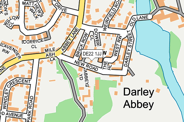
DE22 1JJ lies on New Road in Darley Abbey, Derby. DE22 1JJ is located in the Darley electoral ward, within the unitary authority of Derby and the English Parliamentary constituency of Derby North. The Sub Integrated Care Board (ICB) Location is NHS Derby and Derbyshire ICB - 15M and the police force is Derbyshire. This postcode has been in use since July 2003.


GetTheData
Source: OS OpenMap – Local (Ordnance Survey)
Source: OS VectorMap District (Ordnance Survey)
Licence: Open Government Licence (requires attribution)
| Easting | 435152 |
| Northing | 338416 |
| Latitude | 52.942008 |
| Longitude | -1.478363 |
GetTheData
Source: Open Postcode Geo
Licence: Open Government Licence
| Street | New Road |
| Locality | Darley Abbey |
| Town/City | Derby |
| Country | England |
| Postcode District | DE22 |
➜ See where DE22 is on a map ➜ Where is Derby? | |
GetTheData
Source: Land Registry Price Paid Data
Licence: Open Government Licence
Elevation or altitude of DE22 1JJ as distance above sea level:
| Metres | Feet | |
|---|---|---|
| Elevation | 60m | 197ft |
Elevation is measured from the approximate centre of the postcode, to the nearest point on an OS contour line from OS Terrain 50, which has contour spacing of ten vertical metres.
➜ How high above sea level am I? Find the elevation of your current position using your device's GPS.
GetTheData
Source: Open Postcode Elevation
Licence: Open Government Licence
| Ward | Darley |
| Constituency | Derby North |
GetTheData
Source: ONS Postcode Database
Licence: Open Government Licence
| Abbey Lane | Darley Abbey | 107m |
| Abbey Lane | Darley Abbey | 121m |
| Darley Park Road (Mileash Lane) | Darley Abbey | 211m |
| Walter Evans School (Darley Abbey Drive) | Darley Abbey | 366m |
| St Matthews Church (Church Lane) | Darley Abbey | 368m |
| Derby Station | 3km |
| Spondon Station | 5.6km |
GetTheData
Source: NaPTAN
Licence: Open Government Licence
| Percentage of properties with Next Generation Access | 100.0% |
| Percentage of properties with Superfast Broadband | 100.0% |
| Percentage of properties with Ultrafast Broadband | 100.0% |
| Percentage of properties with Full Fibre Broadband | 0.0% |
Superfast Broadband is between 30Mbps and 300Mbps
Ultrafast Broadband is > 300Mbps
| Percentage of properties unable to receive 2Mbps | 0.0% |
| Percentage of properties unable to receive 5Mbps | 0.0% |
| Percentage of properties unable to receive 10Mbps | 0.0% |
| Percentage of properties unable to receive 30Mbps | 0.0% |
GetTheData
Source: Ofcom
Licence: Ofcom Terms of Use (requires attribution)
GetTheData
Source: ONS Postcode Database
Licence: Open Government Licence


➜ Get more ratings from the Food Standards Agency
GetTheData
Source: Food Standards Agency
Licence: FSA terms & conditions
| Last Collection | |||
|---|---|---|---|
| Location | Mon-Fri | Sat | Distance |
| Darley Abbey Village | 17:30 | 11:00 | 154m |
| Church Lane | 17:30 | 11:00 | 568m |
| The Boundary | 17:30 | 10:30 | 587m |
GetTheData
Source: Dracos
Licence: Creative Commons Attribution-ShareAlike
The below table lists the International Territorial Level (ITL) codes (formerly Nomenclature of Territorial Units for Statistics (NUTS) codes) and Local Administrative Units (LAU) codes for DE22 1JJ:
| ITL 1 Code | Name |
|---|---|
| TLF | East Midlands (England) |
| ITL 2 Code | Name |
| TLF1 | Derbyshire and Nottinghamshire |
| ITL 3 Code | Name |
| TLF11 | Derby |
| LAU 1 Code | Name |
| E06000015 | Derby |
GetTheData
Source: ONS Postcode Directory
Licence: Open Government Licence
The below table lists the Census Output Area (OA), Lower Layer Super Output Area (LSOA), and Middle Layer Super Output Area (MSOA) for DE22 1JJ:
| Code | Name | |
|---|---|---|
| OA | E00068306 | |
| LSOA | E01013526 | Derby 005A |
| MSOA | E02002800 | Derby 005 |
GetTheData
Source: ONS Postcode Directory
Licence: Open Government Licence
| DE22 1JL | New Road | 18m |
| DE22 1JQ | Abbot Mews | 36m |
| DE22 1DR | New Road | 36m |
| DE22 1DT | The Hill | 54m |
| DE22 1DP | North Row | 71m |
| DE22 1DQ | Brick Row | 75m |
| DE22 1DW | Hill Square | 78m |
| DE22 1DS | Abbey Yard | 92m |
| DE22 1DN | West Row | 108m |
| DE22 1DU | Poplar Row | 108m |
GetTheData
Source: Open Postcode Geo; Land Registry Price Paid Data
Licence: Open Government Licence