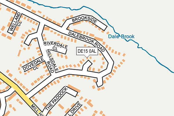
DE15 0AL lies on Millersdale Close in Burton-on-trent. DE15 0AL is located in the Winshill electoral ward, within the local authority district of East Staffordshire and the English Parliamentary constituency of Burton. The Sub Integrated Care Board (ICB) Location is NHS Staffordshire and Stoke-on-Trent ICB - 05D and the police force is Staffordshire. This postcode has been in use since January 1980.


GetTheData
Source: OS OpenMap – Local (Ordnance Survey)
Source: OS VectorMap District (Ordnance Survey)
Licence: Open Government Licence (requires attribution)
| Easting | 426703 |
| Northing | 324029 |
| Latitude | 52.813148 |
| Longitude | -1.605264 |
GetTheData
Source: Open Postcode Geo
Licence: Open Government Licence
| Street | Millersdale Close |
| Town/City | Burton-on-trent |
| Country | England |
| Postcode District | DE15 |
➜ See where DE15 is on a map ➜ Where is Burton upon Trent? | |
GetTheData
Source: Land Registry Price Paid Data
Licence: Open Government Licence
Elevation or altitude of DE15 0AL as distance above sea level:
| Metres | Feet | |
|---|---|---|
| Elevation | 70m | 230ft |
Elevation is measured from the approximate centre of the postcode, to the nearest point on an OS contour line from OS Terrain 50, which has contour spacing of ten vertical metres.
➜ How high above sea level am I? Find the elevation of your current position using your device's GPS.
GetTheData
Source: Open Postcode Elevation
Licence: Open Government Licence
| Ward | Winshill |
| Constituency | Burton |
GetTheData
Source: ONS Postcode Database
Licence: Open Government Licence
2019 25 JUN £227,000 |
2014 17 OCT £155,000 |
4, MILLERSDALE CLOSE, BURTON-ON-TRENT, DE15 0AL 2013 6 SEP £167,000 |
➜ Burton upon Trent house prices
GetTheData
Source: HM Land Registry Price Paid Data
Licence: Contains HM Land Registry data © Crown copyright and database right 2025. This data is licensed under the Open Government Licence v3.0.
| Cheedale Close (Hillsdale Rd) | Winshill | 188m |
| Hillsdale Road (Dalebrook Road) | Winshill | 224m |
| Abbot Beyne School (Mill Hill Lane) | Winshill | 322m |
| Newton Road (Dalebrook Road) | Winshill | 337m |
| Dalebrook Road (Newton Road) | Winshill | 374m |
| Burton-on-Trent Station | 2.6km |
| Willington Station | 5.3km |
GetTheData
Source: NaPTAN
Licence: Open Government Licence
| Percentage of properties with Next Generation Access | 100.0% |
| Percentage of properties with Superfast Broadband | 100.0% |
| Percentage of properties with Ultrafast Broadband | 0.0% |
| Percentage of properties with Full Fibre Broadband | 0.0% |
Superfast Broadband is between 30Mbps and 300Mbps
Ultrafast Broadband is > 300Mbps
| Median download speed | 54.3Mbps |
| Average download speed | 43.4Mbps |
| Maximum download speed | 79.96Mbps |
| Median upload speed | 10.5Mbps |
| Average upload speed | 10.1Mbps |
| Maximum upload speed | 20.00Mbps |
| Percentage of properties unable to receive 2Mbps | 0.0% |
| Percentage of properties unable to receive 5Mbps | 0.0% |
| Percentage of properties unable to receive 10Mbps | 0.0% |
| Percentage of properties unable to receive 30Mbps | 0.0% |
GetTheData
Source: Ofcom
Licence: Ofcom Terms of Use (requires attribution)
GetTheData
Source: ONS Postcode Database
Licence: Open Government Licence


➜ Get more ratings from the Food Standards Agency
GetTheData
Source: Food Standards Agency
Licence: FSA terms & conditions
| Last Collection | |||
|---|---|---|---|
| Location | Mon-Fri | Sat | Distance |
| Dalebrook Road | 16:00 | 10:30 | 124m |
| Newton Road | 16:00 | 10:30 | 408m |
| Churchill Street | 16:00 | 10:30 | 550m |
GetTheData
Source: Dracos
Licence: Creative Commons Attribution-ShareAlike
The below table lists the International Territorial Level (ITL) codes (formerly Nomenclature of Territorial Units for Statistics (NUTS) codes) and Local Administrative Units (LAU) codes for DE15 0AL:
| ITL 1 Code | Name |
|---|---|
| TLG | West Midlands (England) |
| ITL 2 Code | Name |
| TLG2 | Shropshire and Staffordshire |
| ITL 3 Code | Name |
| TLG24 | Staffordshire CC |
| LAU 1 Code | Name |
| E07000193 | East Staffordshire |
GetTheData
Source: ONS Postcode Directory
Licence: Open Government Licence
The below table lists the Census Output Area (OA), Lower Layer Super Output Area (LSOA), and Middle Layer Super Output Area (MSOA) for DE15 0AL:
| Code | Name | |
|---|---|---|
| OA | E00150159 | |
| LSOA | E01029469 | East Staffordshire 010B |
| MSOA | E02006140 | East Staffordshire 010 |
GetTheData
Source: ONS Postcode Directory
Licence: Open Government Licence
| DE15 0AD | Dalebrook Road | 47m |
| DE15 0AU | Riverdale Close | 103m |
| DE15 0AE | Dalebrook Road | 115m |
| DE15 0AJ | Monsaldale Close | 116m |
| DE15 0AH | Deepdale Close | 126m |
| DE15 0AB | Dalebrook Road | 127m |
| DE15 0AQ | Brookside | 128m |
| DE15 0AN | Hillsdale Road | 130m |
| DE15 0BD | Mill Hill Drive | 192m |
| DE15 0AW | Dovedale Close | 207m |
GetTheData
Source: Open Postcode Geo; Land Registry Price Paid Data
Licence: Open Government Licence