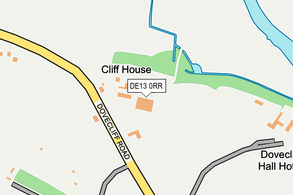
DE13 0RR is located in the Dove electoral ward, within the local authority district of East Staffordshire and the English Parliamentary constituency of Burton. The Sub Integrated Care Board (ICB) Location is NHS Staffordshire and Stoke-on-Trent ICB - 05D and the police force is Staffordshire. This postcode has been in use since March 2014.


GetTheData
Source: OS OpenMap – Local (Ordnance Survey)
Source: OS VectorMap District (Ordnance Survey)
Licence: Open Government Licence (requires attribution)
| Easting | 425495 |
| Northing | 327564 |
| Latitude | 52.845001 |
| Longitude | -1.622907 |
GetTheData
Source: Open Postcode Geo
Licence: Open Government Licence
| Country | England |
| Postcode District | DE13 |
➜ See where DE13 is on a map | |
GetTheData
Source: Land Registry Price Paid Data
Licence: Open Government Licence
Elevation or altitude of DE13 0RR as distance above sea level:
| Metres | Feet | |
|---|---|---|
| Elevation | 50m | 164ft |
Elevation is measured from the approximate centre of the postcode, to the nearest point on an OS contour line from OS Terrain 50, which has contour spacing of ten vertical metres.
➜ How high above sea level am I? Find the elevation of your current position using your device's GPS.
GetTheData
Source: Open Postcode Elevation
Licence: Open Government Licence
| Ward | Dove |
| Constituency | Burton |
GetTheData
Source: ONS Postcode Database
Licence: Open Government Licence
| Dovecliff House (Dovecliffe Road) | Rolleston On Dove | 98m |
| Dovecliff House (Dovecliff Road) | Rolleston On Dove | 111m |
| Rolleston Cricket Club (Dovecliff Road) | Rolleston On Dove | 386m |
| Rolleston Cricket Club (Dovecliff Road) | Rolleston On Dove | 422m |
| Dovecliff Crescent (Dovecliff Road) | Clay Mills | 625m |
| Willington Station | 4.1km |
| Tutbury & Hatton Station | 4.5km |
| Burton-on-Trent Station | 4.6km |
GetTheData
Source: NaPTAN
Licence: Open Government Licence
GetTheData
Source: ONS Postcode Database
Licence: Open Government Licence


➜ Get more ratings from the Food Standards Agency
GetTheData
Source: Food Standards Agency
Licence: FSA terms & conditions
| Last Collection | |||
|---|---|---|---|
| Location | Mon-Fri | Sat | Distance |
| Rolleston | 17:30 | 10:15 | 723m |
| Church Road | 17:30 | 08:45 | 807m |
| Clay Mills Road | 17:30 | 08:45 | 885m |
GetTheData
Source: Dracos
Licence: Creative Commons Attribution-ShareAlike
The below table lists the International Territorial Level (ITL) codes (formerly Nomenclature of Territorial Units for Statistics (NUTS) codes) and Local Administrative Units (LAU) codes for DE13 0RR:
| ITL 1 Code | Name |
|---|---|
| TLG | West Midlands (England) |
| ITL 2 Code | Name |
| TLG2 | Shropshire and Staffordshire |
| ITL 3 Code | Name |
| TLG24 | Staffordshire CC |
| LAU 1 Code | Name |
| E07000193 | East Staffordshire |
GetTheData
Source: ONS Postcode Directory
Licence: Open Government Licence
The below table lists the Census Output Area (OA), Lower Layer Super Output Area (LSOA), and Middle Layer Super Output Area (MSOA) for DE13 0RR:
| Code | Name | |
|---|---|---|
| OA | E00150010 | |
| LSOA | E01029443 | East Staffordshire 004A |
| MSOA | E02006134 | East Staffordshire 004 |
GetTheData
Source: ONS Postcode Directory
Licence: Open Government Licence
| DE13 9AU | Dovecliff Road | 397m |
| DE13 0DJ | Dovecliff Road | 401m |
| DE13 9AR | Walford Road | 534m |
| DE13 9AT | South Hill | 578m |
| DE13 9AP | Walford Road | 656m |
| DE13 0JH | Dovecliff Crescent | 658m |
| DE13 0JJ | St Marys Drive | 681m |
| DE13 9AS | Fairfield Avenue | 703m |
| DE13 0DH | Dovecliff Road | 714m |
| DE13 0HJ | Priorylands | 730m |
GetTheData
Source: Open Postcode Geo; Land Registry Price Paid Data
Licence: Open Government Licence