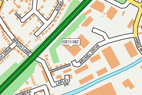
DE13 0BZ is located in the Stretton electoral ward, within the local authority district of East Staffordshire and the English Parliamentary constituency of Burton. The Sub Integrated Care Board (ICB) Location is NHS Staffordshire and Stoke-on-Trent ICB - 05D and the police force is Staffordshire. This postcode has been in use since June 2000.


GetTheData
Source: OS OpenMap – Local (Ordnance Survey)
Source: OS VectorMap District (Ordnance Survey)
Licence: Open Government Licence (requires attribution)
| Easting | 425450 |
| Northing | 325924 |
| Latitude | 52.830261 |
| Longitude | -1.623702 |
GetTheData
Source: Open Postcode Geo
Licence: Open Government Licence
| Country | England |
| Postcode District | DE13 |
➜ See where DE13 is on a map ➜ Where is Stretton? | |
GetTheData
Source: Land Registry Price Paid Data
Licence: Open Government Licence
Elevation or altitude of DE13 0BZ as distance above sea level:
| Metres | Feet | |
|---|---|---|
| Elevation | 50m | 164ft |
Elevation is measured from the approximate centre of the postcode, to the nearest point on an OS contour line from OS Terrain 50, which has contour spacing of ten vertical metres.
➜ How high above sea level am I? Find the elevation of your current position using your device's GPS.
GetTheData
Source: Open Postcode Elevation
Licence: Open Government Licence
| Ward | Stretton |
| Constituency | Burton |
GetTheData
Source: ONS Postcode Database
Licence: Open Government Licence
| Moor Furlong (Hillfield Lane) | Stretton | 316m |
| Fairham Road (Hillfield Lane) | Stretton | 324m |
| Methodist Church (Main St) | Stretton | 337m |
| Methodist Church (Main St) | Stretton | 349m |
| Britannia Drive (Princess Way) | Stretton | 383m |
| Burton-on-Trent Station | 3km |
| Willington Station | 4.8km |
| Tutbury & Hatton Station | 5.5km |
GetTheData
Source: NaPTAN
Licence: Open Government Licence
GetTheData
Source: ONS Postcode Database
Licence: Open Government Licence


➜ Get more ratings from the Food Standards Agency
GetTheData
Source: Food Standards Agency
Licence: FSA terms & conditions
| Last Collection | |||
|---|---|---|---|
| Location | Mon-Fri | Sat | Distance |
| Stretton Post Office | 18:00 | 11:15 | 357m |
| Stretton | 17:30 | 08:30 | 373m |
| Bridge Street | 17:30 | 08:45 | 463m |
GetTheData
Source: Dracos
Licence: Creative Commons Attribution-ShareAlike
The below table lists the International Territorial Level (ITL) codes (formerly Nomenclature of Territorial Units for Statistics (NUTS) codes) and Local Administrative Units (LAU) codes for DE13 0BZ:
| ITL 1 Code | Name |
|---|---|
| TLG | West Midlands (England) |
| ITL 2 Code | Name |
| TLG2 | Shropshire and Staffordshire |
| ITL 3 Code | Name |
| TLG24 | Staffordshire CC |
| LAU 1 Code | Name |
| E07000193 | East Staffordshire |
GetTheData
Source: ONS Postcode Directory
Licence: Open Government Licence
The below table lists the Census Output Area (OA), Lower Layer Super Output Area (LSOA), and Middle Layer Super Output Area (MSOA) for DE13 0BZ:
| Code | Name | |
|---|---|---|
| OA | E00149927 | |
| LSOA | E01029428 | East Staffordshire 008C |
| MSOA | E02006138 | East Staffordshire 008 |
GetTheData
Source: ONS Postcode Directory
Licence: Open Government Licence
| DE13 0DN | Lapley Drive | 99m |
| DE13 0EE | Hurst Drive | 146m |
| DE13 0DU | Beech Lane | 160m |
| DE13 0ED | Hurst Drive | 207m |
| DE13 0EB | Hurst Drive | 229m |
| DE13 0DX | Beech Lane | 274m |
| DE13 0BN | Hillfield Lane | 275m |
| DE13 0BD | Carisbrook Drive | 280m |
| DE13 0FE | Beech Gardens | 294m |
| DE13 0DY | Beech Drive | 301m |
GetTheData
Source: Open Postcode Geo; Land Registry Price Paid Data
Licence: Open Government Licence