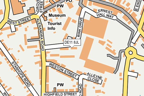
DE11 8JL lies on Rink Drive in Swadlincote. DE11 8JL is located in the Swadlincote electoral ward, within the local authority district of South Derbyshire and the English Parliamentary constituency of South Derbyshire. The Sub Integrated Care Board (ICB) Location is NHS Derby and Derbyshire ICB - 15M and the police force is Derbyshire. This postcode has been in use since January 1993.


GetTheData
Source: OS OpenMap – Local (Ordnance Survey)
Source: OS VectorMap District (Ordnance Survey)
Licence: Open Government Licence (requires attribution)
| Easting | 429953 |
| Northing | 319427 |
| Latitude | 52.771610 |
| Longitude | -1.557467 |
GetTheData
Source: Open Postcode Geo
Licence: Open Government Licence
| Street | Rink Drive |
| Town/City | Swadlincote |
| Country | England |
| Postcode District | DE11 |
➜ See where DE11 is on a map ➜ Where is Swadlincote? | |
GetTheData
Source: Land Registry Price Paid Data
Licence: Open Government Licence
Elevation or altitude of DE11 8JL as distance above sea level:
| Metres | Feet | |
|---|---|---|
| Elevation | 110m | 361ft |
Elevation is measured from the approximate centre of the postcode, to the nearest point on an OS contour line from OS Terrain 50, which has contour spacing of ten vertical metres.
➜ How high above sea level am I? Find the elevation of your current position using your device's GPS.
GetTheData
Source: Open Postcode Elevation
Licence: Open Government Licence
| Ward | Swadlincote |
| Constituency | South Derbyshire |
GetTheData
Source: ONS Postcode Database
Licence: Open Government Licence
| West Street (Alexandra Road) | Swadlincote | 158m |
| West Street (Alexandra Road) | Swadlincote | 173m |
| Highfield Street (Alexandra Road) | Swadlincote | 211m |
| Highfield Street (Alexandra Road) | Swadlincote | 224m |
| Coppice Side | Swadlincote | 234m |
GetTheData
Source: NaPTAN
Licence: Open Government Licence
| Median download speed | 80.0Mbps |
| Average download speed | 66.9Mbps |
| Maximum download speed | 80.00Mbps |
| Median upload speed | 20.0Mbps |
| Average upload speed | 16.2Mbps |
| Maximum upload speed | 20.00Mbps |
GetTheData
Source: Ofcom
Licence: Ofcom Terms of Use (requires attribution)
GetTheData
Source: ONS Postcode Database
Licence: Open Government Licence


➜ Get more ratings from the Food Standards Agency
GetTheData
Source: Food Standards Agency
Licence: FSA terms & conditions
| Last Collection | |||
|---|---|---|---|
| Location | Mon-Fri | Sat | Distance |
| Morrisons | 16:00 | 12:15 | 181m |
| Swadlincote Mspo Inter | 17:15 | 12:15 | 221m |
| Swadlincote Main Post Office | 18:30 | 12:15 | 224m |
GetTheData
Source: Dracos
Licence: Creative Commons Attribution-ShareAlike
The below table lists the International Territorial Level (ITL) codes (formerly Nomenclature of Territorial Units for Statistics (NUTS) codes) and Local Administrative Units (LAU) codes for DE11 8JL:
| ITL 1 Code | Name |
|---|---|
| TLF | East Midlands (England) |
| ITL 2 Code | Name |
| TLF1 | Derbyshire and Nottinghamshire |
| ITL 3 Code | Name |
| TLF13 | South and West Derbyshire |
| LAU 1 Code | Name |
| E07000039 | South Derbyshire |
GetTheData
Source: ONS Postcode Directory
Licence: Open Government Licence
The below table lists the Census Output Area (OA), Lower Layer Super Output Area (LSOA), and Middle Layer Super Output Area (MSOA) for DE11 8JL:
| Code | Name | |
|---|---|---|
| OA | E00100587 | |
| LSOA | E01019877 | South Derbyshire 009B |
| MSOA | E02004126 | South Derbyshire 009 |
GetTheData
Source: ONS Postcode Directory
Licence: Open Government Licence
| DE11 8JS | Rink Drive | 82m |
| DE11 9AT | Weston Street | 111m |
| DE11 9FQ | Coppice Side | 126m |
| DE11 9AZ | Alexandra Road | 146m |
| DE11 9GH | Alleyne Close | 151m |
| DE11 9AY | Alexandra Road | 162m |
| DE11 9BA | Majestic Place | 166m |
| DE11 8JJ | Ernest Hall Way | 187m |
| DE11 9DG | West Street | 188m |
| DE11 9AS | Highfield Street | 208m |
GetTheData
Source: Open Postcode Geo; Land Registry Price Paid Data
Licence: Open Government Licence