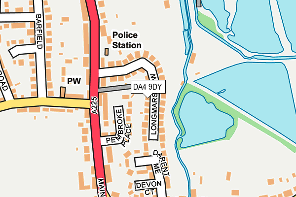
DA4 9DY lies on Longmarsh View in Sutton At Hone, Dartford. DA4 9DY is located in the Wilmington, Sutton-at-Hone & Hawley electoral ward, within the local authority district of Dartford and the English Parliamentary constituency of Dartford. The Sub Integrated Care Board (ICB) Location is NHS Kent and Medway ICB - 91Q and the police force is Kent. This postcode has been in use since January 1980.


GetTheData
Source: OS OpenMap – Local (Ordnance Survey)
Source: OS VectorMap District (Ordnance Survey)
Licence: Open Government Licence (requires attribution)
| Easting | 555843 |
| Northing | 169804 |
| Latitude | 51.405855 |
| Longitude | 0.239222 |
GetTheData
Source: Open Postcode Geo
Licence: Open Government Licence
| Street | Longmarsh View |
| Locality | Sutton At Hone |
| Town/City | Dartford |
| Country | England |
| Postcode District | DA4 |
➜ See where DA4 is on a map ➜ Where is Sutton at Hone? | |
GetTheData
Source: Land Registry Price Paid Data
Licence: Open Government Licence
Elevation or altitude of DA4 9DY as distance above sea level:
| Metres | Feet | |
|---|---|---|
| Elevation | 20m | 66ft |
Elevation is measured from the approximate centre of the postcode, to the nearest point on an OS contour line from OS Terrain 50, which has contour spacing of ten vertical metres.
➜ How high above sea level am I? Find the elevation of your current position using your device's GPS.
GetTheData
Source: Open Postcode Elevation
Licence: Open Government Licence
| Ward | Wilmington, Sutton-at-hone & Hawley |
| Constituency | Dartford |
GetTheData
Source: ONS Postcode Database
Licence: Open Government Licence
| The Ship (Main Road) | Sutton At Hone | 109m |
| The Ship (Main Road) | Sutton At Hone | 125m |
| Balmoral Road (Main Road) | Sutton At Hone | 297m |
| Cedar Drive (Main Road) | Sutton At Hone | 304m |
| Cedar Drive (Main Road) | Sutton At Hone | 340m |
| Farningham Road Station | 0.5km |
| Longfield Station | 4.4km |
| Dartford Station | 4.8km |
GetTheData
Source: NaPTAN
Licence: Open Government Licence
| Percentage of properties with Next Generation Access | 100.0% |
| Percentage of properties with Superfast Broadband | 100.0% |
| Percentage of properties with Ultrafast Broadband | 0.0% |
| Percentage of properties with Full Fibre Broadband | 0.0% |
Superfast Broadband is between 30Mbps and 300Mbps
Ultrafast Broadband is > 300Mbps
| Median download speed | 40.0Mbps |
| Average download speed | 36.9Mbps |
| Maximum download speed | 80.00Mbps |
| Median upload speed | 10.0Mbps |
| Average upload speed | 9.7Mbps |
| Maximum upload speed | 20.00Mbps |
| Percentage of properties unable to receive 2Mbps | 0.0% |
| Percentage of properties unable to receive 5Mbps | 0.0% |
| Percentage of properties unable to receive 10Mbps | 0.0% |
| Percentage of properties unable to receive 30Mbps | 0.0% |
GetTheData
Source: Ofcom
Licence: Ofcom Terms of Use (requires attribution)
Estimated total energy consumption in DA4 9DY by fuel type, 2015.
| Consumption (kWh) | 402,659 |
|---|---|
| Meter count | 28 |
| Mean (kWh/meter) | 14,381 |
| Median (kWh/meter) | 12,709 |
| Consumption (kWh) | 92,776 |
|---|---|
| Meter count | 25 |
| Mean (kWh/meter) | 3,711 |
| Median (kWh/meter) | 3,049 |
GetTheData
Source: Postcode level gas estimates: 2015 (experimental)
Source: Postcode level electricity estimates: 2015 (experimental)
Licence: Open Government Licence
GetTheData
Source: ONS Postcode Database
Licence: Open Government Licence


➜ Get more ratings from the Food Standards Agency
GetTheData
Source: Food Standards Agency
Licence: FSA terms & conditions
| Last Collection | |||
|---|---|---|---|
| Location | Mon-Fri | Sat | Distance |
| Sutton At Hone Post Office | 17:30 | 12:15 | 394m |
| Old Dartford Road | 16:00 | 12:00 | 1,046m |
| South Darenth Post Office | 17:00 | 12:15 | 1,904m |
GetTheData
Source: Dracos
Licence: Creative Commons Attribution-ShareAlike
The below table lists the International Territorial Level (ITL) codes (formerly Nomenclature of Territorial Units for Statistics (NUTS) codes) and Local Administrative Units (LAU) codes for DA4 9DY:
| ITL 1 Code | Name |
|---|---|
| TLJ | South East (England) |
| ITL 2 Code | Name |
| TLJ4 | Kent |
| ITL 3 Code | Name |
| TLJ43 | Kent Thames Gateway |
| LAU 1 Code | Name |
| E07000107 | Dartford |
GetTheData
Source: ONS Postcode Directory
Licence: Open Government Licence
The below table lists the Census Output Area (OA), Lower Layer Super Output Area (LSOA), and Middle Layer Super Output Area (MSOA) for DA4 9DY:
| Code | Name | |
|---|---|---|
| OA | E00122731 | |
| LSOA | E01024175 | Dartford 012E |
| MSOA | E02005039 | Dartford 012 |
GetTheData
Source: ONS Postcode Directory
Licence: Open Government Licence
| DA4 9DZ | Longmarsh View | 38m |
| DA4 9HR | Pembroke Place | 59m |
| DA4 9HW | Main Road | 102m |
| DA4 9EH | Darent Mead | 135m |
| DA4 9EF | Ship Lane | 162m |
| DA4 9HP | Main Road | 163m |
| DA4 9EG | Ship Lane | 174m |
| DA4 9HJ | Main Road | 179m |
| DA4 9EP | Devon Court | 194m |
| DA4 9EQ | Chapel Field Cottages | 237m |
GetTheData
Source: Open Postcode Geo; Land Registry Price Paid Data
Licence: Open Government Licence