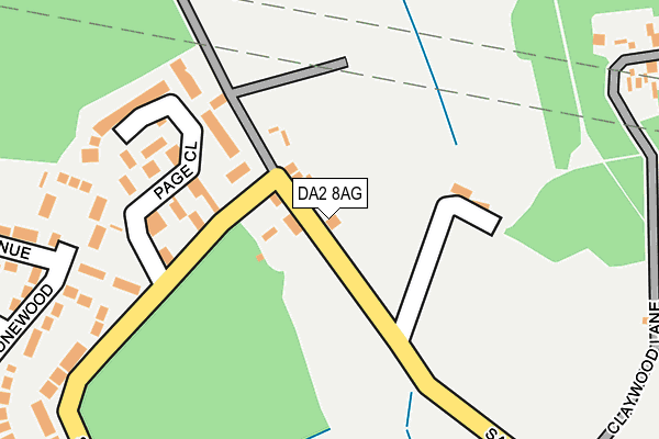
DA2 8AG is located in the Bean & Village Park electoral ward, within the local authority district of Dartford and the English Parliamentary constituency of Dartford. The Sub Integrated Care Board (ICB) Location is NHS Kent and Medway ICB - 91Q and the police force is Kent. This postcode has been in use since January 1980.


GetTheData
Source: OS OpenMap – Local (Ordnance Survey)
Source: OS VectorMap District (Ordnance Survey)
Licence: Open Government Licence (requires attribution)
| Easting | 559540 |
| Northing | 172378 |
| Latitude | 51.427953 |
| Longitude | 0.293517 |
GetTheData
Source: Open Postcode Geo
Licence: Open Government Licence
| Country | England |
| Postcode District | DA2 |
➜ See where DA2 is on a map ➜ Where is Bean? | |
GetTheData
Source: Land Registry Price Paid Data
Licence: Open Government Licence
Elevation or altitude of DA2 8AG as distance above sea level:
| Metres | Feet | |
|---|---|---|
| Elevation | 70m | 230ft |
Elevation is measured from the approximate centre of the postcode, to the nearest point on an OS contour line from OS Terrain 50, which has contour spacing of ten vertical metres.
➜ How high above sea level am I? Find the elevation of your current position using your device's GPS.
GetTheData
Source: Open Postcode Elevation
Licence: Open Government Licence
| Ward | Bean & Village Park |
| Constituency | Dartford |
GetTheData
Source: ONS Postcode Database
Licence: Open Government Licence
2023 6 APR £450,000 |
GetTheData
Source: HM Land Registry Price Paid Data
Licence: Contains HM Land Registry data © Crown copyright and database right 2025. This data is licensed under the Open Government Licence v3.0.
| Bramble Avenue (Beacon Drive) | Bean | 504m |
| Bramble Avenue (Beacon Drive) | Bean | 509m |
| School (School Lane) | Bean | 530m |
| School (School Lane) | Bean | 569m |
| Black Horse (High Street) | Bean | 655m |
| Ebbsfleet International Station | 2.5km |
| Swanscombe Station | 2.6km |
| Greenhithe for Bluewater Station | 2.7km |
GetTheData
Source: NaPTAN
Licence: Open Government Licence
| Percentage of properties with Next Generation Access | 0.0% |
| Percentage of properties with Superfast Broadband | 0.0% |
| Percentage of properties with Ultrafast Broadband | 0.0% |
| Percentage of properties with Full Fibre Broadband | 0.0% |
Superfast Broadband is between 30Mbps and 300Mbps
Ultrafast Broadband is > 300Mbps
| Percentage of properties unable to receive 2Mbps | 100.0% |
| Percentage of properties unable to receive 5Mbps | 100.0% |
| Percentage of properties unable to receive 10Mbps | 100.0% |
| Percentage of properties unable to receive 30Mbps | 100.0% |
GetTheData
Source: Ofcom
Licence: Ofcom Terms of Use (requires attribution)
GetTheData
Source: ONS Postcode Database
Licence: Open Government Licence


➜ Get more ratings from the Food Standards Agency
GetTheData
Source: Food Standards Agency
Licence: FSA terms & conditions
| Last Collection | |||
|---|---|---|---|
| Location | Mon-Fri | Sat | Distance |
| The Thrift | 17:30 | 11:30 | 480m |
| Beacon Drive | 17:30 | 11:30 | 593m |
| Bean Post Office | 17:30 | 11:45 | 653m |
GetTheData
Source: Dracos
Licence: Creative Commons Attribution-ShareAlike
The below table lists the International Territorial Level (ITL) codes (formerly Nomenclature of Territorial Units for Statistics (NUTS) codes) and Local Administrative Units (LAU) codes for DA2 8AG:
| ITL 1 Code | Name |
|---|---|
| TLJ | South East (England) |
| ITL 2 Code | Name |
| TLJ4 | Kent |
| ITL 3 Code | Name |
| TLJ43 | Kent Thames Gateway |
| LAU 1 Code | Name |
| E07000107 | Dartford |
GetTheData
Source: ONS Postcode Directory
Licence: Open Government Licence
The below table lists the Census Output Area (OA), Lower Layer Super Output Area (LSOA), and Middle Layer Super Output Area (MSOA) for DA2 8AG:
| Code | Name | |
|---|---|---|
| OA | E00122517 | |
| LSOA | E01024134 | Dartford 012B |
| MSOA | E02005039 | Dartford 012 |
GetTheData
Source: ONS Postcode Directory
Licence: Open Government Licence
| DA2 8DB | Old Stable Yard | 43m |
| DA2 8AJ | Sandy Lane | 51m |
| DA2 8BX | Page Close | 153m |
| DA2 8BZ | Stonewood | 250m |
| DA2 8AL | School Lane | 283m |
| DA2 8BY | Stonewood | 359m |
| DA2 8BP | Bramble Avenue | 375m |
| DA2 8BN | Beacon Drive | 378m |
| DA2 8BW | Beacon Drive | 422m |
| DA2 8BL | The Thrift | 428m |
GetTheData
Source: Open Postcode Geo; Land Registry Price Paid Data
Licence: Open Government Licence