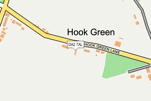
DA2 7AL lies on Hook Green Lane in Dartford. DA2 7AL is located in the Maypole & Leyton Cross electoral ward, within the local authority district of Dartford and the English Parliamentary constituency of Dartford. The Sub Integrated Care Board (ICB) Location is NHS Kent and Medway ICB - 91Q and the police force is Kent. This postcode has been in use since January 1980.


GetTheData
Source: OS OpenMap – Local (Ordnance Survey)
Source: OS VectorMap District (Ordnance Survey)
Licence: Open Government Licence (requires attribution)
| Easting | 551946 |
| Northing | 171978 |
| Latitude | 51.426445 |
| Longitude | 0.184196 |
GetTheData
Source: Open Postcode Geo
Licence: Open Government Licence
| Street | Hook Green Lane |
| Town/City | Dartford |
| Country | England |
| Postcode District | DA2 |
➜ See where DA2 is on a map ➜ Where is Hook Green? | |
GetTheData
Source: Land Registry Price Paid Data
Licence: Open Government Licence
Elevation or altitude of DA2 7AL as distance above sea level:
| Metres | Feet | |
|---|---|---|
| Elevation | 40m | 131ft |
Elevation is measured from the approximate centre of the postcode, to the nearest point on an OS contour line from OS Terrain 50, which has contour spacing of ten vertical metres.
➜ How high above sea level am I? Find the elevation of your current position using your device's GPS.
GetTheData
Source: Open Postcode Elevation
Licence: Open Government Licence
| Ward | Maypole & Leyton Cross |
| Constituency | Dartford |
GetTheData
Source: ONS Postcode Database
Licence: Open Government Licence
| Hook Green Lane (Birchwood Road) | Joydens Wood | 284m |
| Hook Green Lane (Leyton Cross Road) | Joydens Wood | 315m |
| Cherry Tree Lane (Leyton Cross Road) | Joydens Wood | 370m |
| Birchwood Drive (Birchwood Road) | Joydens Wood | 394m |
| Cherry Tree Lane (Leyton Cross Road) | Joydens Wood | 407m |
| Crayford Station | 2.5km |
| Bexley Station | 3km |
| Dartford Station | 3.4km |
GetTheData
Source: NaPTAN
Licence: Open Government Licence
| Percentage of properties with Next Generation Access | 100.0% |
| Percentage of properties with Superfast Broadband | 0.0% |
| Percentage of properties with Ultrafast Broadband | 0.0% |
| Percentage of properties with Full Fibre Broadband | 0.0% |
Superfast Broadband is between 30Mbps and 300Mbps
Ultrafast Broadband is > 300Mbps
| Median download speed | 18.4Mbps |
| Average download speed | 18.1Mbps |
| Maximum download speed | 22.57Mbps |
| Median upload speed | 2.2Mbps |
| Average upload speed | 2.7Mbps |
| Maximum upload speed | 4.55Mbps |
| Percentage of properties unable to receive 2Mbps | 0.0% |
| Percentage of properties unable to receive 5Mbps | 0.0% |
| Percentage of properties unable to receive 10Mbps | 0.0% |
| Percentage of properties unable to receive 30Mbps | 100.0% |
GetTheData
Source: Ofcom
Licence: Ofcom Terms of Use (requires attribution)
GetTheData
Source: ONS Postcode Database
Licence: Open Government Licence


➜ Get more ratings from the Food Standards Agency
GetTheData
Source: Food Standards Agency
Licence: FSA terms & conditions
| Last Collection | |||
|---|---|---|---|
| Location | Mon-Fri | Sat | Distance |
| Tile Kiln Lane | 17:30 | 12:00 | 294m |
| Leyton Cross Road Post Office | 17:30 | 11:15 | 593m |
| Joydens Wood Post Office | 17:30 | 11:45 | 1,187m |
GetTheData
Source: Dracos
Licence: Creative Commons Attribution-ShareAlike
The below table lists the International Territorial Level (ITL) codes (formerly Nomenclature of Territorial Units for Statistics (NUTS) codes) and Local Administrative Units (LAU) codes for DA2 7AL:
| ITL 1 Code | Name |
|---|---|
| TLJ | South East (England) |
| ITL 2 Code | Name |
| TLJ4 | Kent |
| ITL 3 Code | Name |
| TLJ43 | Kent Thames Gateway |
| LAU 1 Code | Name |
| E07000107 | Dartford |
GetTheData
Source: ONS Postcode Directory
Licence: Open Government Licence
The below table lists the Census Output Area (OA), Lower Layer Super Output Area (LSOA), and Middle Layer Super Output Area (MSOA) for DA2 7AL:
| Code | Name | |
|---|---|---|
| OA | E00122796 | |
| LSOA | E01024188 | Dartford 011C |
| MSOA | E02005038 | Dartford 011 |
GetTheData
Source: ONS Postcode Directory
Licence: Open Government Licence
| DA2 7AJ | Hook Green Lane | 120m |
| DA2 7HF | Birchwood Road | 321m |
| DA2 7HE | Birchwood Road | 385m |
| DA2 7AN | Leyton Cross Road | 410m |
| DA2 7BE | Wallis Close | 415m |
| DA2 7AE | Cherry Tree Lane | 430m |
| DA2 7AZ | Tredegar Road | 434m |
| DA5 2JF | Tile Kiln Lane | 461m |
| DA5 2JD | Park Way | 477m |
| DA2 7AW | Leyton Cross Road | 508m |
GetTheData
Source: Open Postcode Geo; Land Registry Price Paid Data
Licence: Open Government Licence