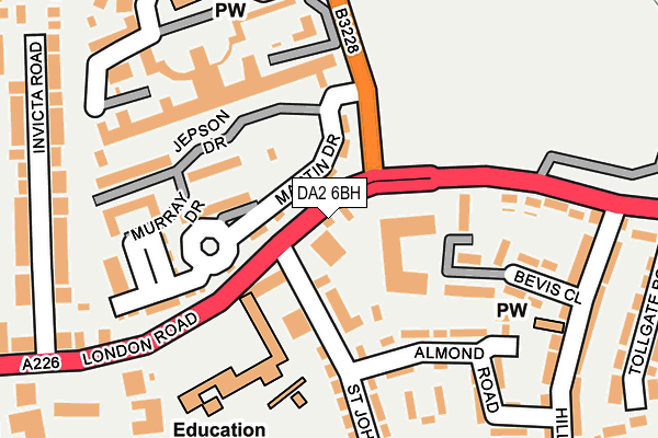
DA2 6BH is located in the Stone House electoral ward, within the local authority district of Dartford and the English Parliamentary constituency of Dartford. The Sub Integrated Care Board (ICB) Location is NHS Kent and Medway ICB - 91Q and the police force is Kent. This postcode has been in use since January 1980.


GetTheData
Source: OS OpenMap – Local (Ordnance Survey)
Source: OS VectorMap District (Ordnance Survey)
Licence: Open Government Licence (requires attribution)
| Easting | 556239 |
| Northing | 174038 |
| Latitude | 51.443787 |
| Longitude | 0.246805 |
GetTheData
Source: Open Postcode Geo
Licence: Open Government Licence
| Country | England |
| Postcode District | DA2 |
➜ See where DA2 is on a map ➜ Where is Dartford? | |
GetTheData
Source: Land Registry Price Paid Data
Licence: Open Government Licence
Elevation or altitude of DA2 6BH as distance above sea level:
| Metres | Feet | |
|---|---|---|
| Elevation | 30m | 98ft |
Elevation is measured from the approximate centre of the postcode, to the nearest point on an OS contour line from OS Terrain 50, which has contour spacing of ten vertical metres.
➜ How high above sea level am I? Find the elevation of your current position using your device's GPS.
GetTheData
Source: Open Postcode Elevation
Licence: Open Government Licence
| Ward | Stone House |
| Constituency | Dartford |
GetTheData
Source: ONS Postcode Database
Licence: Open Government Licence
| Stone House Hospital (London Road) | Dartford | 47m |
| Brent School (London Road) | Dartford | 163m |
| Welsh Tavern (London Road) | Dartford | 215m |
| Welsh Tavern (London Road) | Dartford | 233m |
| Milestone Road (London Road) | Dartford | 355m |
| Stone Crossing Station | 1.4km |
| Dartford Station | 2km |
| Greenhithe for Bluewater Station | 2.4km |
GetTheData
Source: NaPTAN
Licence: Open Government Licence
GetTheData
Source: ONS Postcode Database
Licence: Open Government Licence


➜ Get more ratings from the Food Standards Agency
GetTheData
Source: Food Standards Agency
Licence: FSA terms & conditions
| Last Collection | |||
|---|---|---|---|
| Location | Mon-Fri | Sat | Distance |
| St Johns Road | 17:15 | 12:15 | 130m |
| Stone Post Office | 17:15 | 12:00 | 246m |
| Hillhouse Road | 17:15 | 12:15 | 258m |
GetTheData
Source: Dracos
Licence: Creative Commons Attribution-ShareAlike
The below table lists the International Territorial Level (ITL) codes (formerly Nomenclature of Territorial Units for Statistics (NUTS) codes) and Local Administrative Units (LAU) codes for DA2 6BH:
| ITL 1 Code | Name |
|---|---|
| TLJ | South East (England) |
| ITL 2 Code | Name |
| TLJ4 | Kent |
| ITL 3 Code | Name |
| TLJ43 | Kent Thames Gateway |
| LAU 1 Code | Name |
| E07000107 | Dartford |
GetTheData
Source: ONS Postcode Directory
Licence: Open Government Licence
The below table lists the Census Output Area (OA), Lower Layer Super Output Area (LSOA), and Middle Layer Super Output Area (MSOA) for DA2 6BH:
| Code | Name | |
|---|---|---|
| OA | E00122706 | |
| LSOA | E01024170 | Dartford 006B |
| MSOA | E02005033 | Dartford 006 |
GetTheData
Source: ONS Postcode Directory
Licence: Open Government Licence
| DA2 6BQ | St Johns Road | 80m |
| DA2 6BA | London Road | 86m |
| DA2 6FL | Chapel Drive | 144m |
| DA2 6BF | Martin Drive | 151m |
| DA2 6HB | Bevis Close | 157m |
| DA2 6FS | Murray Drive | 161m |
| DA2 6FJ | Chapel Drive | 165m |
| DA2 6BD | Almond Road | 167m |
| DA2 6FR | Jepson Drive | 179m |
| DA2 6FN | Chapel Drive | 179m |
GetTheData
Source: Open Postcode Geo; Land Registry Price Paid Data
Licence: Open Government Licence