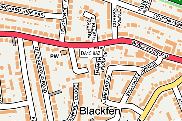
DA15 8AZ is located in the Blackfen & Lamorbey electoral ward, within the London borough of Bexley and the English Parliamentary constituency of Old Bexley and Sidcup. The Sub Integrated Care Board (ICB) Location is NHS South East London ICB - 72Q and the police force is Metropolitan Police. This postcode has been in use since March 2011.


GetTheData
Source: OS OpenMap – Local (Ordnance Survey)
Source: OS VectorMap District (Ordnance Survey)
Licence: Open Government Licence (requires attribution)
| Easting | 545823 |
| Northing | 174520 |
| Latitude | 51.450893 |
| Longitude | 0.097208 |
GetTheData
Source: Open Postcode Geo
Licence: Open Government Licence
| Country | England |
| Postcode District | DA15 |
➜ See where DA15 is on a map ➜ Where is London? | |
GetTheData
Source: Land Registry Price Paid Data
Licence: Open Government Licence
Elevation or altitude of DA15 8AZ as distance above sea level:
| Metres | Feet | |
|---|---|---|
| Elevation | 40m | 131ft |
Elevation is measured from the approximate centre of the postcode, to the nearest point on an OS contour line from OS Terrain 50, which has contour spacing of ten vertical metres.
➜ How high above sea level am I? Find the elevation of your current position using your device's GPS.
GetTheData
Source: Open Postcode Elevation
Licence: Open Government Licence
| Ward | Blackfen & Lamorbey |
| Constituency | Old Bexley And Sidcup |
GetTheData
Source: ONS Postcode Database
Licence: Open Government Licence
| Queenswood Road | Blackfen | 153m |
| Sycamore Avenue (Blackfen Road) | Blackfen | 211m |
| Queenswood Road | Blackfen | 222m |
| Blackfen Road Days Lane | Blackfen | 309m |
| Wellington Avenue Blackfen Rd (Wellington Avenue) | Blackfen | 397m |
| Falconwood Station | 1.5km |
| Welling Station | 1.6km |
| Sidcup Station | 1.9km |
GetTheData
Source: NaPTAN
Licence: Open Government Licence
| Percentage of properties with Next Generation Access | 100.0% |
| Percentage of properties with Superfast Broadband | 100.0% |
| Percentage of properties with Ultrafast Broadband | 0.0% |
| Percentage of properties with Full Fibre Broadband | 0.0% |
Superfast Broadband is between 30Mbps and 300Mbps
Ultrafast Broadband is > 300Mbps
| Percentage of properties unable to receive 2Mbps | 0.0% |
| Percentage of properties unable to receive 5Mbps | 0.0% |
| Percentage of properties unable to receive 10Mbps | 0.0% |
| Percentage of properties unable to receive 30Mbps | 0.0% |
GetTheData
Source: Ofcom
Licence: Ofcom Terms of Use (requires attribution)
GetTheData
Source: ONS Postcode Database
Licence: Open Government Licence


➜ Get more ratings from the Food Standards Agency
GetTheData
Source: Food Standards Agency
Licence: FSA terms & conditions
| Last Collection | |||
|---|---|---|---|
| Location | Mon-Fri | Sat | Distance |
| Queenswood Road | 17:30 | 11:30 | 195m |
| Leechcroft Avenue | 17:30 | 11:30 | 233m |
| Station Road Upper | 17:30 | 11:30 | 290m |
GetTheData
Source: Dracos
Licence: Creative Commons Attribution-ShareAlike
The below table lists the International Territorial Level (ITL) codes (formerly Nomenclature of Territorial Units for Statistics (NUTS) codes) and Local Administrative Units (LAU) codes for DA15 8AZ:
| ITL 1 Code | Name |
|---|---|
| TLI | London |
| ITL 2 Code | Name |
| TLI5 | Outer London - East and North East |
| ITL 3 Code | Name |
| TLI51 | Bexley and Greenwich |
| LAU 1 Code | Name |
| E09000004 | Bexley |
GetTheData
Source: ONS Postcode Directory
Licence: Open Government Licence
The below table lists the Census Output Area (OA), Lower Layer Super Output Area (LSOA), and Middle Layer Super Output Area (MSOA) for DA15 8AZ:
| Code | Name | |
|---|---|---|
| OA | E00001664 | |
| LSOA | E01000341 | Bexley 022A |
| MSOA | E02000086 | Bexley 022 |
GetTheData
Source: ONS Postcode Directory
Licence: Open Government Licence
| DA15 8PP | Hawthorn Terrace | 31m |
| DA15 8PU | Christopher Close | 43m |
| DA15 8PY | Blackfen Road | 68m |
| DA15 8PT | Blackfen Road | 68m |
| DA15 8PH | Lime Grove | 77m |
| DA15 8PJ | Lime Grove | 100m |
| DA15 8GU | Glebe Mews | 111m |
| DA15 8QA | Burleigh Avenue | 135m |
| DA15 8PX | Blackfen Road | 149m |
| DA15 8RP | Curran Avenue | 158m |
GetTheData
Source: Open Postcode Geo; Land Registry Price Paid Data
Licence: Open Government Licence