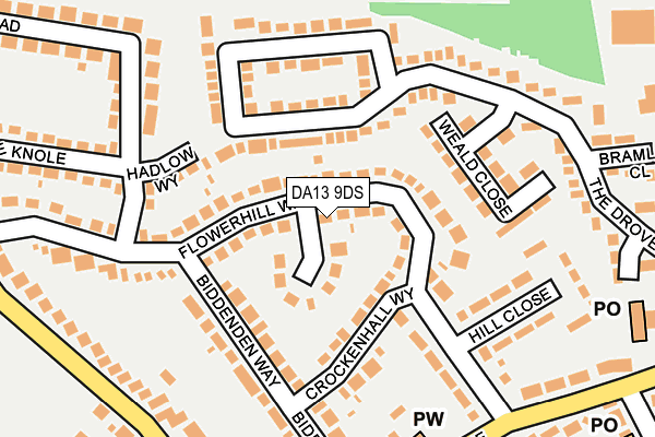
DA13 9DS lies on Flowerhill Way in Istead Rise, Gravesend. DA13 9DS is located in the Istead Rise, Cobham & Luddesdown electoral ward, within the local authority district of Gravesham and the English Parliamentary constituency of Gravesham. The Sub Integrated Care Board (ICB) Location is NHS Kent and Medway ICB - 91Q and the police force is Kent. This postcode has been in use since January 1980.


GetTheData
Source: OS OpenMap – Local (Ordnance Survey)
Source: OS VectorMap District (Ordnance Survey)
Licence: Open Government Licence (requires attribution)
| Easting | 563328 |
| Northing | 170167 |
| Latitude | 51.407012 |
| Longitude | 0.346909 |
GetTheData
Source: Open Postcode Geo
Licence: Open Government Licence
| Street | Flowerhill Way |
| Locality | Istead Rise |
| Town/City | Gravesend |
| Country | England |
| Postcode District | DA13 |
➜ See where DA13 is on a map ➜ Where is Istead Rise? | |
GetTheData
Source: Land Registry Price Paid Data
Licence: Open Government Licence
Elevation or altitude of DA13 9DS as distance above sea level:
| Metres | Feet | |
|---|---|---|
| Elevation | 60m | 197ft |
Elevation is measured from the approximate centre of the postcode, to the nearest point on an OS contour line from OS Terrain 50, which has contour spacing of ten vertical metres.
➜ How high above sea level am I? Find the elevation of your current position using your device's GPS.
GetTheData
Source: Open Postcode Elevation
Licence: Open Government Licence
| Ward | Istead Rise, Cobham & Luddesdown |
| Constituency | Gravesham |
GetTheData
Source: ONS Postcode Database
Licence: Open Government Licence
2012 30 APR £300,000 |
2001 16 JUL £141,000 |
GetTheData
Source: HM Land Registry Price Paid Data
Licence: Contains HM Land Registry data © Crown copyright and database right 2025. This data is licensed under the Open Government Licence v3.0.
| Littlecroft (Flowerhill Way) | Istead Rise | 30m |
| Littlecroft (Flowerhill Way) | Istead Rise | 39m |
| Longwalk (Downs Road) | Istead Rise | 284m |
| Longwalk (Downs Road) | Istead Rise | 288m |
| Shops (Istead Rise) | Istead Rise | 332m |
| Meopham Station | 2.4km |
| Sole Street Station | 3.4km |
| Longfield Station | 3.5km |
GetTheData
Source: NaPTAN
Licence: Open Government Licence
| Percentage of properties with Next Generation Access | 100.0% |
| Percentage of properties with Superfast Broadband | 100.0% |
| Percentage of properties with Ultrafast Broadband | 0.0% |
| Percentage of properties with Full Fibre Broadband | 0.0% |
Superfast Broadband is between 30Mbps and 300Mbps
Ultrafast Broadband is > 300Mbps
| Median download speed | 40.0Mbps |
| Average download speed | 42.4Mbps |
| Maximum download speed | 73.79Mbps |
| Median upload speed | 10.0Mbps |
| Average upload speed | 11.6Mbps |
| Maximum upload speed | 20.00Mbps |
| Percentage of properties unable to receive 2Mbps | 0.0% |
| Percentage of properties unable to receive 5Mbps | 0.0% |
| Percentage of properties unable to receive 10Mbps | 0.0% |
| Percentage of properties unable to receive 30Mbps | 0.0% |
GetTheData
Source: Ofcom
Licence: Ofcom Terms of Use (requires attribution)
Estimated total energy consumption in DA13 9DS by fuel type, 2015.
| Consumption (kWh) | 340,132 |
|---|---|
| Meter count | 24 |
| Mean (kWh/meter) | 14,172 |
| Median (kWh/meter) | 14,623 |
| Consumption (kWh) | 106,265 |
|---|---|
| Meter count | 23 |
| Mean (kWh/meter) | 4,620 |
| Median (kWh/meter) | 3,913 |
GetTheData
Source: Postcode level gas estimates: 2015 (experimental)
Source: Postcode level electricity estimates: 2015 (experimental)
Licence: Open Government Licence
GetTheData
Source: ONS Postcode Database
Licence: Open Government Licence


➜ Get more ratings from the Food Standards Agency
GetTheData
Source: Food Standards Agency
Licence: FSA terms & conditions
| Last Collection | |||
|---|---|---|---|
| Location | Mon-Fri | Sat | Distance |
| Biddenden | 16:30 | 09:00 | 140m |
| Istead Rise Post Office | 17:00 | 09:00 | 312m |
| Bungalow | 17:00 | 09:00 | 314m |
GetTheData
Source: Dracos
Licence: Creative Commons Attribution-ShareAlike
The below table lists the International Territorial Level (ITL) codes (formerly Nomenclature of Territorial Units for Statistics (NUTS) codes) and Local Administrative Units (LAU) codes for DA13 9DS:
| ITL 1 Code | Name |
|---|---|
| TLJ | South East (England) |
| ITL 2 Code | Name |
| TLJ4 | Kent |
| ITL 3 Code | Name |
| TLJ43 | Kent Thames Gateway |
| LAU 1 Code | Name |
| E07000109 | Gravesham |
GetTheData
Source: ONS Postcode Directory
Licence: Open Government Licence
The below table lists the Census Output Area (OA), Lower Layer Super Output Area (LSOA), and Middle Layer Super Output Area (MSOA) for DA13 9DS:
| Code | Name | |
|---|---|---|
| OA | E00123217 | |
| LSOA | E01024269 | Gravesham 012B |
| MSOA | E02005066 | Gravesham 012 |
GetTheData
Source: ONS Postcode Directory
Licence: Open Government Licence
| DA13 9DQ | Flowerhill Way | 38m |
| DA13 9DH | Little Croft | 70m |
| DA13 9JY | The Drove Way | 97m |
| DA13 9DB | Crockenhall Way | 106m |
| DA13 9DL | Hadlow Way | 133m |
| DA13 9DE | Biddenden Way | 153m |
| DA13 9DG | Flowerhill Way | 157m |
| DA13 9JX | Weald Close | 160m |
| DA13 9DU | Fairview Road | 166m |
| DA13 9DD | Hill Close | 185m |
GetTheData
Source: Open Postcode Geo; Land Registry Price Paid Data
Licence: Open Government Licence