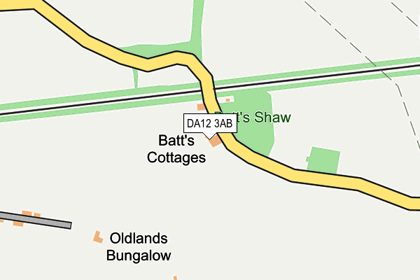
DA12 3AB is located in the Istead Rise, Cobham & Luddesdown electoral ward, within the local authority district of Gravesham and the English Parliamentary constituency of Gravesham. The Sub Integrated Care Board (ICB) Location is NHS Kent and Medway ICB - 91Q and the police force is Kent. This postcode has been in use since January 1980.


GetTheData
Source: OS OpenMap – Local (Ordnance Survey)
Source: OS VectorMap District (Ordnance Survey)
Licence: Open Government Licence (requires attribution)
| Easting | 566843 |
| Northing | 167505 |
| Latitude | 51.382074 |
| Longitude | 0.396179 |
GetTheData
Source: Open Postcode Geo
Licence: Open Government Licence
| Country | England |
| Postcode District | DA12 |
➜ See where DA12 is on a map | |
GetTheData
Source: Land Registry Price Paid Data
Licence: Open Government Licence
Elevation or altitude of DA12 3AB as distance above sea level:
| Metres | Feet | |
|---|---|---|
| Elevation | 90m | 295ft |
Elevation is measured from the approximate centre of the postcode, to the nearest point on an OS contour line from OS Terrain 50, which has contour spacing of ten vertical metres.
➜ How high above sea level am I? Find the elevation of your current position using your device's GPS.
GetTheData
Source: Open Postcode Elevation
Licence: Open Government Licence
| Ward | Istead Rise, Cobham & Luddesdown |
| Constituency | Gravesham |
GetTheData
Source: ONS Postcode Database
Licence: Open Government Licence
| New College (Cobhambury Road) | Cobham | 875m |
| Church (The Street) | Cobham | 938m |
| Church (The Street) | Cobham | 948m |
| The Ship (The Street) | Cobham | 1,015m |
| War Memorial (The Street) | Cobham | 1,044m |
| Sole Street Station | 1.3km |
| Meopham Station | 2.8km |
| Cuxton Station | 4.7km |
GetTheData
Source: NaPTAN
Licence: Open Government Licence
| Percentage of properties with Next Generation Access | 100.0% |
| Percentage of properties with Superfast Broadband | 0.0% |
| Percentage of properties with Ultrafast Broadband | 0.0% |
| Percentage of properties with Full Fibre Broadband | 0.0% |
Superfast Broadband is between 30Mbps and 300Mbps
Ultrafast Broadband is > 300Mbps
| Percentage of properties unable to receive 2Mbps | 0.0% |
| Percentage of properties unable to receive 5Mbps | 0.0% |
| Percentage of properties unable to receive 10Mbps | 0.0% |
| Percentage of properties unable to receive 30Mbps | 100.0% |
GetTheData
Source: Ofcom
Licence: Ofcom Terms of Use (requires attribution)
GetTheData
Source: ONS Postcode Database
Licence: Open Government Licence


➜ Get more ratings from the Food Standards Agency
GetTheData
Source: Food Standards Agency
Licence: FSA terms & conditions
| Last Collection | |||
|---|---|---|---|
| Location | Mon-Fri | Sat | Distance |
| Henley Street | 16:30 | 09:00 | 401m |
| Sole Street | 16:30 | 09:00 | 1,121m |
| Sole Street | 16:45 | 09:00 | 1,158m |
GetTheData
Source: Dracos
Licence: Creative Commons Attribution-ShareAlike
The below table lists the International Territorial Level (ITL) codes (formerly Nomenclature of Territorial Units for Statistics (NUTS) codes) and Local Administrative Units (LAU) codes for DA12 3AB:
| ITL 1 Code | Name |
|---|---|
| TLJ | South East (England) |
| ITL 2 Code | Name |
| TLJ4 | Kent |
| ITL 3 Code | Name |
| TLJ43 | Kent Thames Gateway |
| LAU 1 Code | Name |
| E07000109 | Gravesham |
GetTheData
Source: ONS Postcode Directory
Licence: Open Government Licence
The below table lists the Census Output Area (OA), Lower Layer Super Output Area (LSOA), and Middle Layer Super Output Area (MSOA) for DA12 3AB:
| Code | Name | |
|---|---|---|
| OA | E00123368 | |
| LSOA | E01024301 | Gravesham 010E |
| MSOA | E02005064 | Gravesham 010 |
GetTheData
Source: ONS Postcode Directory
Licence: Open Government Licence
| DA13 0XB | Henley Street | 393m |
| DA13 0XD | Hays Mead | 472m |
| DA12 3AA | Gold Street | 834m |
| DA12 3BU | Lawrence Drive | 908m |
| DA12 3BX | The Street | 938m |
| DA12 3BW | The Street | 983m |
| DA12 3BZ | The Street | 985m |
| DA12 3BN | The Street | 1011m |
| DA12 3DF | The Terrace | 1039m |
| DA12 3AT | Greenlands | 1056m |
GetTheData
Source: Open Postcode Geo; Land Registry Price Paid Data
Licence: Open Government Licence