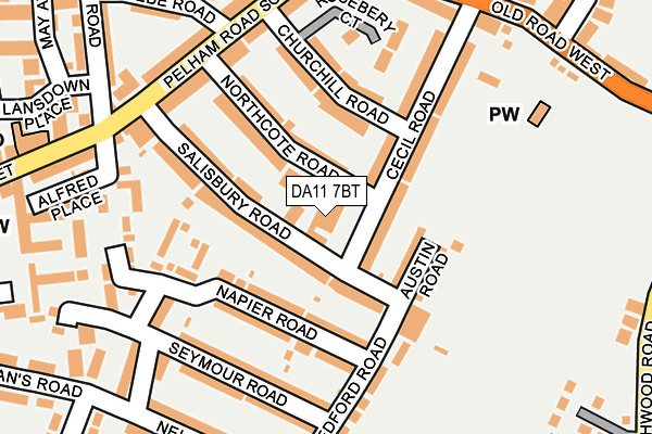
DA11 7BT is located in the Coldharbour & Perry Street electoral ward, within the local authority district of Gravesham and the English Parliamentary constituency of Gravesham. The Sub Integrated Care Board (ICB) Location is NHS Kent and Medway ICB - 91Q and the police force is Kent. This postcode has been in use since January 1980.


GetTheData
Source: OS OpenMap – Local (Ordnance Survey)
Source: OS VectorMap District (Ordnance Survey)
Licence: Open Government Licence (requires attribution)
| Easting | 563896 |
| Northing | 173123 |
| Latitude | 51.433404 |
| Longitude | 0.356434 |
GetTheData
Source: Open Postcode Geo
Licence: Open Government Licence
| Country | England |
| Postcode District | DA11 |
➜ See where DA11 is on a map ➜ Where is Northfleet? | |
GetTheData
Source: Land Registry Price Paid Data
Licence: Open Government Licence
Elevation or altitude of DA11 7BT as distance above sea level:
| Metres | Feet | |
|---|---|---|
| Elevation | 20m | 66ft |
Elevation is measured from the approximate centre of the postcode, to the nearest point on an OS contour line from OS Terrain 50, which has contour spacing of ten vertical metres.
➜ How high above sea level am I? Find the elevation of your current position using your device's GPS.
GetTheData
Source: Open Postcode Elevation
Licence: Open Government Licence
| Ward | Coldharbour & Perry Street |
| Constituency | Gravesham |
GetTheData
Source: ONS Postcode Database
Licence: Open Government Licence
| The Rose (Pelham Road South) | Perry Street | 194m |
| Cecil Road (Old Road West) | Northfleet | 225m |
| Bedford Road (Nelson Road) | Northfleet | 229m |
| The Rose (Perry Street) | Perry Street | 234m |
| Cecil Road (Old Road West) | Northfleet | 245m |
| Gravesend Station | 1.1km |
| Northfleet Station | 2.6km |
| Ebbsfleet International Station | 2.7km |
GetTheData
Source: NaPTAN
Licence: Open Government Licence
GetTheData
Source: ONS Postcode Database
Licence: Open Government Licence


➜ Get more ratings from the Food Standards Agency
GetTheData
Source: Food Standards Agency
Licence: FSA terms & conditions
| Last Collection | |||
|---|---|---|---|
| Location | Mon-Fri | Sat | Distance |
| Perry Street Post Office | 17:30 | 11:15 | 261m |
| Dashwood Road | 17:30 | 11:00 | 319m |
| Pelham Road | 18:30 | 11:15 | 377m |
GetTheData
Source: Dracos
Licence: Creative Commons Attribution-ShareAlike
The below table lists the International Territorial Level (ITL) codes (formerly Nomenclature of Territorial Units for Statistics (NUTS) codes) and Local Administrative Units (LAU) codes for DA11 7BT:
| ITL 1 Code | Name |
|---|---|
| TLJ | South East (England) |
| ITL 2 Code | Name |
| TLJ4 | Kent |
| ITL 3 Code | Name |
| TLJ43 | Kent Thames Gateway |
| LAU 1 Code | Name |
| E07000109 | Gravesham |
GetTheData
Source: ONS Postcode Directory
Licence: Open Government Licence
The below table lists the Census Output Area (OA), Lower Layer Super Output Area (LSOA), and Middle Layer Super Output Area (MSOA) for DA11 7BT:
| Code | Name | |
|---|---|---|
| OA | E00123273 | |
| LSOA | E01024284 | Gravesham 004E |
| MSOA | E02005058 | Gravesham 004 |
GetTheData
Source: ONS Postcode Directory
Licence: Open Government Licence
| DA11 7DE | Salisbury Road | 68m |
| DA11 7BZ | Napier Road | 91m |
| DA11 7BS | Northcote Road | 106m |
| DA11 7DG | Cecil Road | 108m |
| DA11 7DF | Salisbury Road | 109m |
| DA11 7BP | Austin Road | 110m |
| DA11 7DQ | Cecil Road | 117m |
| DA11 7BY | Napier Road | 118m |
| DA11 7AQ | Churchill Road | 132m |
| DA11 7BN | Seymour Road | 157m |
GetTheData
Source: Open Postcode Geo; Land Registry Price Paid Data
Licence: Open Government Licence