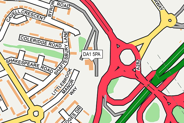
DA1 5PA is located in the Temple Hill electoral ward, within the local authority district of Dartford and the English Parliamentary constituency of Dartford. The Sub Integrated Care Board (ICB) Location is NHS Kent and Medway ICB - 91Q and the police force is Kent. This postcode has been in use since December 1997.


GetTheData
Source: OS OpenMap – Local (Ordnance Survey)
Source: OS VectorMap District (Ordnance Survey)
Licence: Open Government Licence (requires attribution)
| Easting | 555709 |
| Northing | 175143 |
| Latitude | 51.453861 |
| Longitude | 0.239642 |
GetTheData
Source: Open Postcode Geo
Licence: Open Government Licence
| Country | England |
| Postcode District | DA1 |
➜ See where DA1 is on a map ➜ Where is Dartford? | |
GetTheData
Source: Land Registry Price Paid Data
Licence: Open Government Licence
Elevation or altitude of DA1 5PA as distance above sea level:
| Metres | Feet | |
|---|---|---|
| Elevation | 20m | 66ft |
Elevation is measured from the approximate centre of the postcode, to the nearest point on an OS contour line from OS Terrain 50, which has contour spacing of ten vertical metres.
➜ How high above sea level am I? Find the elevation of your current position using your device's GPS.
GetTheData
Source: Open Postcode Elevation
Licence: Open Government Licence
| Ward | Temple Hill |
| Constituency | Dartford |
GetTheData
Source: ONS Postcode Database
Licence: Open Government Licence
| Tennyson Road (Littlebrook Manor Way) | Temple Hill | 287m |
| Bridges Drive (Attlee Drive) | Temple Hill | 294m |
| Cavell Crescent (Henderson Drive) | Temple Hill | 311m |
| Bridges Drive (Attlee Drive) | Temple Hill | 315m |
| Tennyson Road (Littlebrook Manor Way) | Temple Hill | 321m |
| Dartford Station | 1.6km |
| Stone Crossing Station | 1.7km |
| Greenhithe for Bluewater Station | 2.9km |
GetTheData
Source: NaPTAN
Licence: Open Government Licence
GetTheData
Source: ONS Postcode Database
Licence: Open Government Licence


➜ Get more ratings from the Food Standards Agency
GetTheData
Source: Food Standards Agency
Licence: FSA terms & conditions
| Last Collection | |||
|---|---|---|---|
| Location | Mon-Fri | Sat | Distance |
| Farnol Road | 17:30 | 11:15 | 286m |
| Attlee Drive | 17:30 | 11:30 | 623m |
| Keyes Road | 17:30 | 11:15 | 624m |
GetTheData
Source: Dracos
Licence: Creative Commons Attribution-ShareAlike
The below table lists the International Territorial Level (ITL) codes (formerly Nomenclature of Territorial Units for Statistics (NUTS) codes) and Local Administrative Units (LAU) codes for DA1 5PA:
| ITL 1 Code | Name |
|---|---|
| TLJ | South East (England) |
| ITL 2 Code | Name |
| TLJ4 | Kent |
| ITL 3 Code | Name |
| TLJ43 | Kent Thames Gateway |
| LAU 1 Code | Name |
| E07000107 | Dartford |
GetTheData
Source: ONS Postcode Directory
Licence: Open Government Licence
The below table lists the Census Output Area (OA), Lower Layer Super Output Area (LSOA), and Middle Layer Super Output Area (MSOA) for DA1 5PA:
| Code | Name | |
|---|---|---|
| OA | E00122622 | |
| LSOA | E01024154 | Dartford 001C |
| MSOA | E02005028 | Dartford 001 |
GetTheData
Source: ONS Postcode Directory
Licence: Open Government Licence
| DA1 5NP | Shaftesbury Lane | 113m |
| DA1 5DU | Littlebrook Manorway | 151m |
| DA1 5NT | Byron Road | 182m |
| DA1 5NR | Coleridge Road | 185m |
| DA1 5NN | Shakespeare Road | 186m |
| DA1 5EF | Littlebrook Manorway | 193m |
| DA1 5NW | Shakespeare Road | 202m |
| DA1 5DS | Kipling Road | 204m |
| DA1 5DR | Bridges Drive | 207m |
| DA1 5NS | Cavell Crescent | 221m |
GetTheData
Source: Open Postcode Geo; Land Registry Price Paid Data
Licence: Open Government Licence