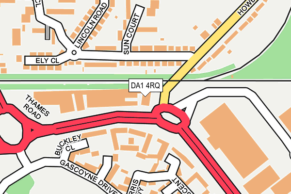
DA1 4RQ is located in the Crayford electoral ward, within the London borough of Bexley and the English Parliamentary constituency of Bexleyheath and Crayford. The Sub Integrated Care Board (ICB) Location is NHS South East London ICB - 72Q and the police force is Metropolitan Police. This postcode has been in use since June 1999.


GetTheData
Source: OS OpenMap – Local (Ordnance Survey)
Source: OS VectorMap District (Ordnance Survey)
Licence: Open Government Licence (requires attribution)
| Easting | 551988 |
| Northing | 176141 |
| Latitude | 51.463838 |
| Longitude | 0.186559 |
GetTheData
Source: Open Postcode Geo
Licence: Open Government Licence
| Country | England |
| Postcode District | DA1 |
➜ See where DA1 is on a map ➜ Where is London? | |
GetTheData
Source: Land Registry Price Paid Data
Licence: Open Government Licence
Elevation or altitude of DA1 4RQ as distance above sea level:
| Metres | Feet | |
|---|---|---|
| Elevation | 10m | 33ft |
Elevation is measured from the approximate centre of the postcode, to the nearest point on an OS contour line from OS Terrain 50, which has contour spacing of ten vertical metres.
➜ How high above sea level am I? Find the elevation of your current position using your device's GPS.
GetTheData
Source: Open Postcode Elevation
Licence: Open Government Licence
| Ward | Crayford |
| Constituency | Bexleyheath And Crayford |
GetTheData
Source: ONS Postcode Database
Licence: Open Government Licence
| Howbury Lane | Slade Green | 143m |
| Thames Road (Da1) | Slade Green | 150m |
| Lincoln Road (Howbury Lane) | Slade Green | 211m |
| Shearwood Crescent | Slade Green | 216m |
| Shearwood Crescent | Slade Green | 216m |
| Slade Green Station | 0.5km |
| Crayford Station | 1.8km |
| Barnehurst Station | 1.9km |
GetTheData
Source: NaPTAN
Licence: Open Government Licence
| Median download speed | 60.4Mbps |
| Average download speed | 54.6Mbps |
| Maximum download speed | 65.46Mbps |
| Median upload speed | 12.8Mbps |
| Average upload speed | 12.6Mbps |
| Maximum upload speed | 15.72Mbps |
GetTheData
Source: Ofcom
Licence: Ofcom Terms of Use (requires attribution)
GetTheData
Source: ONS Postcode Database
Licence: Open Government Licence


➜ Get more ratings from the Food Standards Agency
GetTheData
Source: Food Standards Agency
Licence: FSA terms & conditions
| Last Collection | |||
|---|---|---|---|
| Location | Mon-Fri | Sat | Distance |
| Lincoln Close | 17:30 | 11:30 | 191m |
| Bridge Road | 17:30 | 11:30 | 502m |
| Forest Road Post Office | 17:30 | 12:15 | 565m |
GetTheData
Source: Dracos
Licence: Creative Commons Attribution-ShareAlike
The below table lists the International Territorial Level (ITL) codes (formerly Nomenclature of Territorial Units for Statistics (NUTS) codes) and Local Administrative Units (LAU) codes for DA1 4RQ:
| ITL 1 Code | Name |
|---|---|
| TLI | London |
| ITL 2 Code | Name |
| TLI5 | Outer London - East and North East |
| ITL 3 Code | Name |
| TLI51 | Bexley and Greenwich |
| LAU 1 Code | Name |
| E09000004 | Bexley |
GetTheData
Source: ONS Postcode Directory
Licence: Open Government Licence
The below table lists the Census Output Area (OA), Lower Layer Super Output Area (LSOA), and Middle Layer Super Output Area (MSOA) for DA1 4RQ:
| Code | Name | |
|---|---|---|
| OA | E00001858 | |
| LSOA | E01000380 | Bexley 010D |
| MSOA | E02000074 | Bexley 010 |
GetTheData
Source: ONS Postcode Directory
Licence: Open Government Licence
| DA8 2DT | Lincoln Road | 86m |
| DA8 2DU | Lincoln Road | 107m |
| DA8 2DY | Sun Court | 141m |
| DA8 2DZ | Sun Court | 184m |
| DA8 2DX | Lincoln Road | 189m |
| DA1 4SU | Shearwood Crescent | 197m |
| DA1 4TL | Norris Way | 201m |
| DA8 2DS | Howbury Lane | 204m |
| DA1 4TD | Shearwood Crescent | 211m |
| DA8 2EE | Lincoln Road | 216m |
GetTheData
Source: Open Postcode Geo; Land Registry Price Paid Data
Licence: Open Government Licence