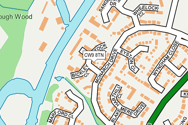
CW9 8TN lies on Wrenbury Drive in Northwich. CW9 8TN is located in the Davenham, Moulton & Kingsmead electoral ward, within the unitary authority of Cheshire West and Chester and the English Parliamentary constituency of Weaver Vale. The Sub Integrated Care Board (ICB) Location is NHS Cheshire and Merseyside ICB - 27D and the police force is Cheshire. This postcode has been in use since March 2003.


GetTheData
Source: OS OpenMap – Local (Ordnance Survey)
Source: OS VectorMap District (Ordnance Survey)
Licence: Open Government Licence (requires attribution)
| Easting | 365373 |
| Northing | 372396 |
| Latitude | 53.247459 |
| Longitude | -2.520386 |
GetTheData
Source: Open Postcode Geo
Licence: Open Government Licence
| Street | Wrenbury Drive |
| Town/City | Northwich |
| Country | England |
| Postcode District | CW9 |
➜ See where CW9 is on a map ➜ Where is Kingsmead? | |
GetTheData
Source: Land Registry Price Paid Data
Licence: Open Government Licence
Elevation or altitude of CW9 8TN as distance above sea level:
| Metres | Feet | |
|---|---|---|
| Elevation | 20m | 66ft |
Elevation is measured from the approximate centre of the postcode, to the nearest point on an OS contour line from OS Terrain 50, which has contour spacing of ten vertical metres.
➜ How high above sea level am I? Find the elevation of your current position using your device's GPS.
GetTheData
Source: Open Postcode Elevation
Licence: Open Government Licence
| Ward | Davenham, Moulton & Kingsmead |
| Constituency | Weaver Vale |
GetTheData
Source: ONS Postcode Database
Licence: Open Government Licence
2019 7 NOV £340,000 |
2017 24 MAY £360,000 |
2016 20 DEC £371,250 |
2004 28 MAY £249,950 |
2004 18 MAY £260,950 |
GetTheData
Source: HM Land Registry Price Paid Data
Licence: Contains HM Land Registry data © Crown copyright and database right 2025. This data is licensed under the Open Government Licence v3.0.
| Monarch Drive (Kingsmead) | Kingsmead | 244m |
| Monarch Drive (Kingsmead) | Kingsmead | 286m |
| St Wilfrids Rc Primary School (Grounds) | Hartford | 494m |
| Sir John Deanes College (Grounds) | Leftwich | 525m |
| Sir John Deane's College (Kingsmead) | Leftwich | 527m |
| Greenbank Station | 1km |
| Northwich Station | 2.2km |
| Hartford Station | 2.3km |
GetTheData
Source: NaPTAN
Licence: Open Government Licence
| Percentage of properties with Next Generation Access | 100.0% |
| Percentage of properties with Superfast Broadband | 100.0% |
| Percentage of properties with Ultrafast Broadband | 0.0% |
| Percentage of properties with Full Fibre Broadband | 0.0% |
Superfast Broadband is between 30Mbps and 300Mbps
Ultrafast Broadband is > 300Mbps
| Percentage of properties unable to receive 2Mbps | 0.0% |
| Percentage of properties unable to receive 5Mbps | 0.0% |
| Percentage of properties unable to receive 10Mbps | 0.0% |
| Percentage of properties unable to receive 30Mbps | 0.0% |
GetTheData
Source: Ofcom
Licence: Ofcom Terms of Use (requires attribution)
GetTheData
Source: ONS Postcode Database
Licence: Open Government Licence


➜ Get more ratings from the Food Standards Agency
GetTheData
Source: Food Standards Agency
Licence: FSA terms & conditions
| Last Collection | |||
|---|---|---|---|
| Location | Mon-Fri | Sat | Distance |
| Kingsmead Square | 16:00 | 11:30 | 501m |
| Hartford Road | 17:30 | 08:00 | 755m |
| London Road | 17:30 | 11:00 | 1,371m |
GetTheData
Source: Dracos
Licence: Creative Commons Attribution-ShareAlike
The below table lists the International Territorial Level (ITL) codes (formerly Nomenclature of Territorial Units for Statistics (NUTS) codes) and Local Administrative Units (LAU) codes for CW9 8TN:
| ITL 1 Code | Name |
|---|---|
| TLD | North West (England) |
| ITL 2 Code | Name |
| TLD6 | Cheshire |
| ITL 3 Code | Name |
| TLD63 | Cheshire West and Chester |
| LAU 1 Code | Name |
| E06000050 | Cheshire West and Chester |
GetTheData
Source: ONS Postcode Directory
Licence: Open Government Licence
The below table lists the Census Output Area (OA), Lower Layer Super Output Area (LSOA), and Middle Layer Super Output Area (MSOA) for CW9 8TN:
| Code | Name | |
|---|---|---|
| OA | E00168845 | |
| LSOA | E01018700 | Cheshire West and Chester 023D |
| MSOA | E02003883 | Cheshire West and Chester 023 |
GetTheData
Source: ONS Postcode Directory
Licence: Open Government Licence
| CW9 8TL | Lostock Close | 32m |
| CW9 8RW | Wrenbury Drive | 39m |
| CW9 8TH | Monarch Drive | 45m |
| CW9 8TJ | Bickley Close | 67m |
| CW9 8RX | Wrenbury Drive | 67m |
| CW9 8TG | Wrenbury Drive | 69m |
| CW9 8UN | Monarch Drive | 70m |
| CW9 8TT | Sandbach Drive | 107m |
| CW9 8UU | Harthill Close | 108m |
| CW9 8TU | Sandbach Drive | 122m |
GetTheData
Source: Open Postcode Geo; Land Registry Price Paid Data
Licence: Open Government Licence